
Where Flight Simulation Enthusiasts Gather from Around the World!
AVSIM Library - Search Results

| Category: Flight Simulator X - Scenery | |
| MTPP - Toussaint Louverture Airport, Haiti |

|
File Description:
This is an enhanced airport scenery for MTPP Toussaint Louverture Airport in Haiti. In addition to the airport facility data, airport photo scenery is provided. The following other airports' facility data are updated: MTCA Cayes, MTCH Cap Haitien Intl, MTJA Jacmel, MTJE Jeremie, and MTPX Port De Paix. A modified season file is provided to show summer terrain textures in central Haiti vice the default fall/winter textures.
| Filename: | MTPP__Toussaint_Louverture_Airport_Haiti.zip |
| License: | Freeware, limited distribution |
| Added: | 26th January 2010, 19:46:48 |
| Downloads: | 5,684 |
| Author: | Scott Smart |
| Size: | 12.01 MB |
| Category: Flight Simulator X - Scenery | |
| SVCJ - San Carlos Airport - Venezuela |
|
Images related to this file:
File Description:
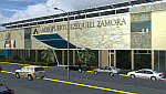
The National Airport "Ezequiel Zamora" is an airport located in the city of San Carlos, being the most important of the Cojedes State
Recently remodeled which includes the adequacy of the runway for aircraft such as the McDonnell Douglas DC-9, Boeing 737, Airbus A319. Photo-terrain area improved with Autogen files.
Only compatible with versions of FSX, P3Dv1.x or P3Dv2.x. Also includes a friendly Auto-Install.
| Filename: | SVCJ__San_Carlos_Airport___Venezuela.zip |
| License: | Freeware |
| Added: | 27th July 2014, 18:01:12 |
| Downloads: | 1,072 |
| Author: | David Maldonado |
| Size: | 61.28 MB |
| Category: Flight Simulator 2002 - Scenery Design | |
| BGL Analyze Disassembler |
|
File Description:
The BGL Analyze program version 3.1 is an improved version with correction of some bugs in the 3.0 version. It will disassemble FS98, FS2000 and FS2002 scenery files. The output is SCASM code for most sections, but since there are no SCASM instructions available for the new FS2002 scenery files with terrain polygons (LWM and VTP), output for those section is assembler code that can be recompiles with BGLC.
| Filename: | BGL_Analyze_Disassembler.zip |
| License: | Freeware |
| Added: | 27th February 2003, 19:44:13 |
| Downloads: | 7,772 |
| Author: | Winfried Orthmann |
| Size: | 194.24 KB |
| Category: Flight Simulator 2004 - Scenery | |
| North Haledon |
|
File Description:
North Haledon is a small town in Northern New Jersey, USA. This is Chopper Friendly scenery, folks. It wasn't designed to be flown over at 10,000 feet - although, if you like to fly heavy iron into the major New York/New Jersey airports, you'll notice that it replaces the terrain elevation of Northern New Jersey with all the hills and valleys that the default scenery left out. No, this is interactive scenery. Built to be explored low and slow. Want to perfect your landing skills in a huge playground of rooftops, irregular terrain, and tight spaces? This is the place. You won't find any unlandable surfaces or false crashes here - just hundreds of places to touch down ranging from beginner, through expert, to downright sick! There's a police station with landable helipad, four schools, ballfields, an optional forest fire (with a scenic lake nearby for refilling), too many highly detailed houses and buildings to count, and much more.
| Filename: | North_Haledon.zip |
| License: | Freeware, limited distribution |
| Added: | 25th April 2006, 02:48:26 |
| Downloads: | 1,925 |
| Author: | Mick Posch |
| Size: | 13.14 MB |
| Category: Flight Simulator 2004 - AFCAD Files | |
| King Khalid AB, Khamis Mushait, Saudi Arabia (OEKM) |
|
File Description:
King Khalid AB, Khamis Mushait, Saudi Arabia (OEKM) for Microsoft default scenery only. This airport is located in mountainous terrain, in the southwest corner of the country, not far from both the Red Sea coast and the border with Yemen. No material changes were made to the stock airport layout as the ramps and taxiway network were already complete and free of errors. I have added 78 parking spaces:- 23 GA; 26 Mil_combat; 10 BBJ; 8 Gate Small; 3 Gate Medium; 2 Gate Heavy; 4 Mil_Cargo; 2 Civilian cargo. Parking code settings are for SVA, SVAV, BBJ, M000-M003. At the time of writing, scheduled airlines fly to nearby Abha airport. If you use Ed Kooymans' AI flightplans then you will see some AI activity at Khamis. Flights from OEKM direct to OETB overfly Jeddah en route but, when writing your own flightplans, note that the elevation of OEKM is 6778' and local terrain is higher still.
| Filename: | King_Khalid_AB_Khamis_Mushait_Saudi_Arabia_OEKM.zip |
| License: | Freeware, limited distribution |
| Added: | 1st September 2006, 20:08:31 |
| Downloads: | 992 |
| Author: | Mark S. Cherry |
| Size: | 9.38 KB |
| Category: Flight Simulator 2004 - Scenery | |
| Branson Airport KBBG--New Airport, Scenery, and Flight Plans |
|
Images related to this file:
File Description:
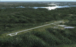
This project adds a new Branson Airport KBBG (Missouri) to FS 2004, which opened in May 2009, and is a privately developed commercial airport. The construction of the airport, which involved the flattening of several Ozark Mountains, is claimed to be the largest earthmoving project in Missouri history. As a result, the airport actually sits on a manmade plateau, surrounded by rolling hills. The airport uses the ICAO identifier BBG, however, the airlines use the IATA code BKG. The airport is served by AirTran, Frontier, and ExpressJet (Branson AirExpress), and is located in hilly terrain. Aircraft equipped with a terrain avoidance warning system may experience system activation on final approach. AFCAD created using Airport Design Editor 9 v1.47.07, and the hilltops were cleared and flattened and roads were added using SBuilder 2.05 revision 06. The terminal and hangar were added and modified from within Airport Design Editor 9. This airport is based on my more detailed FSX version, Branson_Airport_Project.zip.
| Filename: | Branson_Airport_KBBGNew_Airport_Scenery_and_Flight.zip |
| License: | Freeware |
| Added: | 16th August 2010, 20:50:16 |
| Downloads: | 1,734 |
| Author: | Carlyle Sharpe |
| Size: | 3.23 MB |
| Category: Flight Simulator 2004 - Scenery | |
| Monument Valley UT25 and Oljato 05UT in Utah USA |
|
Images related to this file:
File Description:
Monument Valley is an impressive sight in south Utah but not, unfortunately, in FS9. Unless you invest in a detailed terrain mesh there are no stacks of rocks reaching for the sky and the lasting overall impression is just of a desert. But I had already downloaded the land textures so I ended up making the Monument Valley UT25 airfield and the nearby Oljato 05UT, which has no buildings of any sort. Maybe I was bored. There is a lodge close to the field with dozens of cabins, but I had insufficient information so this is for the airfield only. The 4,000 feet of new tarmac is aligned 16-34 and is single ended with a large chunk of rock at the southern end; 16 is only used for landing and 34 is only for take off. The runway is not lit. Do not be surprised when you ask to select a runway for take off and FS9 only gives you 16 as a choice, even though you know this is the wrong one. When you accept it FS9 will quickly switch it to 34; apart from a possible sense of humour I have no idea why it does this. Nothing much to say about Oljato. What do you need? You actually don't need Ultimate Terrain as there are other land textures used here, so you will definitely need to have downloaded and installed the land textures "cny_south3west_2010 lr" and "cny_south3west2_2010 lr" by Gottfried Razek, as these land textures showed the runways in the correct positions. Look in the scenery library here or at the other place. A note here about my scenery making. There will not be many more to follow this (unless you count 4 as many) as I am almost at the end of the photos I either took or found for scenery purposes, plus I expect to move on from FS9 at some point during next year.
| Filename: | Monument_Valley_UT25_and_Oljato_05UT_in_Utah_USA.zip |
| License: | Freeware, limited distribution |
| Added: | 22nd January 2020, 20:13:54 |
| Downloads: | 219 |
| Author: | Roger Wensley |
| Size: | 2.91 MB |
| Category: Flight Simulator 2004 - Scenery | |
| Lake Hood AI for LHD and Z41 in Anchorage Alaska |
|
Images related to this file:
File Description:
This has two float planes doing touch-and-goes on the lake and some planes taking off and landing on Lake Hood Airstrip Z41. This update (20 July 2010) revises the Z41 AI as I discovered that touch-and-goes do not work in FS9 on a runway that is under 4,000 feet, so they have been modified to flights between Z41 and PANC. It is a self contained update that includes the one new building that is modelled specifically for this scenery, plus some minor corrections such as moving a plane from where it is parked on top of a car. You should have already installed my recent post (July 2010) of Lake Hood LHD and the Lake Hood Airstrip Z41.
| Filename: | Lake_Hood_AI_for_LHD_and_Z41_in_Anchorage_Alaska.zip |
| License: | Freeware, limited distribution |
| Added: | 26th July 2010, 03:40:04 |
| Downloads: | 584 |
| Author: | Roger Wensley |
| Size: | 1.07 MB |
| Category: Flight Simulator 2004 - AI Aircraft | |
| Alaska Airlines Boeing 737-700 winglet 'PORTLAND TIMBERS' logojet (N607AS) |
|
Images related to this file:
File Description:

This repaint includes the '607' reg info above the fore windscreen. Also included are 32-bit textures. Textures only; requires the AIA Boeing 737-700w found here at AVSIM (filename AIA_737W.ZIP)
| Filename: | Alaska_Airlines_Boeing_737700_winglet_PORTLAND_TIM.zip |
| License: | Freeware, limited distribution |
| Added: | 14th June 2011, 06:07:59 |
| Downloads: | 1,222 |
| Author: | Jeffrey S. Bryner, AI Aardvark |
| Size: | 1.11 MB |
| Category: Flight Simulator 2004 - Scenery | |
| PAMR (Merrill Field, Anchorage), 5HO (Hope), 9Z9 (Lawing) - Alaska, USA |
|
Images related to this file:
File Description:
This stand-alone combined V2 version of Merrill Field 2016 includes: windsocks, a parked Fedex 727 that was recently donated to the University of Alaska, some missing taxiway lights, and small corrections to the apron layout. It also includes Hope 5HO and Lawing 9Z9. The 2016 version of Merrill Field PAMR dealt with a spectacular malfunction reported by one recent downloader; see the two screenshots. Merrill Field is in Anchorage Alaska, between Anchorage International to the southwest and and Elmendorf Air Force Base to the north. It caters for general aviation and is the land equivalent of the Lake Hood float plane base, with fuel and numerous maintenance facilities, and several hundred parking spots for small planes. There are three runways, and the longest is 4,000 feet of 100 feet wide asphalt, the second 2,635 feet of asphalt 75 feet wide, and the third 2,000 feet of 60 feet wide gravel. The first two have runway lights. It is a controlled airfield with a relatively new control tower to cater for the numerous flights and to coordinate with Elmensdorf and Anchorage International, the latter also controlling flights from Lake Hood and the adjacent gravel strip Z41 (see my Lake Hood scenery). The gravel runway at Merrill Field is not connected with active taxiways to the rest of the airfield; this avoids you being ordered to land on it when flying a plane too large to do so. The enclosed layout shows the runways and the taxiways complete with their assigned letters to help you find your way around, but note that this shows the current gravel runway with its wandering magnetic headings, not the ones prevailing when I made Merrill. The signage on the airfield is not total. The main taxiways are signed and each entry to a runway has a runway sign, but intermediate taxiways to or from a runway are not; if you have turned off the runway at the first possible exit you could then whether it is R or T is, I suppose, irrelevant. Try not to turn onto Merrill Field Drive at an intersection, this is a road that runs through the field. There are almost 50 buildings on the field and threequarters of them have been modelled from photographs specifically for this scenery; some of them were modelled from photos that were of not very good quality, but when the photos were taken I wasn't thinking that I would ever model the field. Which explains why there are buildings I had no photos of at all, of any sort of quality.
| Filename: | PAMR_Merrill_Field_Anchorage_5HO_Hope_9Z9_Lawing__.zip |
| License: | Freeware, limited distribution |
| Added: | 26th February 2016, 09:54:17 |
| Downloads: | 761 |
| Author: | Roger Wensley |
| Size: | 22.64 MB |


© 2001-2026 AVSIM Online
All Rights Reserved
Privacy Policy |