
Where Flight Simulation Enthusiasts Gather from Around the World!
AVSIM Library - Search Results

| Category: Flight Simulator X - Scenery | |
| CYYR, Goose Bay Airport, Labrador Canada |

|
Images related to this file:
File Description:
New setup of this airport I came across in one of my virtual flights. Goose Bay Airport is a major international airport located in Goose Bay, Labrador on Canada's East Coast. It also is operated as an air force base by the Royal Canadian Air Force.
| Filename: | CYYR_Goose_Bay_Airport_Labrador_Canada.zip |
| License: | Freeware |
| Added: | 19th March 2018, 04:11:35 |
| Downloads: | 1,433 |
| Author: | Tim van Ringen |
| Size: | 3.33 MB |
| Category: Flight Simulator 2004 - Aircraft Repaints, Textures and Modifications | |
| Air Canada 'New Colours' Boeing 767 |
|
Images related to this file:
File Description:

As of time of this release there are no Air Canada 767s repainted into the new scheme. Most of the 767s have gone across to Rouge, but there are a handful still on Mainline duties.
You need the payware LevelD 767 for this repaint to work. Please read the instructions carefully or this Level D for FS2004 repaint will not show up properly.
| Filename: | Air_Canada_New_Colours_Boeing_767.zip |
| License: | Freeware |
| Added: | 3rd April 2018, 15:42:22 |
| Downloads: | 672 |
| Author: | Gary Claridge-king/Level D |
| Size: | 6.34 MB |
| Category: Flight Simulator 2004 - AI Aircraft | |
| Air North Canada ATR 42-300 |
|
Images related to this file:
File Description:
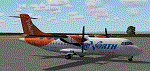
Textures for OSP ATR 42-300 depicting C-FVGF operating for Yukon Air North.
| Filename: | Air_North_Canada_ATR_42300.zip |
| License: | Freeware, limited distribution |
| Added: | 24th June 2018, 00:44:08 |
| Downloads: | 403 |
| Author: | John Tennent |
| Size: | 1.21 MB |
| Category: Flight Simulator 2004 - Scenery | |
| Kasba Lake CJL8 Northwest Territories Canada |
|
Images related to this file:
File Description:
This is a sixth airfield with links to Lake Athabasca, which is in Alberta and Saskatchewan. Kasba Lake is some 135 miles northeast of Stony Rapids and is in the Northwest Territories. The airfield is owned and run by and for Kasba Lake Lodge and it is one of several fishing vacation spots that are serviced by flights from Stony Rapids. It is these flights to the north that explain the number of regular scheduled flights into Stony Rapids from the south. The Kasba Lake Lodge has docks for boats and also for clients that want to arrive in their own floatplanes. The ai is for both Kasba Lake and Obre Lake and replaces the porpoising plane that I had used for Obre Lake. Norilor flies the weekend package-deal-long-distance delivery flights for Kasba Lake direct from Winnipeg, and now also for Obre Lake.
| Filename: | Kasba_Lake_CJL8_Northwest_Territories_Canada.zip |
| License: | Freeware, limited distribution |
| Added: | 9th August 2018, 14:21:17 |
| Downloads: | 149 |
| Author: | Roger Wensley |
| Size: | 2.48 MB |
| Category: Flight Simulator 2004 - Scenery | |
| Akulivik CYKO in northern Quebec Canada |
|
Images related to this file:
File Description:
This is another of the many airfields that are all around the coast of Hudson Bay, this one being on the eastern, Quebec side. Akulivik is around 110 miles south of Ivujivik, which is on the northeastern corner of the Bay, and some 60 miles north of Puvirnituq. The population is 630 or so and the village grew from a move back to the area by one family in 1973, followed by others in the following years; the closure of the Hudson Bay trading post post in 1952 had pushed all residents to move south to Puvirnituq. The village is unusual in that it has a built harbour instead of the usual beached storage of boats. The village is built on the central prong of a three pronged spear of headlands (from which the village name is derived) while the airfield is a mile or so further inland. I have no information regarding what I think may be a new terminal building, so this includes only the old original one. The runway is just under 3,500 feet of gravel aligned 09-27, and the ai includes the scheduled flight by an Air Inuit Dash 8-300, plus GA.
| Filename: | Akulivik_CYKO_in_northern_Quebec_Canada.zip |
| License: | Freeware, limited distribution |
| Added: | 9th September 2018, 03:43:25 |
| Downloads: | 162 |
| Author: | Roger Wensley |
| Size: | 4.69 MB |
| Category: Flight Simulator 2004 - Scenery | |
| Aupaluk CYLA in northern Quebec Canada |
|
Images related to this file:
File Description:
This is a very small village in northern Quebec, on the eastern shore of Nunavik in Ungava Bay. The population is only around 200. The name refers to the redness of the iron bearing soil. Kuujuaq, the regional centre, is 90 miles to the south, and there are regularly scheduled flights by an Air Inuit Twin Otter. The runway is 3,400 feet of gravel aligned 05-23. The ai was included with the posting of Akulivik but is included again here.
| Filename: | Aupaluk_CYLA_in_northern_Quebec_Canada.zip |
| License: | Freeware, limited distribution |
| Added: | 18th September 2018, 04:22:22 |
| Downloads: | 127 |
| Author: | Roger Wensley |
| Size: | 2.41 MB |
| Category: Flight Simulator X - Aircraft Repaints, Textures and Modifications | |
| Air Canada Lockheed L-1011 TriStar |
|
Images related to this file:
File Description:

Lockheed L-1011 TriStar Air Canada, with 5 variations, utilizing the freeware L-1011 model by Thomas Ruth/Eric Cantu. Specialized installation instructions are included with this readme. This package also includes an updated VC texture that is more realistic for the L-1011 (removes the DC-10 emblem from the yoke). Base model and paint kit by Thomas Ruth/Eric Cantu, repaint by Michael Pearson.
| Filename: | Air_Canada_Lockheed_L1011_TriStar.zip |
| License: | Freeware |
| Added: | 23rd September 2018, 03:07:44 |
| Downloads: | 566 |
| Author: | Michael Pearson |
| Size: | 10.74 MB |
| Category: Flight Simulator 2004 - Scenery | |
| Thompson CYTH in northern Manitoba, Canada |
|
Images related to this file:
File Description:
Thompson is a city with around 13,000 inhabitants, located in northern Manitoba beside the Burntwood River. It serves as the administration centre for a large area of Manitoba and has industrial activities centred around mining and the processing of mined products. The version of the airport upon which this modification is based is the original posting in 2004 by CanUK Scenery. I would have made new buildings and a totally new scenery but I have the same problem as Sid and Pete in their later Thompson scenery: almost no photos!?! The update modifies the short end of the mainly gravel runway to asphalt (it was upgraded because it is regularly used as a taxiway) and also adds a later (2010?) gravel taxiway. The other ground modifications add allocated parking spots for fire fighting CL415 planes that are in the new AI, plus a lot more ga parking. You should already have some AI that includes Calm Air to see CYTH as it really is, the HQ of Calm Air. There are other additions including car parks and the usual sundry bits and pieces that inhabit every airfield. The CL415's with Manitoba textures are adaptations of what were originally Ontario planes and included with my post of Geraldton, not the most recent post in 2013, the one in 2007. If you don't have the planes get them from my Geraldton post. The AI version was made from the original piloted version which was by Massimo Taccoli. The AI helicopter was included in my post of Alma CYTF.
| Filename: | Thompson_CYTH_in_northern_Manitoba_Canada.zip |
| License: | Freeware, limited distribution |
| Added: | 23rd September 2018, 15:24:22 |
| Downloads: | 225 |
| Author: | Roger Wensley |
| Size: | 6.4 MB |
| Category: Flight Simulator 2004 - Scenery | |
| Golden CYGE in British Columbia, Canada |
|
Images related to this file:
File Description:
This airfield is in one of the north-south valleys in the Columbia Mountains (which are part of the Rockies) on the border between BC and Alberta. The town of Golden (population just under 4,000) grew along with the Canadian Pacific Railway and the logging industry, both of which are still the mainstays of the town. Tourism is a more recent development along with the Kicking Horse Mountain Resort, which is only 3 miles to the west of the town. There are occasional flights into CYGE related to the richer echelon of tourist groups for Kicking Horse, particularly at the weekends; three actual such flights are included in the AI. Golden CYGE is immediately to the west of the town beside the Columbia River, with the 4,500 feet of asphalt runway aligned 14-32; right hand circuits for 32. There are no runway lights or landing aids, and no taxiway lights, so this airfield is for daylight use only. There is a helicopter company based on the field (Alpine) and a volunteer search and rescue group, a skydiving operation at the northern end, plus an active club with a long open hangar with a club room. A friendly airfield. The AI helicopter was included in my post of Alma CYTF. The Beaver will not show up unless you have the Aerosoft Beaver installed. I found the other planes without a problem on flightsim or avsim. Due to the surrounding terrain AI aircraft will usually impact high ground before landing and then just show up on their parking spots. A northern wind improves but does not totally solve this.
| Filename: | Golden_CYGE_in_British_Columbia_Canada.zip |
| License: | Freeware, limited distribution |
| Added: | 29th September 2018, 19:26:13 |
| Downloads: | 156 |
| Author: | Roger Wensley |
| Size: | 12.2 MB |
| Category: Flight Simulator 2004 - Scenery | |
| Bar River CPF2 in Ontario, Canada |
|
Images related to this file:
File Description:
Bar River is an airfield in Ontario, some 20 miles east of Sault Ste Marie. It is owned and operated by Springer Aerospace, an aircraft maintenance company. They specialise in turboprop aircraft and carry out work for several northern airlines plus private owners; they also have a paintshop and have painted planes for a number of airlines including Air Canada. There used to be two runways but one is now only a taxiway and the one remaining is aligned 36-18 and 4,415 feet long. Adjacent to this runway is "the ditch", a 2,000 feet long water runway; there is no way put of the ditch except by fork lift or by take off. In the winter a number of float planes are stored on the airfield for maintenance until the flying season opens again. There are no runway or taxiway lights, and no signage. There is a windsock.
| Filename: | Bar_River_CPF2_in_Ontario_Canada.zip |
| License: | Freeware, limited distribution |
| Added: | 14th August 2018, 21:31:58 |
| Downloads: | 115 |
| Author: | Roger Wensley |
| Size: | 18.44 MB |


© 2001-2026 AVSIM Online
All Rights Reserved
Privacy Policy |