
Where Flight Simulation Enthusiasts Gather from Around the World!
AVSIM Library - Search Results

| Category: Flight Simulator 2004 - AI Aircraft | |
| Air Canada Boeing 787-8 |

|
Images related to this file:
File Description:

FS2004 CamSim AI Aircraft, Boeing 787-8 Air Canada textures only, including the night textures, to be used with CamSim AI Aircraft Base Model files package available separately: camsim788ai_9.zip for AI traffic. Model design and paint by Camil Valiquette.
| Filename: | Air_Canada_Boeing_7878.zip |
| License: | Freeware |
| Added: | 4th November 2014, 19:42:08 |
| Downloads: | 681 |
| Author: | Camil Valiquette |
| Size: | 1.57 MB |
| Category: Flight Simulator 2004 - Scenery | |
| Edson CYET in Alberta, Canada |
|
Images related to this file:
File Description:
Edson is 120 miles west of Edmonton in Alberta, on Highway 16. It was originally named Heatherwood, but that was changed to honour the vice president of the Grand Trunk Pacific Railway when it was made the local railway centre. It thrived, and when Highway 16 was upgraded it thrived even more. Coal mining and industry connected with timber are the main employers of a population of around 8,500. The airport is at the western edge of the town at 3,041 feet asl, with a single lit runway 6,000 feet long and 100 feet wide aligned 07-25, with displaced thresholds and VASI at each end. The two joined aprons are at the eastern end of the airfield, with fire fighting chemical tanks beside the western one which is reserved in the summer months for the Lockheed Electra Air Spray planes; these are included in the AI. The eastern apron is for visiting charters and GA planes, next to a small terminal building. There is further parking on the grass for resident planes next to a large gravel car parking area and clubhouse. As the Air Spray planes would not be fighting fires in the winter there are in fact two editions of the AI, one for the summer fire fighting season and the other for the winter freeze. Use whichever one is appropriate for your flight time; I never strayed far from Ottawa in the winter so for me it is the summer one only. While making this I came across something new in the shape of some incorrectly installed edge lights in the stock fs9 version that refused to be deleted. There is still an "Edson TOP" folder which would normally be used to delete all unwanted taxiway edge lights, but in this case it deletes only some of them. Apologies, but there is nothing more that I can do and so I suggest you use this in daylight only.
| Filename: | Edson_CYET_in_Alberta_Canada.zip |
| License: | Freeware, limited distribution |
| Added: | 10th February 2019, 23:59:04 |
| Downloads: | 148 |
| Author: | Roger Wensley |
| Size: | 7.14 MB |
| Category: Flight Simulator X - Aircraft Repaints, Textures and Modifications | |
| Air Canada Boeing 737-700 |
|
Images related to this file:
File Description:
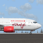
AIR CANADA Rouge texture set for the TDS Boeing 737-700 (not included, must download base package). Model developed by Tenkuu Developers Studio, features high resolution textures, dynamic flexing wings, nose gear steering, rudder lock, ground spoilers, low speed aileron locks at high speed, fully animated control surfaces, fully independent suspension, trim animation, opening passenger doors, rolling wheels, animated thrust reversers with reverser block doors, detailed textures, full night lighting, ground service vehicles and more. Model design by Hiroshi Igami. Flight dynamics design by Nick Wilkinson, with assistance from David Biggar. Master textures and paint kit by Kyle Schurb. Painted by Triadi Sudarmawan for the great TDS model. Also works in FS2004.
| Filename: | Air_Canada_Boeing_737700.zip |
| License: | Freeware |
| Added: | 13th November 2013, 22:05:00 |
| Downloads: | 776 |
| Author: | Triadi Sudarmawan |
| Size: | 2.53 MB |
| Category: Flight Simulator 2004 - Scenery | |
| Deline CYWJ - Northwest Territories, Canada |
|
Images related to this file:
File Description:
This is the third in a series of airfields that follow in a southward direction that early access route to the Canadian northern shore, the Mackenzie River. Deline is south of Tuktuk, Inuvik, Fort McPherson, and Fort Good Hope, all already posted. Deline is at 704 feet asl and around 50 miles east of the the Mackenzie, where the Great Bear River flows out of the western end of Great Bear Lake on its way to the Mackenzie. This lake is huge. The town of Deline has a population of around 500, and the first trading post (of the North West Company) was established there as early as 1799. The Hudson Bay Company opened an outpost in 1825 to support the Franklin Arctic Exploration expedition, and it was then called Fort Franklin. The name was changed to Deline in 1993. The airport is just over a mile north of the town, and has almost 4,000 feet of gravel runway. There is no fuel available. The original airfield is still visible just to the north of the town, from before it was rebuilt on higher ground (better drainage) and away from the houses. AI will follow with later posts.
| Filename: | Deline_CYWJ__Northwest_Territories_Canada.zip |
| License: | Freeware, limited distribution |
| Added: | 5th July 2014, 14:47:36 |
| Downloads: | 241 |
| Author: | Roger Wensley |
| Size: | 2.54 MB |
| Category: Flight Simulator 2004 - Scenery | |
| Wrigley CYWY - Northwest Territories, Canada |
|
Images related to this file:
File Description:
Wrigley is the next in a series of airfields that follow (approximately) in a southward direction that early access route to the Canadian northern shore, the Mackenzie River. At the far northern end there is Tuktoyaktuk, then Inuvik, Fort McPherson, Fort Good Hope, and Deline, all posted. Wrigley is at 489 feet asl and on the east bank of the the Mackenzie, around 135 miles due south of Deline. The town of Wrigley has a population of only 125 or so folks, and was relocated to its current position in 1965 from Fort Wrigley to be near the WW2 era airfield; I have no idea where Fort Wrigley is, or was. The airport is just over a mile south of the town, and has 3,500 feet of gravel runway. North Wright Air have scheduled flights to here and other airfields up and down the Mackenzie (including Deline, Fort Simpson, and Fort Good Hope etc) which is reflected in the revised AI. There is again a mandatory radio frequency but I have set the "tower" as unmanned so you will announce intentions and join downwind. There is no fuel available.
| Filename: | Wrigley_CYWY__Northwest_Territories_Canada.zip |
| License: | Freeware, limited distribution |
| Added: | 5th July 2014, 21:01:37 |
| Downloads: | 212 |
| Author: | Roger Wensley |
| Size: | 3.81 MB |
| Category: Flight Simulator X - Scenery | |
| CYVO - Val-d'Or, Quebec, Canada |
|
Images related to this file:
File Description:

Realistic scenery of CYVO Val-d'Or regional airport (in western Quebec). Main buildings, many static aircrafts, vehicules and... caribous!
| Filename: | CYVO__ValdOr_Quebec_Canada.zip |
| License: | Freeware |
| Added: | 19th May 2014, 10:19:13 |
| Downloads: | 2,018 |
| Author: | Jean-Pierre Fillion |
| Size: | 11.49 MB |
| Category: Flight Simulator 2004 - Scenery | |
| CZFN - Tulita - Northwest Territories, Canada |
|
Images related to this file:
File Description:
Tulita (Fort Norman until 1996) is another in the series of airfields that follow (approximately) the Mackenzie River. At the far northern end of the river and on the eastern side of the delta there is Tuktoyaktuk, then Inuvik, Fort McPherson, Fort Good Hope, Deline, Wrigley, Fort Simpson Island and Fort Simpson, and then Fort Liard at the southern end of the list of those in the Northwest Territories. South of Fort Liard there are Peace River and Dawson Creek, both of which are already posted. Tulita is at the junction of the Mackenzie and Great Bear Rivers, on the east bank of the Mackenzie and the south bank of the Great Bear, around 40 miles southeast of Norman Wells. The town has a population of about 480 folks. The airport is above and to the east of the town, and has 3,000 feet of gravel runway. The scheduled flights are by North Wright and I have also added a Buffalo DC3 and GA. There is a mandatory radio frequency but in this case I have set the "tower" to "unmanned" so you will report position and intentions. There is no fuel available.
| Filename: | CZFN__Tulita__Northwest_Territories_Canada.zip |
| License: | Freeware, limited distribution |
| Added: | 12th July 2014, 08:05:54 |
| Downloads: | 272 |
| Author: | Roger Wensley |
| Size: | 2.66 MB |
| Category: Flight Simulator X - Scenery | |
| CYFB - Iqaluit Airport - Nunavut, Canada |
|
Images related to this file:
File Description:
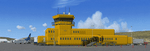
Iqaluit is the capital of Nunavut, a vast northern region that covers almost all of the Canadian North. The airport is of critical importance to the community, especially when ice makes boat travel impossible.
The scenery includes all airport buildings with custom designed and generic buildings nearby. Several typical airlines are represented, both by their flights by their facilities, including First Air, Canadian North, Air Greenland, Ken Borek Air and Keewatin. The Airbus A380 was in Iqaluit in February 2006 for flight testing in cold weather, as do other manufacturers. Airbus will also carry out the same tests for its new A350.
CYFB is also a Canadian Force base. Several units are parked in the military area, in addition to the C- 177 and his escort on ramp 2. A Twin Otter from the RCMP, and some general aviation aircrafts complement the fleet. Six ships are in the scenery: four static and two mobile (AI). Zodiacs and a balloon tourist flow into the bay. These, and the ships AI, start their movements 1100Z. The weather station launches a weather balloon regularly. Three small caribou herds are in the vicinity.
| Filename: | CYFB__Iqaluit_Airport__Nunavut_Canada.zip |
| License: | Freeware, limited distribution |
| Added: | 5th April 2014, 14:37:23 |
| Downloads: | 3,969 |
| Author: | Jean-Pierre Fillion, Pierre Gallant |
| Size: | 16.88 MB |
| Category: Flight Simulator X - AI Aircraft | |
| Air Canada Boeing 747-400 |
|
File Description: This is an AI Aardvark Boeing 747-400, Just drop the file ''adv b744 aca'' in
to your aircraft selection folder. Pls read the README.txt for more information.
For FS9/FSX.
| Filename: | Air_Canada_Boeing_747400.zip |
| License: | Freeware |
| Added: | 7th May 2014, 20:12:33 |
| Downloads: | 386 |
| Author: | Hans Timothy |
| Size: | 1.59 MB |
| Category: Flight Simulator 2004 - Scenery | |
| CYQU - Grande Prairie, Alberta, Canada |
|
Images related to this file:
File Description:
Grande Prairie is at 2,195 feet asl, 65 miles southeast of Dawsons Creek, 90 miles southwest of Peace River and around 60 miles east of the Rockies. The town has a population of 55,000 and growing. The airport is just to the west of the town and was originally a military base, built during WW2. The two runways are 07-25 and 11-29 and when one is the active runway then the other is used as a taxiway. AI in FS9 doesn't like this, and just stops at the first hold short without ever reaching the active runway. I have found a way to overcome this and AI will now use taxiway A and whichever runway is inactive to feed to and from both ends of the active runway. The vertical red tanks are for de-icing fluid; de-icing is carried out before take-off in the winter. The industrial area to the southeast is now larger than I have made it, but I kept it to this minimum size to keep frame rates down. All the buildings are modeled specifically for CYQU. The AI includes Westjet, Air Canada Jazz, and others as listed. The GA AI uses only FS9 standard aircraft.
| Filename: | CYQU__Grande_Prairie_Alberta_Canada.zip |
| License: | Freeware, limited distribution |
| Added: | 9th May 2014, 10:05:40 |
| Downloads: | 670 |
| Author: | Roger Wensley |
| Size: | 18.33 MB |


© 2001-2026 AVSIM Online
All Rights Reserved
Privacy Policy |