
Where Flight Simulation Enthusiasts Gather from Around the World!
AVSIM Library - Search Results

| Category: Flight Simulator 2004 - Scenery | |
| CPR5 - Woodstock - Ontario, Canada |

|
Images related to this file:
File Description:
This is the first of a south Ontario series. Woodstock is a town with a population of around 38,000, located 50 miles west of Lake Ontario. The airfield is 3 miles west of the town, with a single grass runway just over 3,000 feet long and 100 plus feet wide, aligned 05/23 in FS9 (in fact it is now 06/24 due to the magnetic north wandering off during the last 10 years). There have been at different times varying amounts of gravel mixed in with the grass on both runway and taxiway; the majority surface by far is grass and I have left it all as such, as there is no visually convincing way to mix the two without unreal sharp edges. The apron is on the northern side of the runway, and is now modified in shape to maximise the area available for crops. There are 10 "T" hangars and a small clubhouse in a single long building. There is no fuel, runway lighting, or taxiway or apron lights so usage is effectively restricted to daylight hours. To the east of CPR5 and on the edge of the town is a private airstrip with 2,800 feet of asphalt runway; I have added this as a visual reference, along with several large grain silos on the other side of the road. Hidden in plain sight amid the surrounding farmland, the first sighting of CPR5 is actually always of the adjacent and far more visible buildings just to the east of the apron, which are owned by a company that deals with everything to do with boats, up to and including fishing gear. These have been included. As ditches cannot be effectively duplicated in FS9 I have included some fences which do not exist in real life, to give some needed visual clues.
| Filename: | CPR5__Woodstock__Ontario_Canada.zip |
| License: | Freeware, limited distribution |
| Added: | 8th July 2015, 13:36:05 |
| Downloads: | 186 |
| Author: | Roger Wensley |
| Size: | 5.57 MB |
| Category: Flight Simulator X - Scenery | |
| Cross Country Canada 2016 |
|
Images related to this file:
File Description:
FSX Scenery - This is a scenery for the relatively short hops from the east coast of Canada to the west coast. All files are included. See the readme file for information on each airport you'll be landing at. For your flying pleasure by John B. Loney, Jr.
| Filename: | Cross_Country_Canada_2016.zip |
| License: | Freeware, limited distribution |
| Added: | 26th March 2016, 11:53:03 |
| Downloads: | 1,153 |
| Author: | John B. Loney, Jr. |
| Size: | 202.69 MB |
| Category: Flight Simulator 2004 - Original Aircraft | |
| Air Canada Airbus A319-114 'Trans-Canada Air Lines' (iFDG) |
|
File Description: iFDG A319 iFDG is proud to present the Airbus A319. The aircraft model includes most of the standard features including animated control surfaces, wingviews, flaps, full lighting configuration, highly detailed, reflective textures, and dynamic shine. This example is painted in the Trans-Canada Air Lines retro scheme of Air Canada (C-FZUH).

| Filename: | Air_Canada_Airbus_A319114_TransCanada_Air_Lines_iF.zip |
| License: | Freeware |
| Added: | 25th July 2004, 23:42:00 |
| Downloads: | 8,257 |
| Author: | iFDG, Clemens Pieper |
| Size: | 6.34 MB |
| Category: Flight Simulator 2004 - Scenery | |
| Cape Dyer CWFD in Nunavut, Canada |
|
Images related to this file:
File Description:
Cape Dyer is on the southeast corner of Baffin Island, around 120 miles east of Pangnirtung at approximately N66 45 W61 30. There is a fine view north up the Davis Strait between Baffin Island and Greenland, and this is the whole reason for the airfield's existance as it was built to support the construction and operation of a DEW line radar station, which has now been updated to a North Warning System site. There are two camps; the upper camp is on the east side of the Cape and is where the radars are located, linked by a gravel road to the lower camp, which is on the west and more sheltered side of the Cape on the clifs above Sunneshine Fjord. The runway is 5,000' of 150' wide gravel, and it is lighted and at 1,320' feet ASL. Cape Dyer is now listed as abandoned in the Canada Flight Supplement. It is, however, still there and presumably is still used for access to the North Warning System equipment, which is automated and generally unmanned. The buildings were modeled for this scenery and include a hanagar large enough to accommodate a C-130. Ultimate Terrain is not required as it does not cover northern Canada.
| Filename: | Cape_Dyer_CWFD_in_Nunavut_Canada.zip |
| License: | Freeware, limited distribution |
| Added: | 21st June 2011, 19:30:07 |
| Downloads: | 488 |
| Author: | Roger Wensley |
| Size: | 1.9 MB |
| Category: Flight Simulator X - Aircraft Repaints, Textures and Modifications | |
| Wien Consolidated '1970' Fokker F-27B |
|
Images related to this file:
File Description:

This is a repaint of the F-27B in Wien Consolidated 1970 colors. The freeware CalClassic F-27 by Tom Gibson and Bernward Bockheim is needed for this repaint. It was repainted using Bjoern Kesten's paintkit. Wien Air Alaska was known as Wien Consolidated after their merge with Northern Consolidated Airlines from 1967 through to 1973 when they reverted back to Wien Air Alaska. Wien operated 6 Fairchild F-27s over the years; 3 F-27As and 3 F27Bs. This repaint was tested on FSX-SE. Textures are 32bit. It should work on FS2004,FSX, & P3D v1-3.
| Filename: | Wien_Consolidated_1970_Fokker_F27B.zip |
| License: | Freeware |
| Added: | 3rd September 2018, 04:43:47 |
| Downloads: | 107 |
| Author: | Ted Giana |
| Size: | 3.15 MB |
| Category: Prepar3D V1-4 - Aircraft Repaints, Textures and Modifications | |
| Lockheed L-049 Constellation (N7777G) Fly Alaska |
|
Images related to this file:
File Description:
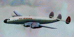
This folder contains a repaint for the A2A Lockheed L049 Constellation in the colors of N7777G of Fly Alaska. N7777G was a L749 that first flew with KLM as PH-TET. It flew with Wien Alaskan Airlines between 1964 and 1968 before going to Fly Alaska. In 1973 it was used by the Rolling Stones for their Far East Tour. It then went to Lanzair and was abandoned in Dublin in 1974. It has been on display in the Science Museum at Wroughton since 1983. Repaint by Jan Kees Blom, based on the paintkit by A2A.
| Filename: | Lockheed_L049_Constellation_N7777G_Fly_Alaska.zip |
| License: | Freeware |
| Added: | 30th September 2018, 23:14:43 |
| Downloads: | 285 |
| Author: | Jan Kees Blom |
| Size: | 21.8 MB |
| Category: Flight Simulator 2002 - Scenery | |
| Baghdad City Centre PhotoScenery |
|
File Description:
Based on 2.4M resolution image of baghdad city centre, Feb 6th 2002. Image displays in FS2002 at resolution limited by terrain engine.
Fly Baghdad as it was before the war.
1 season only. No night texture.
*Image courtesy of DigitalGlobe, www.digitalglobe.com *
| Filename: | Baghdad_City_Centre_PhotoScenery.zip |
| License: | Freeware |
| Added: | 13th April 2003, 18:35:19 |
| Downloads: | 2,027 |
| Author: | Neil Cooke |
| Size: | 6.14 MB |
| Category: Flight Simulator 2004 - Scenery | |
| New Detail Texture |
|
File Description:
Upgraded detail texture for FS9:COF, it should also work with FS2002. Works great for low flying in rural areas, less so for cities (acceptable though). Also improves texture on distant terrain/mountains. More repetitive than the standard detail texture.
| Filename: | New_Detail_Texture.zip |
| License: | Freeware, limited distribution |
| Added: | 6th December 2003, 07:25:53 |
| Downloads: | 1,416 |
| Author: | Daniel Buechter |
| Size: | 193.77 KB |
| Category: Flight Simulator 2004 - Scenery | |
| Tomar airfield, Portugal |
|
Images related to this file:
File Description:
Valdonas airfiel, near Tomar city, close to center of Portugal. This rwy is to be asphalted in a near future and his home of Associacao Tomarense de Aviacao Ultraligeira. This scenery is fully compatible with PTSIM Portugal Terrain (http://www.ptsim.com).
| Filename: | Tomar_airfield_Portugal.zip |
| License: | Freeware |
| Added: | 12th December 2009, 15:56:22 |
| Downloads: | 490 |
| Author: | Joao A. Graca Ferreira |
| Size: | 2.27 MB |
| Category: Flight Simulator 2004 - Scenery | |
| Suisse 2004 VFR Addition |
|
Images related to this file:
File Description:
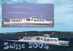
Adds a lot of VFR objects every where in Switzerland to make your VFR flights more realistic : atomic plants, antennas, boats on the lakes. May have some error with Ultimate Terrain (not tested). Works perfectly in FS2002 too. Re-upload.
| Filename: | Suisse_2004_VFR_Addition.zip |
| License: | Freeware |
| Added: | 10th June 2010, 09:20:29 |
| Downloads: | 16,513 |
| Author: | Daniel Gauthier |
| Size: | 4.54 MB |


© 2001-2026 AVSIM Online
All Rights Reserved
Privacy Policy |