
Where Flight Simulation Enthusiasts Gather from Around the World!
AVSIM Library - Search Results

| Category: Flight Simulator 2004 - Scenery | |
| New Terrain Mesh of the Province of Quebec in LOD09 (4/4) |

|
File Description:
The files in this package contain terrain mesh files of the province of Quebec (N45 to N53) to be used with my Quebec enhanced sceneries for FS2004 (Scenes_du_Quebec_2k4.zip). The public data sources are the Shuttle Radar Topography Mission (SRTM-3, 90m) and the Canadian Digital Elevation Data (CDED - 0.75s/arc - 23m). (QC09_2k4a.zip to QC09_2k4d.zip - 4 parts)
***********************
Les fichiers de ces archives contiennent les donnees d'elevation de terrain (mesh files - lod09), pour FS2004, du territoire de la province de Quebec sous le 53ieme degre de latitude nord. Ils ont ete crees pour etre utilises avec mes nouvelles scenes du Quebec contenues dans Scenes_du_Quebec_2k4.zip. Les donnees sources sont du domaine public et proviennent de la Shuttle Radar Topography Mission (SRTM-3, 90m) et des donnees numerique d'elevation du Canada (DNEC - 0.75s/arc -23 m). (QC09_2k4a.zip to QC09_2k4d.zip - 4 parties)
| Filename: | New_Terrain_Mesh_of_the_Province_of_Quebec_in_LOD0.zip |
| License: | Freeware, limited distribution |
| Added: | 27th January 2010, 18:17:08 |
| Downloads: | 7,859 |
| Author: | Gilles Gauthier |
| Size: | 20.94 MB |
| Category: Flight Simulator 2004 - Scenery | |
| Washington Lighthouse Update |
|
File Description:
This update will relocate 5 of the Washington Lighthouses to use the changes in the FSGenisis West Coast Terrain version 3.0. It isn't needed if you don't have FSGenisis installed. It has not been tested with any other "terrain mesh".
Install assumes you have already installed the complete Washington Lighthouse collection, WA_lighthouse.zip.
| Filename: | Washington_Lighthouse_Update.zip |
| License: | Freeware |
| Added: | 29th November 2003, 01:55:09 |
| Downloads: | 2,285 |
| Author: | Larry Silsbee |
| Size: | 82.75 KB |
| Category: Flight Simulator 2004 - Scenery | |
| LOD10 (38-m) Glacier Bay National Park, Alaska |
|
File Description:
This LOD10 (38-m) add-on mesh of Glacier Bay National Park and the adjacent Lynn Canal area between Juneau and Skagway (N58-60 W134-138) is an optional (!) upgrade of gl_bay_1.zip (by Holger Sandmann and Jim Keir). It adds more detail to the mountainous areas and allows to locally override other installed Alaska add-on meshes without having to deactivate them. The USGS NED seamless digital elevation data used for this mesh have a 2-arcsec (~60-m) resolution. Thus, the compilation as LOD10 (38-m) will reveal all terrain details contained in the source data. Please read the gl_bay_1.zip read-me file for further information about the special features of the Glacier Bay Project.
| Filename: | LOD10_38m_Glacier_Bay_National_Park_Alaska.zip |
| License: | Freeware, limited distribution |
| Added: | 16th February 2004, 03:40:57 |
| Downloads: | 8,595 |
| Author: | Holger Sandmann |
| Size: | 24.98 MB |
| Category: Flight Simulator 2004 - Aircraft Repaints, Textures and Modifications | |
| FS2004 Canadian Forces CH149 Cormorant |
|
File Description:
Canadian Forces CH149 Cormorant. Textures
only. A repaint of Philip Chandler's GMAX
EH101 Merlin in the color scheme of
442(T&R) Squadron based at CFB Comox BC
Canada. Requires merlinhm.zip and the update
merlin11.zip. See Readme file for panel and
sound recommendations and were to find them.
| Filename: | FS2004_Canadian_Forces_CH149_Cormorant.zip |
| License: | Freeware, limited distribution |
| Added: | 2nd November 2005, 02:44:28 |
| Downloads: | 1,020 |
| Author: | Vern Opperman |
| Size: | 236.88 KB |
| Category: Flight Simulator 2004 - Aircraft Repaints, Textures and Modifications | |
| West Coast Air de Havilland Canada DH6 Twin Otter |
|
File Description:
Repaint for Lago DH6 twin otter. Textures only. West Coast air is A locally owned and operated airline with more than 35 years of Twin Otter scheduled service experience. West Coast Air offers up to 40 Twin Otter departures daily between downtown Vancouver and downtown Victoria (Canada, BC).
| Filename: | West_Coast_Air_de_Havilland_Canada_DH6_Twin_Otter.zip |
| License: | Freeware |
| Added: | 23rd March 2008, 14:51:53 |
| Downloads: | 174 |
| Author: | Ruud Scholte |
| Size: | 785.46 KB |
| Category: Flight Simulator 2004 - Aircraft Repaints, Textures and Modifications | |
| DH6 Twin Otter old logo |
|
File Description:
Repaint for Lago DH6 twin otter. Textures only. West Coast air is A locally owned and operated airline with more than 35 years of Twin Otter scheduled service experience. West Coast Air offers up to 40 Twin Otter departures daily between downtown Vancouver and downtown Victoria (Canada, BC).
| Filename: | DH6_Twin_Otter__old_logo.zip |
| License: | Freeware |
| Added: | 26th March 2008, 21:23:01 |
| Downloads: | 146 |
| Author: | Ruud Scholte |
| Size: | 829.93 KB |
| Category: Flight Simulator X - Aircraft Repaints, Textures and Modifications | |
| Pacific Coastal Grumman Goose (C-FHUZ) |
|
Images related to this file:
File Description:
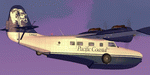
This folder contains a repaint for the Grumman Goose Redux, available at OZx, in the colors of Grumman Goose G-21A c/n B-83 C-FHUZ of Pacific Coastal, Richmond, BC, Canada, built in 1944. Repaint by Jan Kees Blom, based on the paintkit by the OZx team.
| Filename: | Pacific_Coastal_Grumman_Goose_CFHUZ.zip |
| License: | Freeware |
| Added: | 11th July 2018, 17:13:54 |
| Downloads: | 192 |
| Author: | Jan Kees Blom |
| Size: | 22.48 MB |
| Category: Microsoft Flight Simulator (2020) - Aircraft Repaints, Textures and Modifications | |
| Grumman Goose (C-FUAZ) Pacific Coastal |
|
Images related to this file:
File Description:
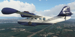
This folder contains a repaint for the Grumman Goose for MSFS2020, available at sim-outhouse.com, in the colors of Grumman Goose c/n 1077 C-FUAZ of Pacific Coastal, Richmond, BC, Canada, built in 1940. Repaint by Jan Kees Blom, based on the paintkit by the OZx team.
| Filename: | Grumman_Goose_CFUAZ_Pacific_Coastal.zip |
| License: | Freeware |
| Added: | 2nd January 2021, 18:55:23 |
| Downloads: | 47 |
| Author: | Jan Kees Blom |
| Size: | 54.75 MB |
| Category: Flight Simulator 2004 - Scenery | |
| FYSM Swakopmund, Namibia for FS9 |
|
File Description:
Based on googleEarth and fotos. Ez-scenery and rwy12 objects included. Compatible with Holger Sandmann's Namibia LOD9 Terrain mesh (namibia_ne.zip, namibia_nw.zip, namibia_se.zip, namibia_sw.zip, namibia_cp.zip) as well as his namibia_scenery_updates.zip, all found at avsim.com.
| Filename: | FYSM_Swakopmund_Namibia_for_FS9.zip |
| License: | Freeware |
| Added: | 12th December 2008, 23:26:45 |
| Downloads: | 1,036 |
| Author: | Detlev J. Rohmer |
| Size: | 10.92 MB |
| Category: Flight Simulator 2004 - Scenery | |
| Canyon Lake Camps |
|
File Description:
These little camps in the Bell Island, Alaska area are the first in a group of fictional sceneries covering Southeast AK. Should work fine with or without Eddy Denny's terrain mesh. I hope you enjoy them as much as I have.
Menu entries on the Add-on Scenery menu will get you to the starting points. Requires trees_v3 from Garrish Gray. Each includes a beach and water start. They make for nice hops to deliver hunters, fisherman, tourists, and supplies from Wrangell, or Ketchikan, AK.
| Filename: | Canyon_Lake_Camps.zip |
| License: | Freeware |
| Added: | 16th January 2004, 21:06:01 |
| Downloads: | 2,197 |
| Author: | Todd Hudgel |
| Size: | 1.56 MB |


© 2001-2026 AVSIM Online
All Rights Reserved
Privacy Policy |