|
AVSIM Library - Search Results
|
|
Login | Register | About logging in and out
|
|
Searching for: 'utah' in Flight Simulator 2004 - Scenery and below.
|

|
|
|
|
|
|
Images related to this file:
|
File Description:
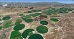
Mormon Range, Enterprise, Beryl (UT82), Utah, Photo-Scenery (FS9 & FSX)
This scenery covers the area of just north of St. George (KSGU) north along the Mormon Range and Enterprise to Beryl (UT82). It completes the southwestern corner of Utah and paves our way into Nevada. High resolution versions of this scenery for FS9 and FSX (much sharper, but larger and multiple downloads)are available at www.blueskyscenery.com/CNY_South2West6.html . The screenies are taken from the high-res versions, so expect this version to be slightly more blurry.
Thanks to Joop Mak for providing a custom AFCADs that correct airport layouts so that they align with the photo-textures! They are available at www.blueskyscenery.com/AFCADs.html . YourDonation@Work: Dedicated to Jean Pierre, Konrad and Juan.
|
| Filename: |
cny_south2west6_2010_lr.zip |
| License: |
Freeware, limited distribution |
| Added: |
27th March 2010, 11:38:48 |
| Downloads: |
1342 |
| Author: |
Gottfried Razek, blueskyscenery.com |
| Size: |
99792kb |
|
|
Images related to this file:
|
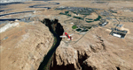
File Description:
This scenery covers the western part of Lake Powell, the city of Page (KPGA), the Vermillion Cliffs, Glenn Canyon just south of Glenn Canyon Dam, the northern part of Marble Canyon, Paria Canyon, Cockscomb, etc, etc. Spectacular! To explore the scenery depart from Page Municipal Airport (KPGA). High resolution versions of this scenery for FS9 and FSX (much sharper, but larger and multiple downloads) are available at www.blueskyscenery.com/CNY_South3West3.html . The screenies are taken from the high-res versions, so expect this version to be slightly more blurry. YourDonation@Work: Dedicated to William, Veit and Michele.
|
| Filename: |
cny_south3west3_2010_lr.zip |
| License: |
Freeware, limited distribution |
| Added: |
3rd March 2010, 21:26:32 |
| Downloads: |
1756 |
| Author: |
Gottfried Razek - blueskyscenery.com |
| Size: |
94625kb |
|
|
|
File Description:
This file will add the Eaglesoft Hanger, available here at AVSIM (esdghangerkit.zip), to the Provo, Utah airport (KPVU) if you have the ES Hanger Kit installed. Note: You MUST have the Eaglesoft Hanger Kit installed for this file to operate properly.
| Filename: |
kpvu.zip |
| License: |
Freeware |
| Added: |
11th April 2004, 06:39:40 |
| Downloads: |
523 |
| Author: |
Ken Scott |
| Size: |
53kb |
|
|
Images related to this file:
|
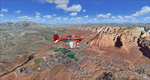
File Description:
Covers the area between St. George, Utah and Mesquite, Nevada. To the north of St. George
the Pine Valley Mountains with their foothills of scenic red sandstone loom over the city.
St. George Municipal Airport (KSGU) is mostly used for general aviation but is also served by SkyWest Airlines
on behalf of Delta Connection. Because of it's location on a mesa this airport can't be expanded and so a new
airport is currently being built southeast of the city at the site of an abandoned airfield. The opening
is expected in 2011. To the south of the city make sure, you don't miss the Virgin River Gorge where the
Virgin River winds thru a long winding canyon in the transition zone between the red rocks of southern Utahs
Colorado Plateau and Nevadas Mojave Desert. Shortly afterwards you reach Mesquite which is situated just
west of the Arizona stateline. Like nearly all Nevada cities near the stateline Mesquite is home to several
Casinos. Mesquite Airport (67L) lies just north of the city.
High resolution versions of this scenery for FS9 and FSX (much sharper, but larger and multiple downloads)
are available at www.blueskyscenery.com/CNY_South3West6.html . The screenies are taken from the high-res versions,
so expect this version to be slightly more blurry. Thanks to Joop Mak for providing custom AFCADs that
correct airport layouts so that they align with the photo-textures! They are available at www.blueskyscenery.com/AFCADs.html .
YourDonation@Work: Dedicated to Werner, Ralf-Peter and Nels.
|
| Filename: |
cny_south3west6_2010_lr.zip |
| License: |
Freeware, limited distribution |
| Added: |
24th March 2010, 19:41:43 |
| Downloads: |
1613 |
| Author: |
Gottfried Razek - blueskyscenery.com |
| Size: |
97874kb |
|
|
File Description:
I recently visited the St. George, Utah (KSGU) airport and discovered the beacon tower in a different location. This update places the tower in the correct position. Also I removed a couple of items that showed up if you are using the "very dense" scenery setting.
For UT users I updated the surrounding scenery to more resemble the actual area.
| Filename: |
ksgu_update.zip |
| License: |
Freeware |
| Added: |
22nd September 2008, 10:34:59 |
| Downloads: |
450 |
| Author: |
Alan C. Heiner |
| Size: |
8kb |
|
|
Images related to this file:
|
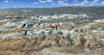
File Description:
The southern part of this region covers the Box-Death Hollow Wilderness, with its vertical gray-orange walls of Navajo sandstone. Then comes the Aquarius Plateau which is the highest timbered plateau in North America with Boulder Mountain. In the north you'll find the little town of Torrey, which is just eight miles west of Capitol Reef National Park. Extends my Grand Staircase Escalante scenery to the north.
High resolution versions of this scenery for FS9 and FSX (much sharper, but larger and multiple downloads) are available at www.blueskyscenery.com/CNY_SouthWest3.html . The screenies are taken from the high-res versions, so expect this version to be slightly more blurry.
Thanks to Joop Mak for providing a custom AFCADs that correct airport layouts so that they align with the photo-textures! They are available here: www.blueskyscenery.com/AFCADs.html . YourDonation@Work: Dedicated to Ralf-Peter, Jon and Laurent.
|
| Filename: |
cny_southwest3_2010_lr.zip |
| License: |
Freeware, limited distribution |
| Added: |
3rd April 2010, 00:52:09 |
| Downloads: |
1178 |
| Author: |
Gottfried Razek - blueskyscenery.com |
| Size: |
96041kb |
|
|
Images related to this file:
|
File Description:
Landclass Improvements for the USA, specialy the western part of the USA: Colorado, Utah, Yellowstone, little Part of Idaho, Montana and from LA to Seattle. This is a complete Update, please delete the old scenery folders.Udate: Utah+Colorado (changing urban forest LC to Crops +Fields), California Sierra Nevada LC9 changed to LC130 & some small Cities around KMMH/KBIH. The LC Scenery's are for further devolpment, including *.inf & *raw files.
|
| Filename: |
fs9-lcv1-4.zip |
| License: |
Freeware |
| Added: |
1st March 2015, 15:39:07 |
| Downloads: |
372 |
| Author: |
Markus Balz |
| Size: |
2473kb |
|
|
Images related to this file:

|
File Description:
Update: British Columbia, On the way to Misty Fjords,
a supplement for the area around Kewlona, Kamloop to Prinz Georg,
Frazer Plateau until the Borders of Misty Fjords. This is a complete update - no previous Versions are required.
Landclass Improvements for the USA, specialy the western Part of the USA: Colorado, Utah, Yellow Stone, little Part of Idaho, Montana and from LA to Seattle, Bristish Columbia and also some Testscenery's for the eastern Part of the USA (Arkansas KHOT and around KLWB).
|
| Filename: |
fs9-lcv2-1.zip |
| License: |
Freeware |
| Added: |
10th March 2015, 22:48:17 |
| Downloads: |
287 |
| Author: |
Markus Balz |
| Size: |
8397kb |
|
|
Images related to this file:

|
File Description:
Landclass improvements for the USA, specialy the western part of the USA:
Colorado, Utah, Yellowstone, part of Idaho, Montana and from LA to Seattle, Bristish Columbia and also some Testscenery's for the eastern part of the USA (Arkansas KHOT and around KLWB).
Update, simplification of scenery and batch (option) installation files.
|
| Filename: |
fs9-lcv2.zip |
| License: |
Freeware |
| Added: |
6th March 2015, 17:14:38 |
| Downloads: |
287 |
| Author: |
Markus Balz |
| Size: |
4125kb |
|
|

|
File Description:
This summer I have had to visit Utah beach in Normandy and some popultions of
special meaning in the allied landing of the D-Day He seen the hung parachutist of a needle of the steeple of Sainte Mere Eglise. The monument of Sainte Marie du Mont dedicated to the brave soldiers USA. The museum where memories of th landing are exhibited. In the exterior still stays some cars
Sherman,canyons and many things that you will discover if you stroll for the sourrunding.
This scenario contains one it lines from Mont Saint Michel-Coutances-Saint Lô-
Carentan- Sainte Marie du Mont-and finallt Utha beach. To the nord Cap la Hague.
166 populations they exist with it churchwa and castles. Three aeroports
aerodromes LFRC,LFRF and LFOM. See readme for more information
|
| Filename: |
utah_beach-normandy.zip |
| License: |
Freeware |
| Added: |
16th September 2011, 14:11:06 |
| Downloads: |
764 |
| Author: |
Toni Agramont |
| Size: |
45780kb |
|
  |


