|
AVSIM Library - Search Results
|
|
Login | Register | About logging in and out
|
|
Searching for: 'colorado' in Flight Simulator 2004 - Scenery and below.
|

|
|
|
|
|
|
Images related to this file:
|
File Description:
Covers the gap between my Leadville and Colorado Springs North sceneries and provides you with continuous coverage for longer cross country flights. High resolution versions of this scenery for FS9 and FSX (much sharper, but larger and multiple downloads) are available at www.blueskyscenery.com/GNB_South2.html . The screenies are taken from the high-res versions, so expect this version to be slightly more blurry. YourDonation@Work: Dedicated to Arthur and Pierre-Alain.
|
| Filename: |
gnb_south2_2010_lr.zip |
| License: |
Freeware, limited distribution |
| Added: |
3rd February 2010, 22:19:58 |
| Downloads: |
1390 |
| Author: |
Gottfried Razek - blueskyscenery.com |
| Size: |
91636kb |
|
|
File Description:
In Real Terrain Colorado you will see the mountains just west of Denver in very high detail. You can actually take off from Denver international and struggle to stay above the terrain as you fly into the mountains, that is if you are using a small aircraft like the Cessna 172SP Skyhawk. Also in Real Terrain Colorado, It Creates Very detailed valleys. It is very relaxing flying through the valleys during a nice sunny afternoon. Real Terrain Colorado is Split up into two Packs. You do not need to download both packs to enjoy this Scenery, buy it is Highly Recommended.
| Filename: |
rtcp1fs9.zip |
| License: |
Freeware |
| Added: |
23rd September 2003, 02:00:17 |
| Downloads: |
7849 |
| Author: |
David P Smith |
| Size: |
38925kb |
|
|
|
File Description:
The airport has been very a little change airport but the airport code has been revised from 0V2. Now, KANK is a new code. The two scenery enclosed KANK and 0V2. If without 0V2 ADE9 will cause view overlap from stock 0V2 old ones.
| Filename: |
kank.zip |
| License: |
Freeware |
| Added: |
24th June 2020, 18:02:25 |
| Downloads: |
105 |
| Author: |
Stuart John Gilbert II |
| Size: |
3958kb |
|
|
Images related to this file:
File Description:
FS2004 Scenery - San Luis Valley Regional/Bergman Field Airport serves Alamosa and Alamosa County and is owned by the City And County of Alamosa, Colorado, USA. The airport has more than one runway. The longest is a paved runway extending 8800 feet. The facility is at an elevation of 7535 feet at a distance of about 2 miles from Alamosa. The Airport (IATA: ALS, ICAO: KALS), also known as Bergman Field, is a public airport used for general aviation, but is also served by one commercial airline. Created with EZ Scenery. EZ Scenery libraries required. Scenery created over USA Roads. By John B. Loney, Jr.
| Filename: |
kals_v1.zip |
| License: |
Freeware, limited distribution |
| Added: |
23rd May 2010, 01:31:13 |
| Downloads: |
1017 |
| Author: |
John B. Loney, Jr. |
| Size: |
669kb |
|
|
Images related to this file:
File Description:
Santa's Sleigh & 8 Reindeer - AI Version.
It is rumored that Rudolph is ill and may not be able to lead the Reindeer this Christmas so Santa is making some test flights with just the original eight reindeer. He has chosen a remote airfield near Steamboat Springs, Colorado (81CO) named Mesa 1. Of course you can place this AI version at the location of your choice. I have taken the original flyable model by Dundee Prototypical Simulations (available here as santa.zip) and tweaked it for use as an AI craft, using parameters usually associated with Helicopters to let Santa practice shorter takeoffs and landings.
ALL necessary files are included. Please unzip to a temporary folder and follow the simple installation instructions. As a bonus, there is also a set of instructions showing how to set this up as a continuously running display on your screen - a nice option for the Holidays. Compiled for Kids of all ages by David "Opa" Marshall.
| Filename: |
ai_santa_and_sleigh.zip |
| License: |
Freeware |
| Added: |
2nd December 2009, 13:43:26 |
| Downloads: |
992 |
| Author: |
David "Opa" Marshall |
| Size: |
1061kb |
|
|
Images related to this file:
|
File Description:
Covers the area between St. George, Utah and Mesquite, Nevada. To the north of St. George
the Pine Valley Mountains with their foothills of scenic red sandstone loom over the city.
St. George Municipal Airport (KSGU) is mostly used for general aviation but is also served by SkyWest Airlines
on behalf of Delta Connection. Because of it's location on a mesa this airport can't be expanded and so a new
airport is currently being built southeast of the city at the site of an abandoned airfield. The opening
is expected in 2011. To the south of the city make sure, you don't miss the Virgin River Gorge where the
Virgin River winds thru a long winding canyon in the transition zone between the red rocks of southern Utahs
Colorado Plateau and Nevadas Mojave Desert. Shortly afterwards you reach Mesquite which is situated just
west of the Arizona stateline. Like nearly all Nevada cities near the stateline Mesquite is home to several
Casinos. Mesquite Airport (67L) lies just north of the city.
High resolution versions of this scenery for FS9 and FSX (much sharper, but larger and multiple downloads)
are available at www.blueskyscenery.com/CNY_South3West6.html . The screenies are taken from the high-res versions,
so expect this version to be slightly more blurry. Thanks to Joop Mak for providing custom AFCADs that
correct airport layouts so that they align with the photo-textures! They are available at www.blueskyscenery.com/AFCADs.html .
YourDonation@Work: Dedicated to Werner, Ralf-Peter and Nels.
|
| Filename: |
cny_south3west6_2010_lr.zip |
| License: |
Freeware, limited distribution |
| Added: |
24th March 2010, 19:41:43 |
| Downloads: |
1613 |
| Author: |
Gottfried Razek - blueskyscenery.com |
| Size: |
97874kb |
|
|
Images related to this file:
|
File Description:
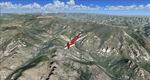
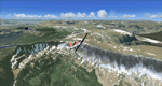
Steamboat Springs (KSBS), Flat Tops Wilderness Area, Colorado, Photo-Scenery (FS9 & FSX)
The Flat Tops Wilderness Area, which is the second largest wilderness area in Colorado, is named for its many flat topped mountains that are clearly visible from the sky. Trappers Lake, located in the north of the area inspired Arthur Carhart, a US Forest Service official, to initiate a plea for Wilderness preservation as early as 1919. Finally in 1975, three years before his death in 1978, the Flat Tops were designated a wilderness area. No wonder he found the area so entrancing: Behind Trappers Lake loom majestic volcanic cliffs, and beyond them a vast subalpine terrain reluctantly yields to alpine tundra with an average elevation of about 10.000 feet. More than 100 lakes dot the country above and below numerous flat-topped cliffs. Steamboat Springs is an internationally known winter resort destination.
To explore the scenery depart from Steamboat Springs Airport (KSBS) or Yampa Valley Airport (KHDN) and head south. High resolution versions of this scenery for FS9 and FSX (much sharper, but larger and multiple downloads) are available at www.blueskyscenery.com/GNB_West2.html . The screenies are taken from the high-res versions, so expect this version to be slightly more blurry. Thanks to Joop Mak for providing custom AFCADs that correct airport layouts so that they align with the photo-textures! They are available at www.blueskyscenery.com/AFCADs.html . YourDonation@Work: Dedicated to James.
|
| Filename: |
gnb_west2_2010_lr.zip |
| License: |
Freeware, limited distribution |
| Added: |
26th April 2010, 17:53:25 |
| Downloads: |
1274 |
| Author: |
Gottfried Razek - blueskyscenery.com |
| Size: |
93766kb |
|
|
File Description:
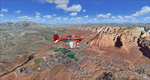
FS2004 Scenery - Telluride Regional Airport (IATA: TEX, ICAO: KTEX) is a public airport located 5 miles (8 km) west of Telluride, in San Miguel County, Colorado, USA. It is the highest commercial airport in North America, at an elevation of 9,078 feet (2767 m) above sea level. Located on a plateau, the airport's single runway literally dips slightly in the centre. This is version 3. Unlike versions 1 and 2, this scenery had the advantage of Google Earth's satellite image. Created using Instant Scenery by John B. Loney, Jr.
| Filename: |
ktex_v3.zip |
| License: |
Freeware, limited distribution |
| Added: |
25th March 2008, 15:55:10 |
| Downloads: |
2761 |
| Author: |
John B. Loney, Jr. |
| Size: |
17639kb |
|
|
File Description:
Telluride has not accurate right in the original default. I modify more improved details.
| Filename: |
ktex_384440.zip |
| License: |
Freeware |
| Added: |
27th June 2020, 17:59:03 |
| Downloads: |
163 |
| Author: |
Stuart John Gilbert II |
| Size: |
3981kb |
|
|
Images related to this file:
|
File Description:
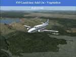
Landclass Improvements for the USA, specialy the western part of the USA: Colorado, Utah, Yellowstone, little Part of Idaho, Montana and from LA to Seattle. This is a complete Update, please delete the old scenery folders.Udate: Utah+Colorado (changing urban forest LC to Crops +Fields), California Sierra Nevada LC9 changed to LC130 & some small Cities around KMMH/KBIH. The LC Scenery's are for further devolpment, including *.inf & *raw files.
|
| Filename: |
fs9-lcv1-4.zip |
| License: |
Freeware |
| Added: |
1st March 2015, 15:39:07 |
| Downloads: |
372 |
| Author: |
Markus Balz |
| Size: |
2473kb |
|
  |


