|
AVSIM Library - Search Results
|
|
Login | Register | About logging in and out
|
|
Searching for: 'gottfried razek' in AVSIM File Library and below.
|

|
|
|
|
|
|
File Description:
This scenery covers another beautiful National Park: Arches National Park near Moab in Utah. It contains the park itself, Moab, the La Sal Moutains and the northern part of Canyonlands National Park, which will be covered in an upcoming package. The total area is 3.500 sq km and comes in 4.7m/pix quality. To explore the scenery depart from Canyonlands Field Airport (KCNY) and head south. YourDonation@Work: Dedicated to Hector, William and Jerald. Thanks!
| Filename: |
cny2009_lr.zip |
| License: |
Freeware, limited distribution |
| Added: |
5th January 2009, 19:31:11 |
| Downloads: |
3670 |
| Author: |
Gottfried Razek - www.blueskyscenery.com |
| Size: |
96951kb |
|
|
Images related to this file:
|
File Description:
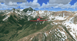
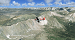
There sure is more than one reason to go to Aspen and this is sure another must-have of my Colorado sceneries. If you're coming IFR there's a couple of very demanding approach procedures. From a LOC/DME to several visual approaches there's everything your heart might desire. Due to the steep and high surrounding terrain these are quiet some hair raisers (see www.airnav.com/airport/KASE). If you're coming VFR then the traffic pattern altitude is 9.005 ft for light aircraft (vs. 9.505 for aircraft 12.500 lbs or more). Weather and wind permitting, RW15 is preferred for all landings (left pattern). RW33 has a right pattern and is preferred for all takeoffs. You even need a written permission to depart RW15. When departing VFR make a right turn to a heading of 360 degrees ASAP for noise abatement and hold this heading for at least 2 miles from the field. And don't forget to enjoy the impressive mountain scenery with two 14ers: Snowmass Mtn. and Castle Pk. to the southwest. This scenery brings you another 3.500 sq km of beautiful Colorado in 4.7m/pix quality. High resolution versions of this scenery for FS9 and FSX (much sharper, but larger and multiple downloads) are available at www.blueskyscenery.com/GNB_South2West2.html . The screenies are taken from the high-res versions, so expect this version to be slightly more blurry. YourDonation@Work: Dedicated to Mark, Markus and Yves.
|
| Filename: |
gnb_south2west2_2010_lr.zip |
| License: |
Freeware, limited distribution |
| Added: |
30th January 2010, 17:04:55 |
| Downloads: |
3506 |
| Author: |
Gottfried Razek - blueskyscenery.com |
| Size: |
94719kb |
|
|
|
Images related to this file:
|
File Description:
Blanding (KBDG), Utah, Photo-Scenery (FS9 & FSX)
This scenery covers the area around Blanding, Utah (KBDG), extending from just south of Monticello to Bluff (66V) and the northern part of the Comb Ridge. It extends my Canyonlands sceneries to the south and brings you another 3.500 sq km of wonderful southern Utah in 4.7m/pix quality. To explore the scenery depart from Blanding (KBDG). High resolution versions of this scenery for FS9 and FSX (much sharper, but larger and multiple downloads) are available at
www.blueskyscenery.com/CNY_South2.html. The screenies are taken from the high-res versions, so expect this version to be slightly more blurry. YourDonation@Work: Dedicated to Joseph, Rainer and Cesare.
|
| Filename: |
cny_south2_2010_lr.zip |
| License: |
Freeware, limited distribution |
| Added: |
4th January 2010, 19:09:22 |
| Downloads: |
1591 |
| Author: |
Gottfried Razek, blueskyscenery.com |
| Size: |
98095kb |
|
|
File Description:
The default airports in FS2004 have some conflicts with the beautifull photographic scenery of Gottfried Razek (Blue Sky Scenery), available on www.avsim.com. So here is the second series of the remaining AFCADs (see also the first serie AFCADS; blueskyscen1.zip) in the Los Angeles area to correct that.
| Filename: |
blueskyscen2.zip |
| License: |
Freeware |
| Added: |
16th January 2007, 02:30:47 |
| Downloads: |
1006 |
| Author: |
Joop Mak |
| Size: |
33kb |
|
|
File Description:
In the file : BlySkyScen1.zip was a wrong version of the AFCAD of KLGB from the High Resolution Scenery of Gottfried Razek.
Here is the correct one.
| Filename: |
blueskyscenupd.zip |
| License: |
Freeware |
| Added: |
17th January 2007, 19:15:29 |
| Downloads: |
856 |
| Author: |
Joop Mak |
| Size: |
8kb |
|
|
File Description:
The default airports in FS2004 has some conflicts with the beautifull fotografic scenery of Gottfried Razek , available on www.avsim.com .
So here are some new AFCADs of the mayor airports in Calfornia and Oahu in Hawaii , which are in the BlueSkyScenery too, to correct that.
| Filename: |
blueskyscen1.zip |
| License: |
Freeware |
| Added: |
12th January 2007, 19:53:35 |
| Downloads: |
1285 |
| Author: |
Joop Mak |
| Size: |
70kb |
|
|
Images related to this file:
|
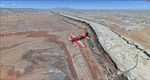
File Description:
Boulder is situated where the Rocky Mountains meet the Great Plains. Just west of the city are imposing slabs of sedimentary stone tilted up on the foothills, known as Flatirons. Located at the base of the foothills is Boulder's main campus of the University of Colarado which is clearly visible from the sky. Longmont is home of the Denver ARTCC (Air Route Traffic Control Center) which controls all flights in the upper airspace of most of Colorado and parts of adjoining states. To explore the scenery depart from Boulder (KBDU) and head northeast. Extends my Rocky Mountain Park scenery to the east and my Denver scenery to the north. Provides another 3.500 sq km in 4.7m/pix quality. High resolution versions for FS9 and FSX (much sharper, but larger and multiple downloads) are available at www.blueskyscenery.com/GNB_East.html . The screenies are taken from the high-res versions, so expect this version to be slightly more blurry. YourDonation@Work: Dedicated to Senges and Eric.
|
| Filename: |
gnb_east2009_lr.zip |
| License: |
Freeware, limited distribution |
| Added: |
28th December 2009, 20:14:09 |
| Downloads: |
2347 |
| Author: |
Gottfried Razek - blueskyscenery.com |
| Size: |
96520kb |
|
|
Images related to this file:
|
File Description:
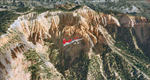
Bryce Canyon National Park (KBCE), Utah, Photo-Scenery (FS9 & FSX)
Despite its name, Bryce Canyon is not actually a canyon that was formed by a river, but rather a giant natural cliff shaped through erosion by wind, water, and ice. Bryce is distinctive due to its geological formations, delicate and colorful pinnacles called hoodoos that are up to 200ft high. The bizarre forms and red, orange and white colors of the rocks provide spectacular views. Unfortunately the hoodoos are too small for the elevation mesh in flight simulator. But you can enjoy the colors and shape of the cliffs. The cliffs in main region of the park, just south of the airport are partly covered
by snow. But on the southern and western part of the plateau you can enjoy them free of snow. Bryce Canyon is named after the Mormon pioneer Ebenezer Bryce who settled in this area in the 1850s. It was designated as a national park in 1928.
Bryce Canyon Airport (KBCE) just handles small aircraft on a daily basis. But is was actually built to handle larger aircraft in case of emergency. And so on Oct.6th 2000 an American Airlines MD-82 from Denver to Los Angeles made a successful emergency landing after reporting smoke in the cockpit and a loss of cabin pressure.
High resolution versions of this scenery for FS9 and FSX (much sharper, but larger and multiple downloads)are available at www.blueskyscenery.com/CNY_South2West4.html . The screenies are taken from the high-res versions, so expect this version to be slightly more blurry. Thanks to Joop Mak for providing a custom AFCADs that correct airport layouts so that they align with the photo-textures! They are available here: www.blueskyscenery.com/AFCADs.html . YourDonation@Work: Dedicated to Michael, Pat and Keith.
|
| Filename: |
cny_south2west4_2010_lr.zip |
| License: |
Freeware, limited distribution |
| Added: |
7th March 2010, 11:17:56 |
| Downloads: |
2163 |
| Author: |
Gottfried Razek, blueskyscenery.com |
| Size: |
98666kb |
|
|
Images related to this file:
|
File Description:
This region covers the area around Buena Vista and Central Colorado Reg. (KAEJ form. 7V1). It extends
my Leadville scenery to the south and brings you another 3.500 sq km of beautiful Colorado in 4.7m/pix quality. High resolution versions of this scenery for FS9 and FSX (much sharper, but larger and multiple downloads) are available at www.blueskyscenery.com/GNB_South3West.html . The screenies are taken from the high-res versions, so expect this version to be slightly more blurry. YourDonation@Work: Dedicated to Matias and Markus.
|
| Filename: |
gnb_south3west_2010.zip |
| License: |
Freeware, limited distribution |
| Added: |
7th February 2010, 11:31:14 |
| Downloads: |
1546 |
| Author: |
Gottfried Razek - blueskyscenery.com |
| Size: |
96141kb |
|
|
Images related to this file:
|
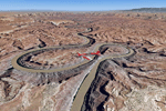
File Description:
This scenery covers the southern part of Canyonlands National Park (Needles District) in Utah. The colorful layers of sand- and limestone that you can see today built over hundreds of millions years by advancing and retreating oceans as well as rivers that deposited huge amounts of sediment. About 15 million years ago these layers began to rise due to a colliding movement of plates in the earth's crust, forming what is today called the Colorado Plateau. As the land rose higher, erosion accelerated, resulting in countless canyons, mesas and buttes. The uplifting land caused the rivers to carve in even faster, resulting in the deep canyons of the Colorado and Green Rivers. The needles and fins in the Needles District have yet another story: First uplifts and later slides created a system of perpendicular cracks. Then he resulting crosshatched pattern of "joints" widened by erosion until only thin fins and needles of rock remained. The scenery extends my Arches National Park scenery to the south and brings you another 3.500 sq km in 4.7m/pix quality. To explore the scenery depart from Monticello (U43) and head north. YourDonation@Work: Dedicated to Nels, David and Michael. Thanks!
|
| Filename: |
cny_south2009_lr.zip |
| License: |
Freeware, limited distribution |
| Added: |
30th December 2009, 21:44:56 |
| Downloads: |
1495 |
| Author: |
Gottfried Razek - blueskyscenery.com |
| Size: |
98054kb |
|
  |


