|
AVSIM Library - Search Results
|
|
Login | Register | About logging in and out
|
|
Searching for: 'gottfried razek' in AVSIM File Library and below.
|

|
|
|
|
|
|
Images related to this file:
|
File Description:
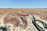
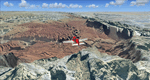
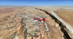
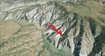
This is a re-upload of a package that was corrupted during the crash of the AVSIM library. The Maze is the wildest and least accessible district of Canyonlands National Park. It is a perplexing jumble of canyons that has been described as a '30 sq miles puzzle in sandstone'. The Maze covers the area west of the Green River and north of the Colorado River. Getting to most locations requires multiple hours of 4WD road driving. Hiking trails usually require multi day backpack trips.
Too strenous? Let's go flying! Checking out the area from an eagles perspective is certainly a stunning experience. The colors are awesome and the landforms are of breathtaking beauty. The scenery extends my Arches National Park scenery to the west and brings you another 3.500 sq km in 4.7m/pix quality. YourDonation@Work: Dedicated to Frans, Francois and James. Thanks!
|
| Filename: |
cny_west2009_lr.zip |
| License: |
Freeware, limited distribution |
| Added: |
31st December 2009, 11:01:39 |
| Downloads: |
2344 |
| Author: |
Gottfried Razek - blueskyscenery.com |
| Size: |
95112kb |
|
|
Images related to this file:
|
File Description:
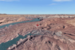
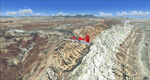
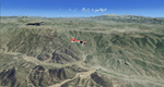
This is a re-upload of a package that was corrupted during the crash of the AVSIM library. This is the fourth package of the Arches/Canyonlands area. It covers the area southwest and including the confluence of the Colorado and Green Rivers. From there you can fly down Cataract Canyon which is famed for its premium whitewater rafting oportunities. Or explore the Maze (the area west of the Green and north of the Colorado River) with it's labyrinth of canyons and colorful sandstone formations. The scenery extends west to Hite (UT03) on Lake Powell. Brings the total Southern Utah coverage to 14.000 sq km in 4.7m/pix quality. YourDonation@Work: Dedicated to Patrick, Hideyuki and Art. Thanks!
|
| Filename: |
cny_southwest2009_lr.zip |
| License: |
Freeware, limited distribution |
| Added: |
31st December 2009, 22:33:46 |
| Downloads: |
2051 |
| Author: |
Gottfried Razek - blueskyscenery.com |
| Size: |
97965kb |
|
|
|
Images related to this file:
|
File Description:
Capitol Reef National Park/North - Hanksville (KHVE), Utah, Photo-Scenery (for FS9 & FSX)
This scenery covers the northern part of Capitol Reef National Park, Hanksville (KHVE), the Goblin Valley and extends north to I70 and the San Rafael Swell. It extends my Canyonlands sceneries to the west and brings you another 3.500 sq km in 4.7m/pix quality. To explore the scenery depart from Hanksville (KHVE) and head northwest. High resolution versions of this scenery for FS9 and FSX (much sharper, but larger and multiple downloads) are available at www.blueskyscenery.com/CNY_West2.html . The screenies are taken from the high-res versions, so expect this version to be slightly more blurry. YourDonation@Work: Dedicated to Andy and Robert.
|
| Filename: |
cny_west2_2010_lr.zip |
| License: |
Freeware, limited distribution |
| Added: |
13th January 2010, 19:32:33 |
| Downloads: |
1666 |
| Author: |
Gottfried Razek, blueskyscenery.com |
| Size: |
97043kb |
|
|
Images related to this file:
|
File Description:
Capitol Reef National Park/South - Waterpocket Fold, Utah, Photo-Scenery (for FS9 & FSX)
This scenery covers the area from the southern part of Capitol Reef National Park down along the Waterpocket Fold and the Henry Mountains. It extends my Canyonlands sceneries to the west and brings you another 3.500 sq km in 4.7m/pix quality. To explore the scenery depart from Hanksville (KHVE) and head northwest. High resolution versions of this scenery for FS9 and FSX (much sharper, but larger and multiple downloads)
are available at www.blueskyscenery.com/CNY_SouthWest2.html . The screenies are taken from the high-res versions, so expect this version to be slightly more blurry. YourDonation@Work: Eric and Andy.
|
| Filename: |
cny_southwest2_2010_lr.zip |
| License: |
Freeware, limited distribution |
| Added: |
13th January 2010, 20:46:53 |
| Downloads: |
1698 |
| Author: |
Gottfried Razek - blueskyscenery.com |
| Size: |
98218kb |
|
|
Images related to this file:
|
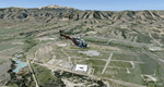
File Description:
This region covers the area between Denver and Colorado Springs. It extends my Denver scenery to the south.
Just north of Colorado Springs you can see the widespread United States Air Force Academy which, with it's
many buildings, covers a huge area of 18.000 acres. The Academy Airfield (KAFF) which lays in the northeastern
corner of the area is used for training cadets in airmanship courses, including parachute training,
soaring and powered flight.
High resolution versions of this scenery for FS9 and FSX (much sharper, but larger and multiple downloads)
are available at www.blueskyscenery.com/GNB_South2East.html . The screenies are taken from the high-res versions,
so expect this version to be slightly more blurry. YourDonation@Work: Dedicated to Robin and Raymond.
|
| Filename: |
gnb_south2east_2010_lr.zip |
| License: |
Freeware, limited distribution |
| Added: |
3rd February 2010, 02:09:59 |
| Downloads: |
2150 |
| Author: |
Gottfried Razek - blueskyscenery.com |
| Size: |
99241kb |
|
|
Images related to this file:
|
File Description:
Colorado Springs South (KCOS), Colorado, Photo-Scenery (FS9 & FSX)
This region covers the area of Colorado Springs. Just west of the city you can fly around Pikes Peak. At 14.115ft it is the easternmost of Colorado's 54 fourteeners. Northwest of the city lies the Garden Of Gods with its many vertical rock formations. They are made of sedimentary beds red and white sandstones, conclomerates and limestone that were deposited horizontally but have been tilted vertically and faulted by the immense mountain building forces caused by the uplift of the Pikes Peak massiv. Deep within Chayenne Mountain is the North American Aerospace Defense Command's (NORAD) main technical facility which collects and evaluates data from a worldwide system of satellites, radars and other sensors.
High resolution versions of this scenery for FS9 and FSX (much sharper, but larger and multiple downloads) are available at www.blueskyscenery.com/GNB_South3East.html . The screenies are taken from the high-res versions, so expect this version to be slightly more blurry. YourDonation@Work: Dedicated to Veit and Hector.
|
| Filename: |
gnb_south3east_2010_lr.zip |
| License: |
Freeware, limited distribution |
| Added: |
5th February 2010, 16:30:42 |
| Downloads: |
1938 |
| Author: |
Gottfried Razek, blueskyscenery.com |
| Size: |
97923kb |
|
|
Images related to this file:
|
File Description:
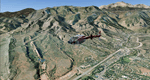
Comb Ridge, Rock Point (49AZ), Utah/Arizona, Photo-Scenery (FS9 & FSX)
This scenery extends my Monument Valley scenery to the east. It covers the area between the San Juan River in the north down to Rock Point, AZ (49AZ). Most of the scenery lies on the Navajo Nation Reservation. It completes the southeastern corner of Utah and paves our way into Colorado.
High resolution versions of this scenery for FS9 and FSX (much sharper, but larger and multiple downloads) are available at www.blueskyscenery.com/CNY_South3West6.html . The screenies are taken from the high-res versions, so expect this version to be slightly more blurry. Thanks to Joop Mak for providing custom AFCADs that correct airport layouts so that they align with the photo-textures! They are available at www.blueskyscenery.com/AFCADs.html . YourDonation@Work: Dedicated to Olivier, Kevin and Ruben.
|
| Filename: |
cny_south3_2010_lr.zip |
| License: |
Freeware, limited distribution |
| Added: |
9th April 2010, 21:57:41 |
| Downloads: |
1326 |
| Author: |
Gottfried Razek, blueskyscenery.com |
| Size: |
93174kb |
|
|
Images related to this file:
|
File Description:
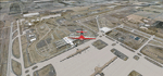
Denver (KDEN), Colorado, Photo-Scenery for FS9 & FSX.
This package covers Denver, the capital of Colorado which is also nicknamed Mile-High City because its elevation is one mile (5.280 ft). The sixth RW (16R/34L) of Denver Int'l. Airport (KDEN) is the longest commercial RW in the US with a length of 16.000ft. This allows fully loaded B747's to take off in Denvers mile-high altitude during hot summer days, when density altitudes can approach 9.000(!) ft.
KDEN is a major hub for United Airlines and the headquarters for Frontier Airlines. The airports distinctive white tent-like fabric roof is designed to be reminiscent of the snow-covered peaks of the Rocky Mountains which you can see on approach or departure.
Other important airports covered by this region are Centennial Airport (KAPA), Buckley AFB (KBKF) and Rocky Mountain Metropolitan Airport (KBJC). Extends my Mt.Evans/Georgetown package to the east and provides another 3.500 sq km in 4.7m/pix quality.
High resolution versions for FS9 and FSX (much sharper, but larger and multiple downloads) are available at www.blueskyscenery.com/GNB_SouthEast.html
. The screenies are taken from the high-res versions, so expect this version to be slightly more blurry. YourDonation@Work: Dedicated to Mark and Charles. Thanks!
|
| Filename: |
gnb_southeast2009_lr.zip |
| License: |
Freeware, limited distribution |
| Added: |
31st October 2009, 11:24:39 |
| Downloads: |
7100 |
| Author: |
Gottfried Razek, blueskyscenery.com |
| Size: |
97493kb |
|
|
Images related to this file:
|
File Description:
To explore this region depart from Eagle County Regional Airport (KEGE) which is a popular regional airport used in winter to transport skiers to nearby Vail. Northwest of the airport you can see the pit gypsum mine of American Gypsum which produces a variety of wallboard products. When you fly to the west and along the Eagle River, you soon pass its confluence with the Colorado River. Further west you can fly along Glennwood Canyon and finally reach Glennwood Springs where the Colorado meets the Roaring Fork River. Here you can turn south and fly direct Glenwood Springs Airport (KGWS) which lies south of the city. This scenery brings you another 3.500 sq km of beautiful Colorado in 4.7m/pix quality.
High resolution versions of this scenery for FS9 and FSX (much sharper, but larger and multiple downloads) are available at www.blueskyscenery.com/GNB_SouthWest2.html . The screenies are taken from the high-res versions, so expect this version to be slightly more blurry. YourDonation@Work: Dedicated to Alain and James.
|
| Filename: |
gnb_southwest2_2010_lr.zip |
| License: |
Freeware, limited distribution |
| Added: |
30th January 2010, 17:01:49 |
| Downloads: |
2651 |
| Author: |
Gottfried Razek - blueskyscenery.com |
| Size: |
96052kb |
|
|
Images related to this file:
|
File Description:
Fremont County, Colorado, Photo-Scenery (FS9 & FSX)
Covers the gap between my Buena Vista and Colorado Springs South sceneries and provides you with continuous coverage for longer cross country flights. High resolution versions of this scenery for FS9 and FSX (much sharper, but larger and multiple downloads) are available at www.blueskyscenery.com/GNB_South3.html . The screenies are taken from the high-res versions, so expect this version to be slightly more blurry. YourDonation@Work: Dedicated to Senges and Dennis.
|
| Filename: |
gnb_south3_2010_lr.zip |
| License: |
Freeware, limited distribution |
| Added: |
13th February 2010, 14:33:42 |
| Downloads: |
1302 |
| Author: |
Gottfried Razek, blueskyscenery.com |
| Size: |
94323kb |
|
  |


