|
AVSIM Library - Search Results
|
|
Login | Register | About logging in and out
|
|
Searching for: 'gottfried razek' in AVSIM File Library and below.
|

|
|
|
|
|
|
Images related to this file:
|
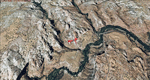
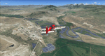
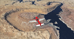
File Description:
This scenery contains the eastern part of the Grand Staircase Escalante National Monument. It extends from the town of Escalante down south where it connects with the Page/Lake Powell scenery. Contains the upper part of wonderful Escalante Canyon. To explore the scenery depart from Escalante Airport (1L7). Thanks to Joop Mak for providing a custom AFCAD that corrects the airport layout so that it matches with the photo-textures! High resolution versions of this scenery for FS9 and FSX (much sharper, but larger and multiple downloads) are available at www.blueskyscenery.com/CNY_South2West3.html . The screenies are taken from the high-res versions, so expect this version to be slightly more blurry. YourDonation@Work: Dedicated to Jay, Donald and Franz
|
| Filename: |
cny_south2west3_2010_lr.zip |
| License: |
Freeware, limited distribution |
| Added: |
4th March 2010, 22:44:30 |
| Downloads: |
1461 |
| Author: |
Gottfried Razek - blueskyscenery.com |
| Size: |
98510kb |
|
|
Images related to this file:
|
File Description:
Gunnison (KGUC), Colorado, Photo-Scenery (FS9 & FSX)
Extends my Aspen scenery to the south from Crested Butte to Gunnison (KGUC) and beyond. Contains the West Elk Wilderness Area and the Curecanti Nat'l. Rec. Area around Morrow Point Reservoir. This scenery brings you another 3.500 sq km of beautiful Colorado in 4.7m/pix quality.
High resolution versions of this scenery for FS9 and FSX (much sharper, but larger and multiple downloads) are available at www.blueskyscenery.com/GNB_South3West2.html . The screenies are taken from the high-res versions, so expect this version to be slightly more blurry. YourDonation@Work: Dedicated to Alain, Jacques and Lefevre.
|
| Filename: |
gnb_south3west2_2010.zip |
| License: |
Freeware, limited distribution |
| Added: |
6th February 2010, 11:08:59 |
| Downloads: |
1702 |
| Author: |
Gottfried Razek, blueskyscenery.com |
| Size: |
93008kb |
|
|
|
File Description:
FS2004 100 situations created for helicopter flights.
Airmed rescues, mountains and sea search and rescue, executive freighters, ecologic missions, police services and
more.
for use with Lago FS Enhancer program and Gottfried Razek Los Angeles and Catalina island sceneries.
Created by Andr� Bernard (Centro Aeron�utico virtual). Bahia - Brazil.
| Filename: |
heli_missions.zip |
| License: |
Freeware |
| Added: |
17th July 2008, 19:50:59 |
| Downloads: |
437 |
| Author: |
Andr� Bernard M. Drumond |
| Size: |
3439kb |
|
|
File Description:
The Heli Missions project is created for use with Lago FS Enhancer program and Gottfried Razek Los Angeles-Catalina island sceneries.
100 missions and flights around LA area.
Heli Med Transport, police operations, ecological missions, executive freighters, search and rescue in sea and
moutains missions.
By Andr� Drumond (Centro Aeron�utico virtual) Brazil.
| Filename: |
heli_missions_243107.zip |
| License: |
Freeware |
| Added: |
17th July 2008, 20:01:13 |
| Downloads: |
434 |
| Author: |
Andr� Drumond |
| Size: |
3439kb |
|
|
Images related to this file:
|
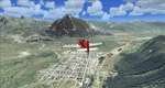
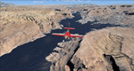
File Description:
This scenery covers the southwestern part of Grand Staircase-Escalante National Monument. From the air
you can see all the "stairs" from the Pink Cliffs of Bryce Canyon in the north down to the Grey Cliffs,
the White Cliffs and the Vermillion Cliffs just north of Kanab and then the Chocolate Cliffs further south.
Nothwest of Kanab you can fly above beautiful Coral Pink Sand Dunes State Park which features coral-hued
sand dunes located beside red sandstone cliffs. These dunes consist of sand that formed thru erosion of
pink colored Navajo Sandstone surrounding the park and was deposited by wind. To explore the scenery depart
from Kanab Airport (KKNB).
High resolution versions of this scenery for FS9 and FSX (much sharper, but larger and multiple downloads)
are available at www.blueskyscenery.com/CNY_South3West4.html . The screenies are taken from the high-res versions,
so expect this version to be slightly more blurry. Thanks to Joop Mak for providing custom AFCADs that
correct airport layouts so that they align with the photo-textures! They are available at
www.blueskyscenery.com/AFCADs.html . YourDonation@Work: Dedicated to Jesper, Fabrizio and Glen.
|
| Filename: |
cny_south3west4_2010_lr.zip |
| License: |
Freeware, limited distribution |
| Added: |
10th March 2010, 22:24:53 |
| Downloads: |
1485 |
| Author: |
Gottfried Razek - blueskyscenery.com |
| Size: |
97647kb |
|
|
Images related to this file:
|
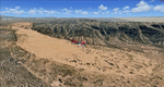
File Description:
Kremmling, Mc Elroy (20V), Colorado, Photo-Scenery (FS9 & FSX)
Ever wanted to know how the scenery looks like around Kremmling VOR? Now you got the chance! This region covers the area around Kremmling and the northern part of the Gore Range. At Kremmling the Colorado River meets both the Blue River and the Muddy Creek. West of Kremmling you can see Gore Canyon. This rugged and steep canyon is almost 1000ft deep and was carved by the Colorado River on its way thru the Gore Range.
To explore the scenery depart from Mc Elroy Airfield (20V) in Kremmling and head north. High resolution versions of this scenery for FS9 and FSX (much sharper, but larger and multiple downloads) are available at www.blueskyscenery.com/GNB_West.html . The screenies are taken from the high-res versions, so expect this version to be slightly more blurry. Thanks to Joop Mak for providing custom AFCADs that correct airport layouts so that they align with the photo-textures! They are available at www.blueskyscenery.com/AFCADs.html . YourDonation@Work: Dedicated to Michael.
|
| Filename: |
gnb_west_2010.zip |
| License: |
Freeware, limited distribution |
| Added: |
21st April 2010, 17:39:09 |
| Downloads: |
1118 |
| Author: |
Gottfried Razek, blueskyscenery.com |
| Size: |
93384kb |
|
|
Images related to this file:

|
File Description:
KSEZ Sedona Airfield for FSX.
Designed to fit the footprint of the free Blue Sky Scenery Project created by Gottfried Razek.
Custom made models of the hangar area, restaurant, arrivals/departure block, fuel store and nearby hotel buildings together with "AGN" tree and shrub pack covering the area of Airport Mesa.
|
| Filename: |
ksez_sedona.zip |
| License: |
Freeware, limited distribution |
| Added: |
10th January 2013, 21:53:51 |
| Downloads: |
1732 |
| Author: |
Anthony R Meredith |
| Size: |
1604kb |
|
|
File Description:
This is the missing AFCAD for the magnificent fotografic addon scenery of SanFransico from Gottfried Razek for the airport KSFO.
You need sfo2006_hr.zip , also available om www.avsim.com
| Filename: |
afc_ksfo.zip |
| License: |
Freeware |
| Added: |
8th December 2006, 14:03:44 |
| Downloads: |
1019 |
| Author: |
Joop Mak |
| Size: |
18kb |
|
|
Images related to this file:
|
File Description:
This scenery covers the area from the southern end of the Waterpocket Fold down to the Bullfrog Basin and the eastern end of the Kiaparowits Plateau. It extends my Canyonlands sceneries to the southwest and brings you another 3.500 sq km in 4.7m/pix quality. To explore the scenery depart from Bullfrog Basin Airport (U07) and west. High resolution versions of this scenery for FS9 and FSX (much sharper, but larger and multiple downloads)
are available at www.blueskyscenery.com/CNY_South2West2.html . The screenies are taken from the high-res versions, so expect this version to be slightly more blurry. YourDonation@Work: Dedicated to Jean-Marc, Jim and Cay.
|
| Filename: |
cny_south2west2_2010_lr.zip |
| License: |
Freeware, limited distribution |
| Added: |
18th January 2010, 19:27:52 |
| Downloads: |
1568 |
| Author: |
Gottfried Razek - blueskyscenery.com |
| Size: |
95062kb |
|
|
Images related to this file:
|
File Description:
Lake Powell East / Natural Bridges National Monument, Utah, Photo-Scenery (FS9 & FSX)
This scenery covers the eastern part of Lake Powell from just south of Hite (UT03) and goes down south along White Canyon, Natural Bridges National Monument and the Grand Gulch Primitive Area all the way to the San Juan River. It extends my Canyonlands sceneries to the south and brings you another 3.500 sq km of wonderful southern Utah in 4.7m/pix quality. To explore the scenery depart from Cal Black Memorial Apt. (U96) and head east. High resolution versions of this scenery for FS9 and FSX (much sharper, but larger and multiple downloads) are available at www.blueskyscenery.com/CNY_South2West.html. The screenies are taken from the high-res versions, so expect this version to be slightly more blurry. YourDonation@Work: Dedicated to Guy, Ruben and EDB.
|
| Filename: |
cny_south2west_2010_lr.zip |
| License: |
Freeware, limited distribution |
| Added: |
4th January 2010, 19:19:43 |
| Downloads: |
1839 |
| Author: |
Gottfried Razek, blueskyscenery.com |
| Size: |
97544kb |
|
  |


