
Where Flight Simulation Enthusiasts Gather from Around the World!
AVSIM Library - Search Results

| Category: Flight Simulator 2004 - Scenery | |
| City of Mesa, Arizona USA |

|
File Description:
Here is small city addon scenery for FS9. The City of Mesa, Arizona, located in southeast of Phoenix, near Sky Harbour airport. Includes four famous buildings from Mesa city area.
| Filename: | City_of_Mesa_Arizona_USA.zip |
| License: | Freeware |
| Added: | 13th October 2005, 22:56:46 |
| Downloads: | 2,831 |
| Author: | Toni Hiltunen |
| Size: | 302.17 KB |
| Category: Flight Simulator 2004 - Scenery | |
| "Himalayan Peaks" LOD10 Mesh, Volume 5 - Garhwal |
|
File Description:
Highly detailed terrain mesh of the Garhwal area, N30°-32° E78°-81°. The files in this package are based on Shuttle Radar (SRTM) Version 2 data but with many of the void areas, especially the most significant sections, filled with elevation data generated from topographic maps by Jonathan de Ferranti. While Jonathan's work is unrelated to flight simulation he kindly gave me permission to compile his data for use in FS. The result is a wonderful improvement in detail and accuracy over any existing mesh file, freeware or commercial, based on SRTM or DTED data alone. Due to the large area of the Himalayas I've compiled the source data as two separate series: the "Himalayan Peaks" series covers prominent mountains and ranges in higher detail and locally overrides any existing LOD9 terrain mesh. In addition, a LOD9 "base mesh" series covering the entire Himalayas will be available for those who do not yet have an add-on terrain mesh of these beautiful mountains.
| Filename: | Himalayan_Peaks_LOD10_Mesh_Volume_5__Garhwal.zip |
| License: | Freeware, limited distribution |
| Added: | 18th February 2006, 23:16:47 |
| Downloads: | 10,134 |
| Author: | Holger Sandmann and Jonathan de Ferranti |
| Size: | 27.72 MB |
| Category: Flight Simulator 2004 - Scenery | |
| "Himalayan Peaks" LOD10 Mesh, Volume 6 - Jammu and Kashmir |
|
Images related to this file:
File Description:
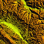
Highly detailed terrain mesh of the Jammu and Kashmir areas, N31-36 E76-78. The files in this package are based on Shuttle Radar (SRTM) Version 2 data but with many of the void areas, especially the most significant sections, filled with elevation data generated from topographic maps by Jonathan de Ferranti. While Jonathan's work is unrelated to flight simulation he kindly gave me permission to compile his data for use in FS. The result is a wonderful improvement in detail and accuracy over any existing mesh file, freeware or commercial, based on SRTM or DTED data alone.
Due to the large area of the Himalayas I've compiled the source data as two separate series: the "Himalayan Peaks" series covers prominent mountains and ranges in higher detail and locally overrides any existing LOD9 terrain mesh. In addition, a LOD9 "base mesh" series covering the entire Himalayas will be available for those who do not yet have an add-on terrain mesh of these beautiful mountains.
| Filename: | Himalayan_Peaks_LOD10_Mesh_Volume_6__Jammu_and_Kas.zip |
| License: | Freeware, limited distribution |
| Added: | 29th May 2010, 08:55:43 |
| Downloads: | 9,666 |
| Author: | Holger Sandmann, Jonathan de Ferranti |
| Size: | 52.19 MB |
| Category: Flight Simulator 2004 - Scenery | |
| Mesh Install Instructions for Oregon and Washington Sceneries |
|
File Description:
I forgot to upload this with the SRTM Mesh, Sorry for the mistake folks.
| Filename: | Mesh_Install_Instructions_for_Oregon_and_Washingto.zip |
| License: | Freeware |
| Added: | 5th April 2004, 03:58:59 |
| Downloads: | 4,612 |
| Author: | John Wardle |
| Size: | 116.72 KB |
| Category: Flight Simulator 2004 - Scenery | |
| "Himalayan Peaks" LOD10 Mesh, Volume 7 - K2 and Karakoram |
|
Images related to this file:
File Description:

Highly detailed terrain mesh of the Karakoram area, N35-37 E73-77. The files in this package are based on Shuttle Radar (SRTM) Version 2 data but with many of the void areas, especially the most significant sections, filled with elevation data generated from topographic maps by Jonathan de Ferranti. While Jonathan's work is unrelated to flight simulation he kindly gave me permission to compile his data for use in FS. The result is a wonderful improvement in detail and accuracy over any existing mesh file, freeware or commercial, based on SRTM or DTED data alone.
Due to the large area of the Himalayas I've compiled the source data as two separate series: the "Himalayan Peaks" series covers prominent mountains and ranges in higher detail and locally overrides any existing LOD9 terrain mesh. In addition, a LOD9 "base mesh" series covering the entire Himalayas will be available for those who do not yet have an add-on terrain mesh of these beautiful mountains.
| Filename: | Himalayan_Peaks_LOD10_Mesh_Volume_7__K2_and_Karako.zip |
| License: | Freeware, limited distribution |
| Added: | 30th May 2010, 09:56:27 |
| Downloads: | 9,480 |
| Author: | Holger Sandmann, Jonathan de Ferranti |
| Size: | 38.58 MB |
| Category: Flight Simulator 2004 - Scenery | |
| "Himalayan Peaks" LOD10 Mesh, Volume 8 - Tirich Mir and Pamir |
|
Images related to this file:
File Description:
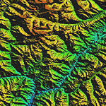
Highly detailed terrain mesh of the Tirich Mir and Pamir areas, N36-39 E71-74. The files in this package are based on Shuttle Radar (SRTM) Version 2 data but with many of the void areas, especially the most significant sections, filled with elevation data generated from topographic maps by Jonathan de Ferranti. While Jonathan's work is unrelated to flight simulation he kindly gave me permission to compile his data for use in FS. The result is a wonderful improvement in detail and accuracy over any existing mesh file, freeware or commercial, based on SRTM or DTED data alone.
Due to the large area of the Himalayas I've compiled the source data as two separate series: the "Himalayan Peaks" series covers prominent mountains and ranges in higher detail and locally overrides any existing LOD9 terrain mesh. In addition, a LOD9 "base mesh" series covering the entire Himalayas will be available for those who do not yet have an add-on terrain mesh of these beautiful mountains.
| Filename: | Himalayan_Peaks_LOD10_Mesh_Volume_8__Tirich_Mir_an.zip |
| License: | Freeware, limited distribution |
| Added: | 29th May 2010, 08:52:47 |
| Downloads: | 9,107 |
| Author: | Holger Sandmann, Jonathan de Ferranti |
| Size: | 47.94 MB |
| Category: Flight Simulator 2004 - Scenery | |
| Mactan-Cebu International Airport 2018 |
|
Images related to this file:
File Description:
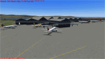
CEB / RPVM Cebu, Philippines. An update of Mactan-Cebu Airport, featuring the new 'Fiesta Terminal 2'!
| Filename: | MactanCebu_International_Airport_2018.zip |
| License: | Freeware |
| Added: | 2nd August 2018, 15:16:39 |
| Downloads: | 756 |
| Author: | Bobby Santos |
| Size: | 335.72 KB |
| Category: Flight Simulator 2004 - Scenery | |
| Mbeya Airport (HTMB) |
|
Images related to this file:
File Description:
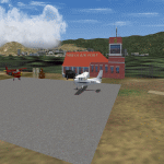
This is Mbeya Airport (HTMB) located in Southwest Tanzania. Now rarely used, after the opening the much bigger Songwe Airport. Built using Sketchup and built on top of default airport.
| Filename: | Mbeya_Airport_HTMB.zip |
| License: | Freeware |
| Added: | 4th January 2018, 17:30:53 |
| Downloads: | 191 |
| Author: | Emmanuel Mwandosya |
| Size: | 2.38 MB |
| Category: Flight Simulator 2004 - Scenery | |
| SAWE Tierra del Fuego |
|
File Description:
RIO GRANDE RASU GRA SAWE INTERNATIONAL CONTROLLED PUBLIC. THIS SCCENARY IS ACORDED TO THE NEW TERMINAL`S REAL CARASTERISTICS, BOTH GEOGRAPHICAL AND CONTRYSIDE. Argentina, Provincia Tierra del Fuego.
RWY: 07/25 2000x40 ASPHALT PCN:54/R/C/W/T
| Filename: | SAWE_Tierra_del_Fuego.zip |
| License: | Freeware |
| Added: | 24th January 2009, 01:58:01 |
| Downloads: | 1,214 |
| Author: | Roberto Julio Gómez |
| Size: | 21.75 MB |
| Category: Flight Simulator 2004 - Scenery | |
| Paphos International Airport LCPH |
|
Images related to this file:
File Description:

Paphos International Airport LCPH for FS2004. This is a complete redevelopment of Paphos International Airport and includes new passenger terminal building, old terminal buildings, freight area, GA flying club/fuel farm, military base and barracks new control tower plus other scenery in the vicinity of the airport. Also features full photoreal Gmax ground polygons, realistic textured night lighting and other visual enhancements. Enjoy beautiful Cyprus!
| Filename: | Paphos_International_Airport_LCPH.zip |
| License: | Freeware, limited distribution |
| Added: | 28th November 2010, 10:40:10 |
| Downloads: | 12,248 |
| Author: | Max Kraus |
| Size: | 25.55 MB |


© 2001-2026 AVSIM Online
All Rights Reserved
Privacy Policy |