
Where Flight Simulation Enthusiasts Gather from Around the World!
AVSIM Library - Search Results

| Category: Flight Simulator 2004 - Scenery | |
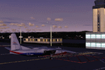
| City of Bartlesville, Oklahoma |

|
File Description:
Hi, here is one of my favorite city sceneries I made for FS2004. The city of Bartlesville is a city in Oklahoma state, near Arkansas State. This add-on adds few buildings to downtown area.
| Filename: | City_of_Bartlesville_Oklahoma.zip |
| License: | Freeware |
| Added: | 17th August 2005, 18:58:01 |
| Downloads: | 1,513 |
| Author: | Toni Hiltunen |
| Size: | 259.3 KB |
| Category: Flight Simulator 2004 - Scenery | |
| Anahim Lake CAJ4 in British Columbia, Canada |
|
Images related to this file:
File Description:
Anahim Lake is around 55 miles east of Bella Coola by air, and clear of the deep and rugged valley that connects the two with a road that is over 75 miles long. The two are also linked by a daily Pacific Coastal flight. A further 150 miles east is Williams Lake (200 miles by road). The town of Anahim Lake is small, but renowned for numerous surrounding fishing lodges on the lakes and the enjoyment of "nature" in what is known as the Chilcotin Wilderness. The Anahim Lake airport is an odd one. It appears to have fallen into disuse over a period of years, but is now in the process of being upgraded, with some new hangars (though oddly situated, and with only dirt track taxiway access) and a recently completed terminal building. There is also a plan to upgrade the runway (lights etc, there are currently no runway or taxiway lights) and in general to greatly improve the facilities on offer. The only current airline to fly there is Pacific Coastal. The runway is just under 4,000 feet of asphalt aligned 13-31 and 75 feet wide. There used to be another runway which is still visible but is now unusable, gravel that has not been maintained for several years. The notes for Anahim Lake airfield in the Nav Canada manual warn of "Extensive float plane activity at Nimpo Lake to the south" and of "possible large animals within the airport perimeter". Nimpo Lake activity will follow in further posts.
| Filename: | Anahim_Lake_CAJ4_in_British_Columbia_Canada.zip |
| License: | Freeware, limited distribution |
| Added: | 29th November 2018, 19:21:59 |
| Downloads: | 152 |
| Author: | Roger Wensley |
| Size: | 5.72 MB |
| Category: Flight Simulator 2004 - Scenery | |
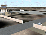
| VDSV - Sihanoukville International Airport - Sihanoukville, Cambodia |
|
Images related to this file:
File Description:
Sihanoukville VDSV airport Cambodia. Update to the standard scenery to make AI-Traffic work.
| Filename: | VDSV__Sihanoukville_International_Airport__Sihanou.zip |
| License: | Freeware |
| Added: | 8th July 2016, 14:16:48 |
| Downloads: | 224 |
| Author: | Thomas Gierse |
| Size: | 1009.47 KB |
| Category: Flight Simulator 2004 - Scenery | |
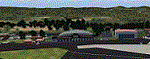
| Real Terrain© Colorado Pack 1 |
|
File Description:
In Real Terrain Colorado you will see the mountains just west of Denver in very high detail. You can actually take off from Denver international and struggle to stay above the terrain as you fly into the mountains, that is if you are using a small aircraft like the Cessna 172SP Skyhawk. Also in Real Terrain Colorado, It Creates Very detailed valleys. It is very relaxing flying through the valleys during a nice sunny afternoon. Real Terrain Colorado is Split up into two Packs. You do not need to download both packs to enjoy this Scenery, buy it is Highly Recommended.
| Filename: | Real_Terrain_Colorado_Pack_1.zip |
| License: | Freeware |
| Added: | 23rd September 2003, 02:00:17 |
| Downloads: | 7,862 |
| Author: | David P Smith |
| Size: | 38.01 MB |
| Category: Flight Simulator 2004 - Scenery | |
| LKKV - Karlovy Vary Version 1.1 |
|
Images related to this file:
File Description:

Karlovy Vary (former Karlsbad) is a small regional airport in the Czech Republik a 100 miles northwest of the capital Prag. It has only one cennection to Moskau Sheremetjewo, but will start a additional service to Düsseldorf in Germany this summer 2018. This is (in parts) a rework of the great scenery Karlova Vary for FSX made by Milan Puta, Vojtech Cerny and Pavel Brodsky. As special service for FSX users, a FSX AFCAD (as alternative) is added to this package. This new version replaces the former version 1.0 with missing texture files, apron fences and the missing firestation building.
| Filename: | LKKV__Karlovy_Vary_Version_11.zip |
| License: | Freeware |
| Added: | 17th December 2017, 20:27:26 |
| Downloads: | 511 |
| Author: | David Kolas |
| Size: | 4.17 MB |
| Category: Flight Simulator 2004 - Scenery | |
| LKKV - Karlovy Vary Update2019 |
|
Images related to this file:
File Description:
In autumn 2018 significant changes have taken place at the airport of Karlovy Vary (repair work at the turnaround Rwy 11, apron redesign...). Further more, some villages and cities in the area of Karlovy Vary Airport have added to the scenery, to make the approach more realistic. So here is the update.
| Filename: | LKKV__Karlovy_Vary_Update2019.zip |
| License: | Freeware |
| Added: | 22nd April 2019, 16:40:29 |
| Downloads: | 202 |
| Author: | David Kolas |
| Size: | 714.18 KB |
| Category: Flight Simulator 2004 - Scenery | |
| Fort Good Hope CZGH - Northwest Territories, Canada |
|
Images related to this file:
File Description:
This is the second in a series of airfields that follow that early access route to the Canadian northern shore, the Mackenzie River. At the far northern end of the river there are Tuktoyaktuk, Inuvik, and Fort McPherson, all posted. Fort Good Hope is at 268 feet ASL and on the east bank of the Mackenzie, 180 miles southeast of Fort McPherson and 100 miles west of Great Bear Lake. The town has a population of around 560, and the main sources of income are from the traditional trapping and hunting. The airport is a mile south of the town, and has almost 4,000 feet of gravel runway. There are scheduled flights to the town by North Wright; I also have two AI GA flights and a Buffalo Airways delivery trip that hops north and south from field to field.
| Filename: | Fort_Good_Hope_CZGH__Northwest_Territories_Canada.zip |
| License: | Freeware, limited distribution |
| Added: | 4th July 2014, 21:03:03 |
| Downloads: | 276 |
| Author: | Roger Wensley |
| Size: | 3.08 MB |
| Category: Flight Simulator 2004 - Scenery | |
| Fort Resolution CYFR in the Northwest Territories, Canada |
|
Images related to this file:
File Description:
Fort Resolution is on the south side of Great Slave Lake, 75 miles east of Hay River and just west of where the Slave River flows into the lake from Fort Smith. Fort Resolution, the oldest community in the Territories and once a vital link in the fur trade business, is a small town with a population of around 500. It was not included in the original FS9 or Ultimate Terrain so I have added it here.
The airfield is next to the town on the lakeshore. The runway is 4,000 feet of gravel with a displaced threshold at the southern (town) end; it is lit and there is PAPI. There are no scheduled flights to Fort Resolution, just occasional charters; the AI includes a stock FS9 Cessna and a Wasaya Airways PC12.
| Filename: | Fort_Resolution_CYFR_in_the_Northwest_Territories_.zip |
| License: | Freeware, limited distribution |
| Added: | 4th October 2013, 22:11:26 |
| Downloads: | 294 |
| Author: | Roger Wensley |
| Size: | 2.31 MB |
| Category: Flight Simulator 2004 - Scenery | |
| Dhulia Airport, India |
|
Images related to this file:
File Description:
its always interesting and enjoyable to taxi an aircraft thru tight areas,and especially when a taxiway is
surrounded by trees like Eucalyptus,capable of attaining a height that can range anywhere between 6fts to 300fts! after a short evening
flight from Mumbai you've just landed at small airport at Dhulia(India) and vacated the runway, AND you've just spotted a
hanger, good! that's were you want to be, but hey! it's already occupied. now what?.Well..good news! there is another hanger,
but were? can't even see were taxiway is leading to because of dense trees. Can you find the Hanger? surely you don't
want to leave your cessna under open sky for whole night long or do you?
| Filename: | Dhulia_Airport_India.zip |
| License: | Freeware, limited distribution |
| Added: | 10th May 2011, 03:56:06 |
| Downloads: | 526 |
| Author: | Ashish Singh |
| Size: | 17.93 MB |
| Category: Flight Simulator 2004 - Scenery | |
| VAKE Kandla/Gandhidham, India |
|
Images related to this file:
File Description:
Googly scenery for VAKE Kandla/Gandhidham - a small domestic airport
in the state of Gujurat, India, for which little other than a runway is
provided in Flight Simulator 2004. These scenery files add taxiways, aprons,
buildings and other airport features, so that you and your "AI" traffic can
land, taxi, park and take off in a realistic manner.
Gandhidham is a small city about 5 miles from the seaport of Kandla, in the
Gulf of Kutch, and was developed in 1950 after the separation of Pakistan and
India left the key port of Karachi in Pakistan. The airport is served by daily
flights using turboprop aircraft of Air Deccan.
The scenery does not purport to be ultra-accurate. Based on high-detail satellite
imagery from Google Earth, the layout is proportionally correct but the added
airport features, such as buildings, are built from default Microsoft objects
and add-on libraries so will not look exactly like the real thing.
You are not obliged to download and install any additional scenery libraries,
but to enjoy this scenery in its entirety, you may wish to. It will work fine,
with or without.
[File re-uploaded at request of AVSIM]
| Filename: | VAKE_KandlaGandhidham_India.zip |
| License: | Freeware |
| Added: | 14th May 2010, 05:11:31 |
| Downloads: | 848 |
| Author: | John Hinson |
| Size: | 67.36 KB |
© 2001-2026 AVSIM Online
All Rights Reserved
Privacy Policy |