|
AVSIM Library - Search Results
|
|
Login | Register | About logging in and out
|
|
Searching for: 'dam' in Flight Simulator 2004 - Scenery and below.
|

|
|
|
|
|
|
Images related to this file:
|
File Description:
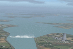
This float plane scene is based on the terra server. Lake Norman is in close proximity to the city of Charlotte, NC. The dam has dynamic spray and adjoining industry. A map of the state camp ground is included for your adding to my custom made scenery. I pulled this from my personal archives...
|
| Filename: |
denveroftheeast_4nc9_329778.zip |
| License: |
Freeware |
| Added: |
11th July 2015, 11:20:14 |
| Downloads: |
225 |
| Author: |
Rick Connolly |
| Size: |
3122kb |
|
|
Images related to this file:
|
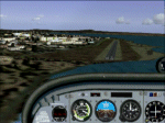
File Description:
This scenery was requested by Federico Malfu Sanchez, who also did all the legwork to find images and data, and as well did the complete Beta testing.
The area surrounding has been edited to help VFR pilots find their way. The whole LOD 8 tile the scenery is on has been resampled with SRTM3 data at LOD 13 level. The Rio Tercero lake has been configured to satellite images and rivers and roads follow their actual mapped courses.
Additionally the Rio Tercero dam and hydro electric plant, as well as other VFR relevant landmarks, have been included.
|
| Filename: |
rumipalv10.zip |
| License: |
Freeware, limited distribution |
| Added: |
12th May 2010, 00:19:55 |
| Downloads: |
306 |
| Author: |
Alf B. Meier |
| Size: |
1657kb |
|
|
|
Images related to this file:
|
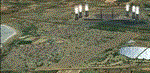
File Description:
Arnot Power Station, South Africa with photoreal textures and seasonal textures.
The power station, airfield building, objects and fences were all custom made in Gmax, while Rietkuil village (Arnot) is also represented by means of almost 800 hand placed autogen buildings. Arnot is also well known for the large amount of trees in the area, on approach to rwy 13 and lining the road seperating the village from the power station, and these are also represented by more than 4 000 hand placed trees. The "Ash-dam" south of the runway is also included.
|
| Filename: |
arnot.zip |
| License: |
Freeware, limited distribution |
| Added: |
16th November 2012, 23:45:27 |
| Downloads: |
514 |
| Author: |
Kobus van Wyk |
| Size: |
12152kb |
|
|
Images related to this file:
File Description:
The Chelsea Dams are on the Gatineau River, just north of Rockcliffe airfield. I have used the plural as while there is only one dam as such, there is a second generating station just south of the dam; so "it" is more generally called "the Chelsea Dams". The dams mark the point where, if you are flying south down the Gatineau River towards Rockcliffe, you should be either below 1,500 feet or talking to the Ottawa control tower. While not a reporting point as noted in the supplement notes about flying vfr in the Ottawa area the dams are still the natural reporting point when approaching Rockcliffe and announcing landing intentions. Plus they are a visible landmark from way off, so here they are.
| Filename: |
chelsea_dams.zip |
| License: |
Freeware, limited distribution |
| Added: |
14th February 2010, 23:11:15 |
| Downloads: |
253 |
| Author: |
Roger Wensley |
| Size: |
896kb |
|
|
File Description:
Lake Norman is in close proximity to the big city activities of Charlotte, North Carolina and 15 minutes north by car. The dam has dynamic spray effects and adjoining industry. This project lends itself to Runway12 and Lago additions. A map of the state camp ground is included for your adding to this. Scene is based on the terra server.
| Filename: |
denveroftheeast_4nc9.zip |
| License: |
Freeware |
| Added: |
27th August 2005, 23:18:58 |
| Downloads: |
1002 |
| Author: |
Rick Connolly |
| Size: |
3122kb |
|
|
File Description:
Detailed water features for South Africa, including coastline, dams, dam walls, rivers and streams. An updated railroad network is also included. (Re-upload of missing file)
| Filename: |
worx22.zip |
| License: |
Freeware, limited distribution |
| Added: |
1st July 2010, 14:42:45 |
| Downloads: |
1779 |
| Author: |
Aeroworx |
| Size: |
4681kb |
|
|
File Description:
This scenery will place Grand coulee dam in it's correct location and give it a more realistic appearance. It also provides a more realistic shoreline for Roosevelt Lake, the Spokane River, and the Columbia River from Lake Chelan to the Canadian border. Two versions are included; a stand alone version that will join with the default scenery, and a version that is compatible with Holger Sandmanns awesome southeastern British Columbia and the southern Canadian Rockies scenery. For eye candy I included a few of the marinas with docks and stationary boats and some optional AI boats that are cruising the lake and enjoying the scenery. This upload has the corrected readme file.
| Filename: |
grand_coulee.zip |
| License: |
Freeware |
| Added: |
3rd July 2004, 15:56:19 |
| Downloads: |
4119 |
| Author: |
Larry Silsbee |
| Size: |
720kb |
|
|
Images related to this file:
|
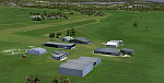
File Description:
This package will add a custom (Gmax) made Howick Airfield (FAHC), KwaZulu Natal, South Africa with photoreal textures and seasonal ground textures.
Howick is a small town in the KwaZulu Natal Midlands just off the N3 freeway which connects Johannesburg and Durban and home to the famous Howick waterfall. The Umgeni river falls 95m (311 ft) over the cliffs on the way to the Indian Ocean. The town is also home to the Midmar dam. This dam is very well known as being the location of the annual Midmar Mile swimming event which, in 2009, was recognized by the Guinness Book of World Records as the world's largest open water swimming event with 13 755 competitors taking part.
The sloped grass runway is aligned 16/34 and 825m long and sits at an elevation of 3 615ft. Both runways have obstacles on the approach, with powerlines 730m from the threshold of runway 16, while runway 34's approach have hills around 900m before the threshold. The sloped runway has been created in FS2004 within the limits of the simulator itself.
|
| Filename: |
buscen03.zip |
| License: |
Freeware, limited distribution |
| Added: |
15th January 2021, 20:25:51 |
| Downloads: |
161 |
| Author: |
Kobus van Wyk |
| Size: |
7866kb |
|
|
Images related to this file:

|
File Description:
KOGD-Ogden,Ut Take your sailboat to the Great Salt Lake inland sea or hike the many mountains and enjoy the vistas offered atop the lofty peaks. Visit the quiet mountain valley town of Eden to the east of KOGD with its annual balloon festival and summer fun on Pineview dam or spend the day shopping the shops of Brigham City to the north or Salt Lake City to the south. Fly over the Great Salt Lake to the west. See the Ogden airport come alive with this must have add-on. With the help of Google Earth and FS Earth I have recreated the Ogden airport, with its new taxiway A (from a site visit), and the surrounding cities and towns to look as real as possible. Made with Ultimate Terrain, but the airport should be ok with default FS9. (No guarantee though ;-) The scenery enhancements were made with Ultimate Terrain in place. I modified the landclass to look more like the real thing. The airport is very close to a exact replica of KOGD! The crane by the tower was there when I took the pictures so I included it.
|
| Filename: |
kogd_ogden,utah_266249.zip |
| License: |
Freeware |
| Added: |
15th December 2009, 00:45:07 |
| Downloads: |
715 |
| Author: |
Alan C. Heiner |
| Size: |
15966kb |
|
|
Images related to this file:
|
File Description:
KOGD-Ogden,Ut
Take your sailboat to the Great Salt Lake inland sea or hike the many mountains and enjoy the vistas offered atop the lofty peaks. Visit the quiet mountain valley town of Eden to the east of KOGD with its annual balloon festival and summer fun on Pineview dam or spend the day shopping the shops of Brigham City to the north or Salt Lake City to the south. Fly over the Great Salt Lake to the west.
See the Ogden airport come alive with this must have add-on. With the help of Google Earth and FS Earth I have recreated the Ogden airport, with its new taxiway A (from a site visit), and the surrounding cities and towns to look as real as possible.
Made with Ultimate Terrain, but the airport should be ok with default FS9. (No guarantee though ;-)
The scenery enhancements were made with Ultimate Terrain in place. I modified the landclass to look more like the real thing. The airport is very close to a exact replica of KOGD! The crane by the tower was there when I took the pictures so I included it.
|
| Filename: |
kogd_ogden,utah.zip |
| License: |
Freeware |
| Added: |
20th January 2009, 13:42:09 |
| Downloads: |
1328 |
| Author: |
Alan C. Heiner |
| Size: |
15966kb |
|
  |


