|
AVSIM Library - Search Results
|
|
Login | Register | About logging in and out
|
|
Searching for: 'dam' in Flight Simulator 2004 - Scenery and below.
|

|
|
|
|
|
|
Images related to this file:

|
File Description:
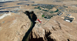
Another great place to visit for the VFR lover! Check out the canyons and mountains around Vernal. Watch out for the Dinosaurs! This file is an update to my old KVEL. Lots of new stuff.
Take a trip to North to visit Flaming Gorge Dam and lake. Be sure to take your fishing pole and don't forget the bait!
The DC-3's that stop there start at KBIL and KSLC. KVEL is airport #9 of the KBIL to KSLC Frontier Airlines 1950 flight schedule. You will need to get my KPOY airport to see them. I didn't want to duplicate the traffic file of the DC-3's so I chose KPOY as the main starting point of the DC-3's.
|
| Filename: |
kvel-vernal,ut.zip |
| License: |
Freeware |
| Added: |
17th May 2010, 04:38:32 |
| Downloads: |
609 |
| Author: |
Alan C Heiner |
| Size: |
4321kb |
|
|
Images related to this file:
File Description:
LPMO Morargil Airfield.
This is a certified airfield in the neighbourhood of Mora Village (North Alentejo) in the middle south of Portugal, about 4.5 miles SSE from Montargil dam. The house painting respects the traditional Alentejo houses.
This scenery is only compatible with Portugal Terrain from PTSIM (http://www.ptsim.com) and is based on digital pictures taken at the place, accurate real measures by Aerodromos de Portugal (http://www.pelicano.com.pt/zmapa.html) and Google Earth. Freeware. For Microsoft FS2004.NOT tested for FSX
| Filename: |
lpmo_morargil.zip |
| License: |
Freeware |
| Added: |
1st March 2013, 22:39:29 |
| Downloads: |
365 |
| Author: |
Joao A. Graca Ferreira |
| Size: |
8847kb |
|
|
|
File Description:
FS2004 Mark Twain Lake -- Hannibal, Mo. V3.
FS2004 scenery, From Bob's Hangar. An updated
version of my Mark Twain Lake Scenery for FS2004,
includes additions and new macros. New trees, built
in Terrian, no more flat shore lines. Natural bluffs.
Cannon Dam macro from EOD and actual digital photos.
Old downtown Hannibal Historic district, cobblestone
waterfront, restored boyhood home of Samuel Clemens,
(aka "Mark Twain"). Barge traffic on the Mississippi
River. Florida, Mo. with birthplace cabin of Mark Twain.
All shoreline attractions, and a typical farming and
ranching area of northeast Missouri. Includes three
upgraded default airports. Hannibal Municipal KHAE,
Wood Acres 7M01, and Samuel L. Clemens Memorial
MU00. This scenery works equally well in Fs2002.
By Robert Palmer
| Filename: |
mktwlkv3.zip |
| License: |
Freeware, limited distribution |
| Added: |
25th June 2004, 14:16:07 |
| Downloads: |
1657 |
| Author: |
Robert Palmer |
| Size: |
6225kb |
|
|
File Description:
Welcome to Omarama Airfield, situated 10 nautical miles West-North-West of the Benmore Hydro Dam, in
the Mckenzie Country region of the South Island of New Zealand.
Omarama is also known as the Glider Capitol of New Zealand.
The scenery also includes a representaion of the entire town of Omarama.
Requires some EZ Scenery Object Sets (see INSTALL instructions for details).
| Filename: |
omarama_airfield_nzoa.zip |
| License: |
Freeware, limited distribution |
| Added: |
22nd November 2008, 13:09:15 |
| Downloads: |
675 |
| Author: |
Lawrie Roache |
| Size: |
3375kb |
|
|
Images related to this file:
|
File Description:
This scenery covers the western part of Lake Powell, the city of Page (KPGA), the Vermillion Cliffs, Glenn Canyon just south of Glenn Canyon Dam, the northern part of Marble Canyon, Paria Canyon, Cockscomb, etc, etc. Spectacular! To explore the scenery depart from Page Municipal Airport (KPGA). High resolution versions of this scenery for FS9 and FSX (much sharper, but larger and multiple downloads) are available at www.blueskyscenery.com/CNY_South3West3.html . The screenies are taken from the high-res versions, so expect this version to be slightly more blurry. YourDonation@Work: Dedicated to William, Veit and Michele.
|
| Filename: |
cny_south3west3_2010_lr.zip |
| License: |
Freeware, limited distribution |
| Added: |
3rd March 2010, 21:26:32 |
| Downloads: |
1756 |
| Author: |
Gottfried Razek - blueskyscenery.com |
| Size: |
94625kb |
|
|
File Description:
Photo scenery for the Page, AZ area with Lake Powell and the Glen Canyon Dam. Includes AI traffic, FS9 water for the lake and updated AFCAD.
| Filename: |
page.zip |
| License: |
Freeware |
| Added: |
4th February 2007, 21:56:21 |
| Downloads: |
1665 |
| Author: |
Kevin Burns |
| Size: |
28359kb |
|
|
Images related to this file:
File Description:
This will not work without Ultimate Terrain, as the rivers and lakes just won't be there. The Paugan and Mercier Dams are on the Gatineau River in Quebec, north of Ottawa. Both of them are for power generation, rather than water conservation; the Paugan power generation building sits at the bottom of the sluiceway below the dam and appears far larger than the dam itself; there is a separate overflow sluice system nearby. The Paugan Dam is around 30 miles north up the river from Ottawa and the Mercier a further 70 miles. The Mercier holds back a huge and irregularly shaped volume of water known as the Reservoir Baskatong, with numerous branching arms and islands, and you will recognise where the dam must be long before you see it.
| Filename: |
gatineau_dams.zip |
| License: |
Freeware, limited distribution |
| Added: |
3rd May 2010, 00:11:21 |
| Downloads: |
270 |
| Author: |
Roger Wensley |
| Size: |
425kb |
|
|
File Description:
Navigation landmarks for pilots flying around Perth, in particular for pilots flying out of Jandakot Airport. Includes totally reworked coastline, Swan and Canning rivers, and the following nav points - Murdoch open space, Adventure World, Henderson Shipyards, Fremantle harbour, Pt Walter, Cottesloe, Canning, Shelley and Mt Henry bridges, Langley Park, Lake Monger and Herdsmen Lake, Canning Dam, all lakes south of Canning River (Bibra, Thompson etc), Penguin and Carnak Islands. For FS2004 Only, to be used with our Sth West landclass and Jandakot airport. http://www.westsim.com.au/
| Filename: |
pma2004.zip |
| License: |
Freeware, limited distribution |
| Added: |
15th December 2003, 16:13:32 |
| Downloads: |
3041 |
| Author: |
Westsim Design Group - Derek Kippo and Jarrad Marshall |
| Size: |
418kb |
|
|
File Description:
Replacement files for water bodies of eastern South Africa, in and near the Drakensberg Range (S28.1-29.5 E28.3-30.0). Natural and man-made lakes are now in their accurate position and elevation. Includes the Katse Dam reservoir in Lesotho as well as about 100 smaller lakes in Lesotho and western Natal not present in the FS default scenery. Based on a watermask derived from Landsat 7 ETM+ satellite data and compiled with a beta version of Jim Keir's "Slartibartfast" utility. Meant to be used with the Aeroworx SRTM LOD9 South Africa mesh.
| Filename: |
natal_w.zip |
| License: |
Freeware, limited distribution |
| Added: |
8th May 2004, 02:43:38 |
| Downloads: |
6175 |
| Author: |
Holger Sandmann, Aeroworx |
| Size: |
464kb |
|
|
File Description:
FS2004 scenery, Roosevelt, Lake Arizona
From Bobs Hangar, this is a large scenery of the Roosevelt
Lake and Dam area. Includes Roosevelt Dam, The Grapevine
Airstrip 51AZ, Roosevelt Lake Resort, and also the Visitors
Center and Marina. There is a camp ground on the beach near
the northend of the lake. There are three dynamic aircraft
Flights in this scenery. This scenery also works well in FS2002.
All textures included.
| Filename: |
rsvlt_lk.zip |
| License: |
Freeware, limited distribution |
| Added: |
3rd December 2003, 08:20:57 |
| Downloads: |
3064 |
| Author: |
Robert Palmer |
| Size: |
6440kb |
|
  |


