
Where Flight Simulation Enthusiasts Gather from Around the World!
AVSIM Library - Search Results

| Category: X-Plane - Scenery | |
| South African Air Force Memorial - Pretoria, South Africa |

|
Images related to this file:
File Description:

A photoreal Gmax representation of the South African Air Force Memorial on the hill just north of Swartkop AFB (FASK) in Pretoria, South Africa.
All scenery elements are custom made with photoreal textures and no libraries are needed. This package will also replace the default "ground" around the airport (FASK) to make it blend better with the surrounding area (default ground texture).
| Filename: | South_African_Air_Force_Memorial__Pretoria_South_A.zip |
| License: | Freeware, limited distribution |
| Added: | 2nd September 2016, 21:15:12 |
| Downloads: | 104 |
| Author: | Kobus van Wyk, Aeroworx |
| Size: | 550.37 KB |
| Category: X-Plane - Scenery | |
| Elandshoogte Airfield, South Africa |
|
Images related to this file:
File Description:

A Gmax representation of Elandshoogte Airfield, near the Sappi factory outside Ngodwana, Mpumalanga, South Africa with photoreal textures.
Elandshoogte airfield is a small airfield with 2 grass runways both measuring under 700m each. The airfield is situated between the trees of the lush Sappi forests on top of a hill with both runways sloping downwards into valleys and is used by the "fire-bombers" to fight forest fires.
| Filename: | Elandshoogte_Airfield_South_Africa.zip |
| License: | Freeware, limited distribution |
| Added: | 28th October 2016, 21:28:41 |
| Downloads: | 87 |
| Author: | Kobus van Wyk, Aeroworx |
| Size: | 11.12 MB |
| Category: X-Plane - Scenery | |
| Piet Retief Airfield (FAPF), South Africa |
|
Images related to this file:
File Description:
A Gmax representation of Piet Retief Airfield, Mpumalanga, South Africa with photoreal textures.
Piet Retief airfield is a small airfield with a grass/dirt runway measuring 1 371m. The airfield is situated between the trees of the lush Sappi forests between the town of Piet Retief and the Swaziland border at an elevation of 4 420ft. There is an NDB for a "Breakcloud" procedure onto rwy 15.
| Filename: | Piet_Retief_Airfield_FAPF_South_Africa.zip |
| License: | Freeware, limited distribution |
| Added: | 4th November 2016, 22:18:43 |
| Downloads: | 77 |
| Author: | Kobus van Wyk, Aeroworx |
| Size: | 1.96 MB |
| Category: X-Plane - Scenery | |
| XP11 German Scenery EDHK 2018+ Kiel-Holtenau |
|
File Description:
The small Zip-file will include a link for scenery download, because the scenery file size is above 500 Mbyte. Just follow the link and download EDHK 2018. This is an "install and fly" version, everything you need is already included (*see info below) and I will continously update the scenery. The story, in November 2012 the German MFG5 (Marineflieger-Geschwader) was relocated to Nordholz (ETMN). This was the end of the main military use in the southern and eastern part of the airport. Because the German harbor city Kiel needs living space for their citizens, opponents of the airport tried to convince citizens and politics to close the airport and to create there living space instead. In 2018 the citizen of Kiel voted with a citizen’s decision with the result that the majority voted for the preservation of the traditional airport. Personally, I am very happy with this decision. On the area of the airport some companies are settled, their employees should be able to sleep a little better now. In addition, there will certainly be future investments in the airport due to the election results. Since the airport has been financially in the red for years, the operator of the airport, the Port of Kiel Flughafen GmbH & Co. KG has converted large areas of the airport as parking area. These parked vehicles are part of the constantly increasing cruise ship operations within Kiel, making it possible for passengers to safely park their vehicles for extended periods of time. The taxiways “A†and “D†of EDHK are no longer in operation. This was of course taken into account in my scenery. The access to this taxiway was marked as in the original by yellow "X". The taxiway lighting was also turned off there. The on-site Luftsportverein (LSV) uses above the runway 08/26 an individually marked grass runway (not official), I called it 08S/26S and it is for the winch launch of their gliders only. The size of this provisional winch runway is about 820x20m. A glider takeoff by towing aircraft is usually handled by the Runway 08/26.(*) There is no copyright infringement, since I have received all the needed permissions to use the listed objects/libraries full or in parts within my scenery, the same for the single objects or non-Library bound objects/elements. I got all these permissions in writing from each individual author/rights holder. Take the time and read the full, included descritpion, please. If you have question, ask me first!
| Filename: | XP11_German_Scenery_EDHK_2018_KielHoltenau.zip |
| License: | Freeware |
| Added: | 28th November 2018, 22:46:11 |
| Downloads: | 69 |
| Author: | Marco Moschet |
| Size: | 1.3 KB |
| Category: X-Plane - Scenery | |
| XP11 German Scenery EDHK 2018+ Kiel-Holtenau |
|
Images related to this file:
File Description:
The small Zip-file will include a link for scenery download, because the scenery file size is above 500 Mbyte. Just follow the link and download EDHK 2018. This is an "install and fly" version, everything you need is already included (*see info below) and I will continously update the scenery. The story, in November 2012 the German MFG5 (Marineflieger-Geschwader) was relocated to Nordholz (ETMN). This was the end of the main military use in the southern and eastern part of the airport. Because the German harbor city Kiel needs living space for their citizens, opponents of the airport tried to convince citizens and politics to close the airport and to create there living space instead. In 2018 the citizen of Kiel voted with a citizen’s decision with the result that the majority voted for the preservation of the traditional airport. Personally, I am very happy with this decision. On the area of the airport some companies are settled, their employees should be able to sleep a little better now. In addition, there will certainly be future investments in the airport due to the election results. Since the airport has been financially in the red for years, the operator of the airport, the Port of Kiel Flughafen GmbH & Co. KG has converted large areas of the airport as parking area. These parked vehicles are part of the constantly increasing cruise ship operations within Kiel, making it possible for passengers to safely park their vehicles for extended periods of time. The taxiways “A†and “D†of EDHK are no longer in operation. This was of course taken into account in my scenery. The access to this taxiway was marked as in the original by yellow "X". The taxiway lighting was also turned off there. The on-site Luftsportverein (LSV) uses above the runway 08/26 an individually marked grass runway (not official), I called it 08S/26S and it is for the winch launch of their gliders only. The size of this provisional winch runway is about 820x20m. A glider takeoff by towing aircraft is usually handled by the Runway 08/26.(*) There is no copyright infringement, since I have received all the needed permissions to use the listed objects/libraries full or in parts within my scenery, the same for the single objects or non-Library bound objects/elements. I got all these permissions in writing from each individual author/rights holder. Take the time and read the full, included descritpion, please. If you have question, ask me first!
| Filename: | XP11_German_Scenery_EDHK_2018_KielHoltenau.zip |
| License: | Freeware |
| Added: | 29th November 2018, 19:24:38 |
| Downloads: | 65 |
| Author: | Marco Moschet |
| Size: | 1.3 KB |
| Category: X-Plane - Scenery | |
| Hawaii Photoreal - Niihau, Lehua and Kaula |
|
File Description:
The Hawaii Photoreal project from FSX is proud to bring a gorgeous island to X-Plane, Niihau! This is the first Hawaii Photoreal Scenery available with HD Mesh for X-Plane 10! Installation instructions are included. You must download both files for full HD Mesh experience. This scenery will not align correctly with default terrain and coastlines or those available with AlpilotX's HD Mesh 2. It should also be noted that this scenery will explode upon decompression - the true size of the folder is 341MB, whereas the download size is only 88MB. Make sure you aren't almost out of space. Niihau for X-Plane 10 includes customized HD Mesh for the entire island, including Lehua and Kaula. This isn't just processed DEM data - we have reviewed and perfected the coastlines and cliffs for ideal appearance. Please show support for this project by considering donating to the Hawaii Photoreal Project through the website.
| Filename: | Hawaii_Photoreal__Niihau_Lehua_and_Kaula.zip |
| License: | Freeware, limited distribution |
| Added: | 27th March 2016, 19:27:43 |
| Downloads: | 149 |
| Author: | Colin Stepney |
| Size: | 86.31 MB |
| Category: X-Plane - Scenery | |
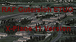
| RAF Gutersloh ETUO |
|
Images related to this file:
File Description:
File Description:
X-Plane 11 Scenery - RAF Gutersloh AB (ICAO: ETUO)
The scenery represents the former airbase of RAF Gutersloh, one of the most populated military bases in West Germany during the Cold War, due to its location near the former East/West border. This scenery reflects the era at the end of the 1980s/beginning of the 90s, when the Harrier GR3 was in operation there, along with Chinook helicopters.
The airfield was built in 1935 and was used by the German Air Force during WW2, flying the Junkers JU-86 and Heinkel H-111. The first British squadrons were stationed there from 1947, with Mosquitos, Vampires and then Canberras.
The first Harrier arrived at Gutersloh in January 1977 and 3 and 4 Squadrons became resident until their farewell in 1993, after the cold war had ended. The airfield is currently used by the British army, but they will leave in 2014 to relinquish the area to the Government of Gutersloh for civil usage.
High detailed scenery by Manfred Schyma and Pete Beeby, supported by the Airfield Construction Group. X-Plane Version designed by Dietmar Hanne
| Filename: | RAF_Gutersloh_ETUO.zip |
| License: | Freeware |
| Added: | 25th May 2018, 23:53:43 |
| Downloads: | 264 |
| Author: | Dietmar Hanne |
| Size: | 142.94 MB |
| Category: X-Plane - Scenery | |
| xTreme Trees Demo - Florida and Puerto Rico |
|
Images related to this file:
File Description:
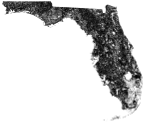
Welcome to a new age of immersion, Presenting X-Treme Trees for X-Plane! Current USGS Treeline data has been handwritten into custom overlays to give proper representation of treelines and vegetation to another level!
This fully functional demo includes Florida, Puerto Rico and slices of bordering Georgia. See included readme for details regarding volume 1 of the 2 volume series!
SYSTEM REQUIREMENTS:
- OS: Windows, Mac OS X or Linux
- X-Plane version: 10.25 or higher
- Architectures: 32 and 64-bit
| Filename: | xTreme_Trees_Demo__Florida_and_Puerto_Rico.zip |
| License: | Freeware |
| Added: | 26th March 2018, 17:10:44 |
| Downloads: | 64 |
| Author: | Brian Bash |
| Size: | 66.18 MB |
| Category: X-Plane - Scenery | |
| ENNM - Namsos Airport - Namsos, Norway |
|
Images related to this file:
File Description:
This Namsos scenery corresponds to the current Airport Layout of ENNM. The near surroundings are designed based on a satellite photo so that VFR flights and VFR orientation should be very easy. The second bridge a bit far west of the airport is included, also the City of Namsos, a cruise ship dock and the marina south of the Namsos Bridge.
I used some parts of freeware libraries, which are already included in this package.
The airport buildings are converted from the famous FS2004 scenery from Kjell Arild Bersaas & Arne Sundsboe.
I did some small changes which were absolutely necessary to fit the new airport layout. Finally I only deleted a fence which blocked the new apron.
This scenery is converted from my ENNM-FSX scenery and the reworked with WED and OverlayEditor. The library "OpenSceneryX" must be installed first:
http://www.opensceneryx.com/
| Filename: | ENNM__Namsos_Airport__Namsos_Norway.zip |
| License: | Freeware |
| Added: | 17th May 2015, 08:59:30 |
| Downloads: | 140 |
| Author: | Wolfgang Allers |
| Size: | 16.75 MB |
| Category: X-Plane - Scenery | |
| EPGO - Goraszka 2007 for X-Plane 8 |
|
Images related to this file:
File Description:
EPGO GORASZKA 2007 SCENERY FOR X-PLANE 8
----- ABOUT THE AIRPORT -----
EPGO Goraszka airport is located 12nm (20km) south-east of Warsaw downtown and Warsaw Frederic Chopin International Airport. It was built in 1994 and belongs to General Aviation company, which offers aero-taxi flights, air transport and special flights (air photo, patrol) and airport services. The airport has a 800m-long runway and a lightened helipad, which can be used by helicopters up to 5700kg weight. General Aviation's fleet includes Antonov AN-2, PZL-104 Wilga 80, Bell 407 and 427. Since 1996 the International Air Picnic Goraszka is organized every year by "Polish Eagles" Foundation created on initiative of Zbigniew Niemczycki.
----- SCENERY FEATURES -----
This airstrip has never been included in any of X-plane series default airports list and this is the first, detailed scenery of EPGO. Main features of the scenery are:
-Ground photo texture for the surrounding area - perfect for VFR approaches (four seasons + night textures)
-Airport ground high resolution textures - feel the grass when taxiing (four seasons + night textures)
-Highly detailed 3D objects, all photo textured - we made over 300 photos to have them all realistically textured
-Detailed autogen for the whole area - almost every building and every tree
-Tower view - feel like an air traffic controller
| Filename: | EPGO__Goraszka_2007_for_XPlane_8.zip |
| License: | Freeware, limited distribution |
| Added: | 27th October 2015, 15:16:51 |
| Downloads: | 25 |
| Author: | Drzewiecki Design |
| Size: | 50.53 MB |
© 2001-2026 AVSIM Online
All Rights Reserved
Privacy Policy |