
Where Flight Simulation Enthusiasts Gather from Around the World!
AVSIM Library - Search Results

| Category: Flight Simulator 2004 - AI Flight Plans | |
| Iberia - Summer 2008 |

|
File Description:
Summer 2008 schedule for Iberia, based on week 0837 (9/08/2008 -> 9/14/2008). Includes flights operated by Audeli Air. Total size 3588 weekly legs / 118 aircrafts used.
| Filename: | ibe_su08.zip |
| License: | Freeware, limited distribution |
| Added: | 21st July 2008, 13:17:11 |
| Downloads: | 1,702 |
| Author: | Yohann Baptiste |
| Size: | 54 KB |
| Category: Flight Simulator 2004 - AI Flight Plans | |
| Saudi Arabian Airlines Winter 2007/2008 |
|
File Description:
Winter 2007/2008 schedule for Saudi Arabian Airlines, based on week 0747 (11/19/2007 -> 11/25/2007). Includes Hajj flights scheduled that precise week: from Casablanca, Tehran, Delhi, Kuala Lumpur and Jakarta to Medinah.
| Filename: | sva_wi07-08.zip |
| License: | Freeware, limited distribution |
| Added: | 24th October 2007, 13:50:07 |
| Downloads: | 3,801 |
| Author: | Yohann Baptiste |
| Size: | 44 KB |
| Category: Flight Simulator 2004 - Scenery | |
| ZGBS - Bose Airport |
|
Images related to this file:
File Description:
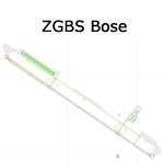
A google-earthed scenery for Bose airport (alternate spelling: Baise) which is missing in FS9 stock version, with basic default terminal & tower, and taxisigns.
All features accurately placed/shaped according to sat imagery. Navaids valid as AIRAC 1110.
No approach coded.
Current scheduled operators at ZGBS: China Express Airlines.
| Filename: | zgbs.zip |
| License: | Freeware, limited distribution |
| Added: | 13th January 2012, 00:34:03 |
| Downloads: | 591 |
| Author: | Yohann Baptiste |
| Size: | 419 KB |
| Category: Flight Simulator 2004 - AI Flight Plans | |
| AiRUnion - Winter 2007-08 |
|
File Description:
Winter 2007/2008 schedule for AiRUnion (Russia), based on week 0804 (1/21/2008 -> 1/27/2008). AiRUnion is the merging (not yet completed) of five russian airlines: Kras Air (7B/KJC), Domodedovo Airlines (E3/DMO), Samara Airlines (E5/BRZ), SIAT Sibaviatrans (5M/SIB) and Omskavia (N3/OMS). Total size 683 weekly legs / 53 aircrafts used.
| Filename: | AiRUnion__Winter_200708.zip |
| License: | Freeware, limited distribution |
| Added: | 29th January 2008, 22:47:30 |
| Downloads: | 2,185 |
| Author: | Yohann Baptiste |
| Size: | 16.87 KB |
| Category: Flight Simulator 2004 - Scenery | |
| ZGOW - Jieyang/Chaoshan |
|
Images related to this file:
File Description:
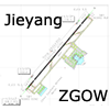
A basic scenery for Jieyang/Chaoshan airport which opened on Dec 18th 2011, replacing old Shantou/Waishan airport with the same ICAO/IATA codes: ZGOW/SWA.
All features accurately placed/shaped according to Chinese AIP SUP from Dec 15th 2011, with basic default terminal & tower, taxisigns, jetways, and ILS approach code for AI & UI users.
Scheduled operators at ZGOW: China southern (focus city), China Eastern, Tianjin Airlines, Air Chinan & Shandong Airlines.
| Filename: | zgow.zip |
| License: | Freeware, limited distribution |
| Added: | 29th December 2011, 23:15:11 |
| Downloads: | 955 |
| Author: | Yohann Baptiste |
| Size: | 504 KB |
| Category: Flight Simulator 2004 - Scenery | |
| Guatemala & Honduras SRTM Mesh Part 1 |
|
File Description:
This terrain mesh scenery was made to fit Jozef Kusters' Nicaragua mesh on its south-eastern edges. It covers Guatemala, western & northern Honduras (including Isl de la Bahia - Roatan), Belize and Salvador. Based on SRTM Data (3 arc/sec), generated with Matthew Styles's program "SRTM To BGL v1.04", sampled to LOD9 resolution (76m) with 5 interpolation passes. While tested under Fs2004, this mesh should also run in FS2002.
This part contains Guatemala-S.BGL. See guatemala_honduras_mesh_pt1.jpg for .BGL files coverage.
| Filename: | guatemala_honduras_mesh_pt1.zip |
| License: | Freeware |
| Added: | 30th September 2003, 15:19:59 |
| Downloads: | 6,973 |
| Author: | Yohann Baptiste |
| Size: | 16.92 MB |
| Category: Flight Simulator 2004 - Scenery | |
| Northern Venezuela SRTM Mesh Part 1 |
|
File Description:
This terrain mesh scenery covers north of Venezuela (southern boundary is 8°48'N) and Dutch caribeans: Aruba, Curacao & Bonaire islands.
Based on SRTM Data (3 arcsec, 90m), generated with Matthew Styles's program "SRTM To BGL v1.04", sampled to LOD9 resolution (76m) with 5 interpolation passes.
This part contains Venezuela-NE.bgl, Venezuela-N.bgl plus all islands. See venezuela_n_mesh_pt1-1.jpg for the .BGL files coverage.
| Filename: | venezuela_n_mesh_pt1.zip |
| License: | Freeware |
| Added: | 7th October 2003, 18:15:30 |
| Downloads: | 8,959 |
| Author: | Yohann Baptiste |
| Size: | 13.93 MB |
| Category: Flight Simulator 2004 - Scenery | |
| Northern Venezuela SRTM Mesh part 2 |
|
File Description:
This terrain mesh scenery covers north of Venezuela (southern boundary is 8°48'N) and Dutch caribeans: Aruba, Curacao & Bonaire islands.
Based on SRTM Data (3 arcsec, 90m), generated with Matthew Styles's program "SRTM To BGL v1.04", sampled to LOD9 resolution (76m) with 5 interpolation passes.
This part contains Venezuela-NW.bgl. See venezuela_n_mesh_pt2-1.jpg for the .BGL files coverage.
| Filename: | venezuela_n_mesh_pt2.zip |
| License: | Freeware |
| Added: | 7th October 2003, 18:19:24 |
| Downloads: | 8,611 |
| Author: | Yohann Baptiste |
| Size: | 14.31 MB |
| Category: Flight Simulator 2004 - Scenery | |
| WADL - Praya Lombok International Airport |
|
Images related to this file:
File Description:
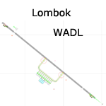
A basic scenery for new Lombok Intl airport which is missing in FS9 stock version. WADL replaced old Mataram airport (WADA/WRRA/AMI) which closed on september 30th 2011.
All features accurately placed/shaped according to charts from AIRAC cycle 1113.
Includes basic default terminal, tower, taxisigns, and the following xml-coded approaches for AI & UI: ILS 13, RNAV 13 & RNAV 31.
| Filename: | wadl.zip |
| License: | Freeware, limited distribution |
| Added: | 10th January 2012, 14:20:07 |
| Downloads: | 3,338 |
| Author: | Yohann Baptiste |
| Size: | 309 KB |
| Category: Flight Simulator 2004 - Scenery | |
| Europe SRTM mesh part 01: LOD7 buffer mesh |
|
File Description:
Europe SRTM LOD9 mesh part 1 of 13: This is a LOD7 mesh covering the whole Europe from 35°N to 60°N and 12°W to 30°E, to be used as a buffer mesh in conjection with the LOD9 mesh. This Europe SRTM project was optimized for the lowest HDD space use: Each part macthing exactly the boundaries of its neighbors, you'll have a complete corevage of Europe without gap or overlapping scenery. Based on SRTM Data v1 and v2 (3 arcsec, 90m) and sampled to LOD7 resolution (300m). Each SRTM tile was carefully checked and repaired with Blackart v4.02: water areas are now flattened (lighter mesh), and SRTM voids were treated taking advantage of Blackart's sophisticated interpolation algorithm. When required, biggest voids were patched with oversampled SRTM 30 arcsec data and/or manual input.
| Filename: | eur_srtm_01.zip |
| License: | Freeware, limited distribution |
| Added: | 19th October 2005, 16:11:05 |
| Downloads: | 19,028 |
| Author: | Yohann Baptiste |
| Size: | 50.28 MB |
© 2001-2025 AVSIM Online
All Rights Reserved