
Where Flight Simulation Enthusiasts Gather from Around the World!
AVSIM Library - Search Results

| Category: Flight Simulator 2002 - Miscellaneous Files | |
| FS2002 Real Weather for 09/18/2003 - Hurricane Isabel |

|
File Description:
Hurricane Isabel struck the state of Virginia with tremendous force. Using any of the WX files included you can see what it’s like to fly in such conditions. Visibility at some airports goes down to 1/16th of a mile, giving you fantastic instrument practice! The wind speeds peak at 60 Knots in some areas.
Full instructions included! Test your instrument flying skills!
| Filename: | isabel.zip |
| License: | Freeware |
| Added: | 23rd September 2003, 02:11:38 |
| Downloads: | 1,176 |
| Author: | Darren Boon |
| Size: | 1.41 MB |
| Category: Flight Simulator X - Utilities | |
| Taxi Navigation (+Destination Weather Reporter) for FSX/FS9 V1.0 |
|
Images related to this file:
File Description:

Do you prepare airport charts of every airport you visit, or just follow the progressive taxi to do taxiing?
This utility will make taxiing easy and realistic by providing simple taxi navigation information in text.
While taxiing, press "Ctrl + Shift + X", then taxi navigation information will be displayed.
It includes current taxiway name, intersecting taxiways' name and distance
(e.g. "On R7 : R2 (250m), R1 (643m), A (748m), A7 (748m)").
And one more thing, it also provides destination weather report.
It can be very helpful to set up exact T/D(Top of Descent), by assuming expected runway with wind information.
Enter destination airport before flight, and press "Ctrl + Shift + W" while flying,
then destination weather information will be displayed.
It looks like METAR and includes wind direction and speed, visibility, temperature, dew point and pressure
(e.g. "RKPK 29403KT 47SM 32/23 1010mb").
| Filename: | Taxi_Navigation_Destination_Weather_Reporter_for_F.zip |
| License: | Freeware |
| Added: | 3rd August 2012, 06:47:24 |
| Downloads: | 2,929 |
| Author: | Dongjin Shin |
| Size: | 4.88 MB |
| Category: Flight Simulator X - Scenery | |
| FAGG - SA Weather Service, George Airport - George, South Africa |
|
File Description:
This is a representation of the South African Weather Service Office at George FAGG) airport, South Africa.
Very elementary object created with Gmax by Johan Kotze.
Works in FS2004 and FSX.
| Filename: | FAGG__SA_Weather_Service_George_Airport__George_So.zip |
| License: | Freeware |
| Added: | 13th September 2015, 10:49:16 |
| Downloads: | 334 |
| Author: | Johan Kotze |
| Size: | 611.82 KB |
| Category: Flight Simulator 2004 - Flight Plans | |
| Idaho Hops |
|
File Description:
21 short hops around the state of Idaho. Varying weather, time of day and seasons. Most flights are under 30 minutes, depending on the aircraft you choose.
| Filename: | idhops.zip |
| License: | Freeware |
| Added: | 23rd November 2003, 04:48:30 |
| Downloads: | 1,003 |
| Author: | Lynn Bergan |
| Size: | 423 KB |
| Category: Flight Simulator X - Scenery | |
| EETN - Tallinn, Estonia v3.5 |
|
Images related to this file:
File Description:
This software package contains the latest version of Tallinn airport and surrounding obstacles. It is backward compatible with FSX SP2. The scenery was highly optimized to allow all-weather operations. NAV data including SIDs/STARs, waypoints and RNAV routes within Tallinn FIR are up to date (AIRAC effective date 28 MAY 2015). Real NAV charts were helpfully provided by the Estonian ANS (EANS).
Weather Explorer is a stand-alone program requiring Microsoft .NET Framework 4.
| Filename: | tallinn_eetn_fsx_v35.zip |
| License: | Freeware |
| Added: | 7th May 2015, 21:56:01 |
| Downloads: | 13,965 |
| Author: | Stas Neznamov |
| Size: | 50.35 MB |
| Category: Flight Simulator 2004 - Flight Plans | |
| Oregon Hops |
|
File Description:
21 short hops around Oregon, most flights are under 30 minutes with a twin engine plane. VFR and IFR with many differnt season, weather and time of day changes.
| Filename: | orhops.zip |
| License: | Freeware |
| Added: | 9th November 2003, 02:54:17 |
| Downloads: | 1,251 |
| Author: | Lynn Bergan |
| Size: | 415 KB |
| Category: Flight Simulator X - Missions | |
| ElliotIslandShuttle.zip |
|
File Description:
Beginner helicopter mission. A helicopter company located at YBUD airport provides shuttle services. Today's flight is to Lady Elliot Island. The weather is CAVU and the winds are light.
| Filename: | elliotislandshuttle.zip |
| License: | Freeware |
| Added: | 18th December 2021, 04:57:49 |
| Downloads: | 73 |
| Author: | helomissionman |
| Size: | 4.37 MB |
| Category: Flight Simulator X - Missions | |
| UltimaThuleLodge.zip |
|
File Description:
Beginner helicopter mission. A helicopter company located at 15Z airport provides shuttle services to the Ultima Thule Lodge in Alaska. The weather is CAVU and the winds are light.
| Filename: | UltimaThuleLodgezip.zip |
| License: | Freeware |
| Added: | 18th December 2021, 04:57:56 |
| Downloads: | 78 |
| Author: | helomissionman |
| Size: | 6.29 MB |
| Category: Miscellaneous Files - General Utilities | |
| easySatPix |
|
Images related to this file:
File Description:
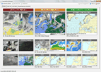
Windows-Software that retrieves weather charts (Sat-Pix, Sig-WX, SFC-Analysis, rain, snow, icing, thunderstorm, winds..), NOTAMS and METAR. Currently Europe is
covered, worldwide coverage soon by auto-update.
| Filename: | easysatpix.zip |
| License: | Freeware |
| Added: | 31st March 2011, 02:03:06 |
| Downloads: | 1,164 |
| Author: | Wilhelm Drotleff |
| Size: | 224 KB |
| Category: Flight Simulator X - Missions | |
| Short VFR trip to Lake Chelan |
|
Images related to this file:
File Description:
Hello,
Welcome. See if you can get from Pangborn Memorial to a local airport by air. Weather is clear skies this Sunday morning at 7.30am. See "readme" for installation instructions.
| Filename: | contents.zip |
| License: | Freeware |
| Added: | 9th September 2012, 21:03:39 |
| Downloads: | 327 |
| Author: | Mr. Pierre G. Shlimon |
| Size: | 1.86 MB |
© 2001-2025 AVSIM Online
All Rights Reserved