
Where Flight Simulation Enthusiasts Gather from Around the World!
AVSIM Library - Search Results

| Category: Flight Simulator 2002 - AFCAD Files | |
| Paro Additional Gates |

|
File Description:
This file adds more gates to Paro Airport, VQPR.
| Filename: | vqpr1.zip |
| License: | Freeware |
| Added: | 19th September 2004, 17:26:27 |
| Downloads: | 137 |
| Author: | Felipe César Rosa Oliveira |
| Size: | 1 KB |
| Category: Flight Simulator 2004 - AFCAD Files | |
| Paro (VQPR) |
|
File Description:
Reviewed AFCAD for Paro scenery made by David Cuvillier (paro.zip), available here at AVSIM.
| Filename: | dc_vqpr_afcad.zip |
| License: | Freeware |
| Added: | 12th January 2010, 19:17:21 |
| Downloads: | 743 |
| Author: | Filipe Fonseca |
| Size: | 1 KB |
| Category: Flight Simulator X - Missions | |
| ParoValleyBhutan.zip |
|
File Description:
Helicopter mission. A helicopter located at VQPR airport provides services. Take a group of tourists out to visit the Paro Dzong and the Tiger's Nest.
| Filename: | ParoValleyBhutanzip.zip |
| License: | Freeware |
| Added: | 28th January 2023, 03:43:14 |
| Downloads: | 79 |
| Author: | helomissionman |
| Size: | 5.78 MB |
| Category: Flight Simulator 2004 - Scenery | |
| Paro Airport VQPR, Bhutan |
|
Images related to this file:
File Description:
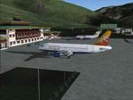
Enjoy this new scenery located inside himalyan mountain. Paro airport is the only international airport in Bhutan and one company operates there : DRUK AIR, the Royal Bhutan Airlines. Try taking off and landing there with one of the two A319 and two BAe-146 operated by DRUK AIR and enjoy mountain trekking in this magnificient contry !!
| Filename: | paro.zip |
| License: | Freeware |
| Added: | 12th January 2010, 20:16:14 |
| Downloads: | 13,529 |
| Author: | David Cuvillier |
| Size: | 1.67 MB |
| Category: Flight Simulator X - AFCAD Files | |
| VQPR - Paro Intl Airport,Tibet |
|
Images related to this file:
File Description:
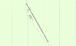
A modification of default Paro Intl Airport, Tibet for FSX using ADE with information from google earth. Addon terrain mesh is required as default FSX mesh is incorrect and makes the airport unusable.
| Filename: | vqpr.zip |
| License: | Freeware |
| Added: | 2nd September 2013, 13:29:20 |
| Downloads: | 537 |
| Author: | Himanshu Singh |
| Size: | 3 KB |
| Category: Flight Simulator 2004 - AFCAD Files | |
| VQYP - Bhutan Airport |
|
File Description:
This is the proposed second airport for Bhutan and is located in the Yongphulla region of Bhutan. You can set up flight plans between VQPR and VQYP to provide service to the Eastern Region of Bhutan. The airport does not have buildings ,but it has parking spaces for several aircraft. This is freeware and public use only.
| Filename: | VQYP__Bhutan_Airport.zip |
| License: | Freeware |
| Added: | 14th January 2013, 22:14:19 |
| Downloads: | 229 |
| Author: | James Curtis |
| Size: | 5.66 KB |
| Category: Flight Simulator 2004 - Miscellaneous Files | |
| Bhutan Paro Airport (VQPR, PBH) Terminal Procedures SID/STAR v.1.2 |
|
File Description:
Here it the PMDG terminal procedures of Bhutan Paro Airport v.1.2. The airport is located in Bhutan. This update is make a correction of a waypoint called "TAKTI".
All text is available under the terms of the GNU Free Documentation License.
| Filename: | pmdg_vqpr_sidstar_v1.2.zip |
| License: | Freeware, limited distribution |
| Added: | 13th November 2007, 18:50:38 |
| Downloads: | 1,190 |
| Author: | Thomas Lau |
| Size: | 448 KB |
| Category: Flight Simulator 2002 - Flight Plans | |
| 35RTWest |
|
File Description:
An FS2002 GPS flight Plan. The 35th in a series of Round the World flight plans for the FS2002 default scenery. Depart Paro (VQPR) runway 33, Bhutan and arrive 1 hour 02 minutes later at Tribhuvan International (VNKT) runway 02, Nepal. A steep takeoff to avoid the banking around the runway is followed by a climb up a valley before passing through a gap in the snow capped mountain peaks at FLl90. An optional flight situation file is provided to assist inexperienced pilots with this very tricky departure. At the highest point in the flight, FL280, you will still be overlooked as you pass the snow capped peak of Everest. The flight briefing (Word and text) is for a B737-400, it contains climb, cruise, top of descent and fuel loading details, waypoint timings and destination details.
| Filename: | 35rtwest.zip |
| License: | Freeware |
| Added: | 13th July 2002, 18:23:40 |
| Downloads: | 1,390 |
| Author: | The Ancient Brit |
| Size: | 57 KB |
| Category: Flight Simulator 2002 - Flight Plans | |
| 34RTWest |
|
File Description:
An FS2002 GPS flight Plan. The 34th in a series of Round the World flight plans for the FS2002 default scenery. Depart Guwahati runway 02, India and arrive 1 hour 04 minutes later at Paro (VQPR) runway 33, Bhutan. A quiet and gentle flight, at least for the first 14 minutes then on entering a deep valley to start a pass storming climb into the snow capped mountains the mood of the flight changes. A session of dodging through gaps in the peaks concludes with a ‘Dive Bomber” VFR finals into a airport surrounded by very high ground and with its runway in a deep pit in a valley bottom, brings the session to an end. Pilots who have so far enjoyed the brand of fun and nonsense I call flight planning, will not be disappointed with this flight. The flight briefing (Word and text) is for a B737-400, it contains climb, cruise, top of descent and fuel loading details, waypoint timings and destination details.
| Filename: | 34rtwest.zip |
| License: | Freeware |
| Added: | 7th July 2002, 19:09:58 |
| Downloads: | 1,055 |
| Author: | The Ancient Brit |
| Size: | 38 KB |
| Category: Flight Simulator X - Scenery | |
| Bhutan Airports and Paro Valley |
|
Images related to this file:
File Description:
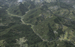
This project adds and updates all of the airports of Bhutan. Bathpalathang (VQBT) and Gelephu (VQGP) are added, Yongphulla (VQ10) is updated and recoded as VQTY, and Paro (VQPR) is fully updated to reflect current satellite imagery. These are all fully functioning AI airports as well. Special attention was given to the entire Paro Valley, and numerous road/river vectors were updated around Gelephu. Accurate coastlines, lakes, road and river data, as well as corrected landclass are provided based on the latest available satellite imagery. They are optimized to fit seamlessly with FTX Vector's roads/water, but they should be fully functional in all FSX configurations.
GA-encoded flight plans for the Buddha Air/Kathmandu charter are provided to enhance service to Paro. NASA SRTM Global 3 arc second terrain mesh is also included for all of Bhutan. Updates were created or rebuilt in a manner which carefully aligned airport data with current satellite imagery, when available. Scenery was created using Airport Design Editor X v1.61.5298, SBuilderX 3.13, and the FSX Object Placement Tool. Scenery objects were added and modified from stock FSX scenery to resemble as closely as possible the actual airports.
| Filename: | bhutan_airports_and_paro_valley.zip |
| License: | Freeware |
| Added: | 19th January 2015, 06:09:17 |
| Downloads: | 11,268 |
| Author: | Carlyle Sharpe |
| Size: | 21.35 MB |
© 2001-2025 AVSIM Online
All Rights Reserved