
Where Flight Simulation Enthusiasts Gather from Around the World!
AVSIM Library - Search Results

| Category: Flight Simulator X - Gauges | |
| Radar Gauge (Version V1.01) |

|
File Description:
This Radar-Gauge (Version 1_01) is just a update of my Version Radar_V1. It includes a fix for the incompatibility between FSX SP2 and SP1. The gauge works now on both FSX levels. Functionality and operation remains unchanged. People who have SP2 and already down loaded my version 1 do not need to download this version.
Installation:
Follow the installation/operational instructions on the pdf-documentation inside the zip-file .
| Filename: | Radar_Gauge__Version_V101.zip |
| License: | Freeware |
| Added: | 24th March 2009, 18:43:01 |
| Downloads: | 2,458 |
| Author: | Dietmar Loleit |
| Size: | 548.3 KB |
| Category: Flight Simulator X - Scenery | |
| Lsmp - Air Base Payerne Ver. 3 |
|
File Description:
The air base of Payerne is the principal one and the most important base of Switzerland. On this basis one finds 4 squadons. The squadons 17 and 18 which flight on F/A-18 Hornet. The squadon 6 which flies on F-5 Tiger. The squadon 1 which flies on Super Puma, Alouette 3, Cougar and all soon on lEC-635. This scene entirely compatible FSX SP1, SP2 and Pack Acceleration.
| Filename: | Lsmp__Air_Base_Payerne_Ver_3.zip |
| License: | Freeware |
| Added: | 14th January 2009, 14:40:35 |
| Downloads: | 5,915 |
| Author: | Alexandre Mugny |
| Size: | 5.36 MB |
| Category: Flight Simulator 2004 - Gauges | |
| SuperOTTO (dual autopilot system) |
|
File Description:
2 fully independant autopilots in 1 box (for small and mid-size commercial jets like B737, B757, A320, A330), with features like auto-takeoff, anti-hijacking lock, emergency decompression descent, a variety of auto-systems (like wing-leveler programs, rudder-control and active yaw-damper programs, fast throttle-control with selectable max-percent N1, auto-flaps, auto-gear, auto-brakes, flight-plan navigation (both lateral and vertical)), and much more :)
| Filename: | SuperOTTO_dual_autopilot_system.zip |
| License: | Freeware |
| Added: | 2nd November 2005, 13:55:17 |
| Downloads: | 3,205 |
| Author: | Jacob Larsen |
| Size: | 1.41 MB |
| Category: Flight Simulator 2004 - Scenery | |
| Italy, Campania 4, Benevento, Photo Real |
|
Images related to this file:
File Description:

Campania, Italy, Photoreal Scenery Part 4 Benevento.
The photoreal scenery covers a great area of Campania around the city of Benevento (see map). The airports of Napoli (ICAO code LINR) and Grazzanise (LIRM) are founds near the scenery (see map). For the best results, use it in association with other parts of Campania photoreal: Campania 1 Caserta, Campania 2 Napoli, Campania 3 San Severo, Campania 5 Melfi, Campania 6 Palinuro.
| Filename: | Italy_Campania_4_Benevento_Photo_Real.zip |
| License: | Freeware |
| Added: | 31st May 2010, 13:52:07 |
| Downloads: | 6,499 |
| Author: | Fulvio Mazzokan |
| Size: | 75.32 MB |
| Category: Flight Simulator 2004 - Scenery | |
| Italy, Campania 2, Naples (Napoli), Photo Real |
|
Images related to this file:
File Description:
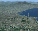
Campania, Italy, Photoreal Scenery Part 2 Naples (Napoli).
The photoreal scenery covers a great area of Campania around the city of Naples (Napoli). The airports of Napoli (ICAO code LINR) and Pontecagnano (LIRI) are founds inside the scenery (see map). For the best results, use it in association with other parts of Campania photoreal: Campania 1 Caserta, Campania 3 San Severo, Campania 4 Benevento, Campania 5 Melfi, Campania 6 Palinuro.
| Filename: | Italy_Campania_2_Naples_Napoli_Photo_Real.zip |
| License: | Freeware |
| Added: | 31st May 2010, 17:41:08 |
| Downloads: | 9,683 |
| Author: | Fulvio Mazzokan |
| Size: | 75.74 MB |
| Category: Flight Simulator 2004 - AI Flight Plans | |
| Nature Air (Costa Rica) Wi05 Flightplans (MRAI Installer Compatible) |
|
File Description:
MRAI Installer compatible flightplans for Nature Air for the Winter Season 2005. Nature Air operates their Islanders and Twin Otters from their base in San Jose, Costa Rica. They use MRPV, the Tobias Bolaños airport, which is actually in the town of Pavas, instead of the San Jose international airport (Juan Santamaria, MROC). These plans are 95% accurate from Nature Air's timetable valid 12/1/05 to 4/20/06.
| Filename: | Nature_Air_Costa_Rica_Wi05_Flightplans_MRAI_Instal.zip |
| License: | Freeware |
| Added: | 3rd January 2006, 03:19:53 |
| Downloads: | 915 |
| Author: | Denny Payne |
| Size: | 6.7 KB |
| Category: Flight Simulator 2004 - Scenery | |
| UTOD Khorog Airport, Tajikistan |
|
File Description:
Khorog Airport (UTOD), Tajikistan.
Khorog Airport serves the city of Khorugh, (a city in the Gorno-Badakhshan Autonomous Province in Tajikistan). Due to difficult weather conditions, flights are cancelled frequently.
The airport resides at an elevation of 6,700 feet (2,042 m) above mean sea level. It has one runway designated 16/34 with an asphalt surface measuring 1,840 by 49 metres (6,037 ft × 161 ft).[1]
| Filename: | UTOD_Khorog_Airport_Tajikistan.zip |
| License: | Freeware |
| Added: | 25th April 2013, 21:12:40 |
| Downloads: | 409 |
| Author: | Billy Guo |
| Size: | 191.54 KB |
| Category: Flight Simulator 2004 - Scenery | |
| Italy, Toscana 6, Firenze, Photo Real |
|
Images related to this file:
File Description:
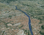
Toscana, Italy, Photoreal Scenery Part 6 (Firenze).
The photoreal scenery covers a great area of Toscana (Tuscany) around the city of Firenze (Florence). The airport of Firenze Peretola (LIRQ) are found inside the scenery (see map). For the best results, use it in association with other parts of Toscana photoreal: Toscana 1 Grosseto, Toscana 2 Piombino, Toscana 3 Siena, Toscana 4 Poggibonsi, Toscana 5 Livorno_Lucca_Pisa_Pistoia, Toscana 7 Massa_Carrara, italy_islands_vfr_part2_nw.zip
| Filename: | Italy_Toscana_6_Firenze_Photo_Real.zip |
| License: | Freeware |
| Added: | 28th April 2010, 13:46:09 |
| Downloads: | 7,054 |
| Author: | Fulvio Mazzokan |
| Size: | 89.82 MB |
| Category: Flight Simulator X - Scenery | |
| Victoria, Canada including US Southern Gulf Islands and San Juan Islands - Part 1 of 2 |
|
Images related to this file:
File Description:
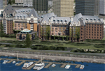
FSX-only version of Victoria, Canada area scenery including the Southern Gulf Islands and the San Juan Islands of the US. Includes automated installer and configurator by Scot Fraser.
Features:
-accurate shorelines, lakes and streams;
-landclass;
-FSX multi-LOD mesh with 10m maximum resolution;
-complete road network with moving traffic;
-railroads;
-utility corridors;
-marinas and ferry terminals;
-many static boats, including a custom model of the Canada Coast Guard ship Sir Wilfred Laurier;
-detailed models of major buildings and the Ogden Point Terminal;
-many bridges;
-nearly 300 marine lights; and corrected antennae locations.
Facilities include Don Grovestine's famous CYYJ (Victoria International Airport); 12 other Canadian land-based airports: Butler Field, Duncan (CAM3), Gaines, Hastings, Hudson Island, James Island, Thomas, Village Bay, Raven Field (CML2), Saltspring, Sidney Island, Whiskey Point; 20 US airports Blakely (38WA), Burden (61WA), Center Island (79WA), Clam Harbor (WA35), Crane Island, Decatur Shores (WN07), Decatur-Jones (WA18), Waldronaire (90WA), Orcas Island (KORS), Friday Harbour (KFHR), Lopez Island (S31), Pile Point, Roche Harbor (WA09), Shaw Island, Stuart Island Airpark (7WA5), Stuart Island West (2WA3), Wilding (6WA5), Windsock (4WA4); 12 floatplane facilities: Bedwell (CAB3), Fisherman's Bay (WA81), Friday Harbor (W33), Ganges (CAX6), Maple Bay, Mayne (CAW7), Port Washington (CAP8), Roche Harbor (W39), Rosario (W49), Shawnigan Lake (CAV8), Victoria Harbour (CYWH), Victoria International (CAP5) and Westsound, Orcas (WA83) - many with AI traffic; 9 heliports: Ganges (CAL7), Mayne (CBF5), Camel Point (CBF7), Jubilee (CBK8), Victoria General (CBW7) Madrona Bay (CBW9), Shoal Point (CBZ7), Mount Belcher (CMBH).
AI models include the DHC-2 floatplane in local liveries, a cruise ship model (by Mitsuya Hamaguchi) and two repaints, pilot boat, and small boats (by Larry Silsbee).
Ultimate Terrain X compatible (not required). Users of Vancouver+ for FSX will also get additional cruise ship traffic and additional floatplane and helicopter traffic. Full documentation. By Don Grovestine, Jon Patch and Holger Sandmann. Many other contributors: see documentation. Part 1 of 2 - you also need file vicenh7b.zip
| Filename: | Victoria_Canada_including_US_Southern_Gulf_Islands.zip |
| License: | Check within download |
| Added: | 29th January 2010, 21:23:17 |
| Downloads: | 23,161 |
| Author: | Don Grovestine, Jon Patch and Holger Sandmann |
| Size: | 56.8 MB |
| Category: Prepar3D V1-4 - Scenery | |
| Bahamas Scenery Pack 3-1: N & W Bahamas, Turks and Caicos + Eleuthera and Cat Island |
|
File Description:
This release replaces/updates Bahamas Scenery Pack 2-3. It includes everything in 2-3 (i.e., N and E Bahamas and Turks and Caicos) plus the first part of the Eastern Bahamas: Eleuthera and Cat Island! Other improvements include: * Added road traffic to all areas of the Bahamas * Improved coastlines around Grand Bahama and Bimini island.* Updated land class maps to improve appearance with Orbx Global Base scenery.
| Filename: | Bahamas_Scenery_Pack_31_N__W_Bahamas_Turks_and_Cai.zip |
| License: | Freeware |
| Added: | 1st June 2020, 18:49:14 |
| Downloads: | 2,021 |
| Author: | Gregory Goodwin |
| Size: | 25.65 MB |


© 2001-2026 AVSIM Online
All Rights Reserved
Privacy Policy |