
Where Flight Simulation Enthusiasts Gather from Around the World!
AVSIM Library - Search Results

| Category: Navigation and ATC - Navigation | |
| Lake Huron Sectional Chart Chunks for Aerosoft's FSMap |

|
File Description:
Sectional chart chunks made from the August 2009 Sectional charts at the original scale, formatted in the WGS84 lat/long geographic coordinate system for the FSMap, moving map application for flight simulation use. The chart chunks are the full sectional divided by 2 tiles (east/west) and converted to baseline 8bit tiffs with packbits compression applied. The images average 6,000x6,000 pixels at about 25mb each, also included is the FSMap fsm Calibration file for importing.
| Filename: | Lake_Huron_Sectional_Chart_Chunks_for_Aerosofts_FS.zip |
| License: | Freeware |
| Added: | 22nd March 2010, 20:40:41 |
| Downloads: | 337 |
| Author: | David Myers |
| Size: | 32.26 MB |
| Category: Navigation and ATC - Navigation | |
| Detroit Sectional Chart Chunks for Aerosoft's FSMap |
|
File Description:
Sectional chart chunks made from the August 2009 Sectional charts at the original scale, formatted in the WGS84 lat/long geographic coordinate system for the FSMap, moving map application for flight simulation use. The chart chunks are the full sectional divided by 2 tiles (east/west) and converted to baseline 8bit tiffs with packbits compression applied. The images average 6,000x6,000 pixels at about 25mb each, also included is the FSMap fsm Calibration file for importing.
| Filename: | Detroit_Sectional_Chart_Chunks_for_Aerosofts_FSMap.zip |
| License: | Freeware |
| Added: | 22nd March 2010, 20:40:50 |
| Downloads: | 390 |
| Author: | David Myers |
| Size: | 33.56 MB |
| Category: Navigation and ATC - Navigation | |
| Montreal Sectional Chart Chunks for Aerosoft's FSMap |
|
File Description:
Sectional chart chunks made from the August 2009 Sectional charts at the original scale, formatted in the WGS84 lat/long geographic coordinate system for the FSMap, moving map application for flight simulation use. The chart chunks are the full sectional divided by 2 tiles (east/west) and converted to baseline 8bit tiffs with packbits compression applied. The images average 6,000x6,000 pixels at about 25mb each, also included is the FSMap fsm Calibration file for importing.
| Filename: | Montreal_Sectional_Chart_Chunks_for_Aerosofts_FSMa.zip |
| License: | Freeware |
| Added: | 22nd March 2010, 20:40:58 |
| Downloads: | 436 |
| Author: | David Myers |
| Size: | 35.53 MB |
| Category: Navigation and ATC - Navigation | |
| New York Sectional Chart Chunks for Aerosoft's FSMap |
|
File Description:
Sectional chart chunks made from the August 2009 Sectional charts at the original scale, formatted in the WGS84 lat/long geographic coordinate system for the FSMap, moving map application for flight simulation use. The chart chunks are the full sectional divided by 2 tiles (east/west) and converted to baseline 8bit tiffs with packbits compression applied. The images average 6,000x6,000 pixels at about 25mb each, also included is the FSMap fsm Calibration file for importing.
| Filename: | New_York_Sectional_Chart_Chunks_for_Aerosofts_FSMa.zip |
| License: | Freeware |
| Added: | 22nd March 2010, 20:56:39 |
| Downloads: | 528 |
| Author: | David Myers |
| Size: | 34.43 MB |
| Category: Navigation and ATC - Navigation | |
| Halifax Sectional Chart Chunks for Aerosoft's FSMap |
|
File Description:
Sectional chart chunks made from the August 2009 Sectional charts at the original scale, formatted in the WGS84 lat/long geographic coordinate system for the FSMap, moving map application for flight simulation use. The chart chunks are the full sectional divided by 2 tiles (east/west) and converted to baseline 8bit tiffs with packbits compression applied. The images average 6,000x6,000 pixels at about 25mb each, also included is the FSMap fsm Calibration file for importing.
| Filename: | Halifax_Sectional_Chart_Chunks_for_Aerosofts_FSMap.zip |
| License: | Freeware |
| Added: | 22nd March 2010, 22:27:02 |
| Downloads: | 362 |
| Author: | David Myers |
| Size: | 29.08 MB |
| Category: Flight Simulator 2004 - Sounds | |
| Boeing 707 |
|
Images related to this file:
File Description:
This sound folder will give the Captain Sim Legendary 707 the more accurate fan whine sound that is characteristic of the JT3D turbo fan engine. It was developed for the original Legendary 707 for FS 2004, and may work in the Captain Sim latest release of the 707 for FSX. I'm not using FSX for various reasons, but if the new 707 has the same sound names found in this one, it should work.
| Filename: | Boeing_707.zip |
| License: | Freeware |
| Added: | 26th February 2011, 00:48:30 |
| Downloads: | 1,642 |
| Author: | Bill Melichar |
| Size: | 7.49 MB |
| Category: Flight Simulator X - Aircraft Repaints, Textures and Modifications | |
| World Airways Boeing 747-400BDSF v3 (N741WA) |
|
Images related to this file:
File Description:
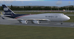
This FSX repaint depicts the second addition of the World Airways -400BDSF freighter fleet of N741WA, a converted freighter from Bedek.
The aircraft was hand painted using the PMDG paintkit and features DDS DXT5 textures including updated night illumination and custom cockpit view. This update fixes the flag reversal on the starboard side and updates the nose texture.
PMDG 747-400X for FSX required. See readme for important installation instructions and enjoy the repaint.
| Filename: | World_Airways_Boeing_747400BDSF_v3_N741WA.zip |
| License: | Freeware |
| Added: | 20th May 2011, 21:58:13 |
| Downloads: | 158 |
| Author: | Mark Aldridge |
| Size: | 902.78 KB |
| Category: Flight Simulator X - Scenery | |
| TUPW |
|
File Description:
Virgin Gorda Airport (IATA: VIJ, ICAO: TUPW) is an airport on Virgin Gorda in the British Virgin Islands, an overseas territory of the United Kingdom. The airport is owned and operated by the Government of the VI (UK). The government purchased the airport from Little Dix Bay Resort for $2.9 million in 2005. In January, 2010 the airport was closed for major construction work, it hopes to re-open in November, 2010.
| Filename: | TUPW.zip |
| License: | Freeware |
| Added: | 24th May 2011, 23:18:47 |
| Downloads: | 1,073 |
| Author: | Anwar Gonzalez |
| Size: | 2.86 KB |
| Category: Flight Simulator 2004 - Aircraft Repaints, Textures and Modifications | |
| AT-11 KANSAN Replacement DXT3 No MIP MAPS |
|
Images related to this file:
File Description:

AT-11 KANSAN DXT3 Texture Set WITH NO MIP MAPS Uploaded by Milton Shupe
These 10 folders replace the original 5 distributed folders with the AT-11 package, and the 5 extra International texture sets available by Damian Radice.
The aircraft.cfg distributed in the original download or the AT-11 was setup for all 10 sets.
The folders in this set each are 44MB smaller than the original folders for a savings of 440MB.
| Filename: | AT11_KANSAN_Replacement_DXT3_No_MIP_MAPS.zip |
| License: | Freeware |
| Added: | 23rd January 2011, 20:46:02 |
| Downloads: | 435 |
| Author: | Milton Shupe, Damian Radice |
| Size: | 20.93 MB |
| Category: Orbiter - Miscellaneous Files | |
| Valles Marineris Scenery |
|
File Description:
The Valles Marineris is a system of canyons located just south of the Martian equator. The system is about 4000 km long, and, if on earth, would extend all the way across the United States. The central individual troughs, generally 50 to 100 km wide, merge into a depression as much as 600 km wide. In places the canyon floor reaches a depth of 10 km, 6 to 7 times deeper than the Grand Canyon.
| Filename: | Valles_Marineris_Scenery.zip |
| License: | Freeware |
| Added: | 5th November 2002, 13:07:38 |
| Downloads: | 1,672 |
| Author: | Robert Stettner (Foxtrot) |
| Size: | 1.52 MB |


© 2001-2026 AVSIM Online
All Rights Reserved
Privacy Policy |