
Where Flight Simulation Enthusiasts Gather from Around the World!
AVSIM Library - Search Results

| Category: Flight Simulator 2004 - Scenery | |
| PAMR - Merrill Field - Anchorage, Alaska - Texture Update |

|
Images related to this file:
File Description:
This texture for one of Sidney Schwarz's lights will prevent my Merrill Field scenery from generating blurred textures when you are flying nearby. It all depends on your settings within FS9 so you might never have had that problem, and if you haven't then you don't need this. If you have had that problem, and I did, then you really need this. Sid issued new textures some while ago, but unfortunately it wasn't known that his light was causing the problem until this week, and I never downloaded the new ones. I have also taken this opportunity to provide new AI with minor adjustment to levels for both Merrill and Lake Hood. These go into Scenery/World/Scenery and say yes to over-write.
| Filename: | merrill_field_update_2014.zip |
| License: | Freeware, limited distribution |
| Added: | 9th May 2014, 19:44:48 |
| Downloads: | 291 |
| Author: | Roger Wensley |
| Size: | 142 KB |
| Category: Flight Simulator 2004 - Scenery | |
| Fairbanks PAFA / FAI Version 3.0 |
|
Images related to this file:
File Description:

This is a coplete rebuild of Fairbanks Int'l Airport. The passenger
terminals have been replaced with custom buildings, and the general aviation side of the field is buzzing
with life. Many static aircraft pepper the parking area and hangars are placed throughout. The AFCAD file
was built from the default version with AFX. This scenery was built using Flight1's Instant Scenery program.
Update:
This version contains the brand new passenger terminal as designed and built by Sidney Scwartz. The entire airport is rebuilt from scratch
along with an all new afcad featuring new ground texturing. The West side of the airport has also been remade to be much more accurate.
There is also an active water runway in use.
| Filename: | pafav3.zip |
| License: | Freeware |
| Added: | 18th August 2013, 18:37:22 |
| Downloads: | 2,793 |
| Author: | FRFStudio.net / William Morgan |
| Size: | 18.78 MB |
| Category: Flight Simulator X - Scenery | |
| Monroe County Airport - KBMG - Bloomington, Indiana |
|
Images related to this file:
File Description:
This scenery replaces the FSX default airport and brings the Monroe County Airport - KBMG in Bloomington, Indiana, USA, up to date with it's current Airport Diagram with added buildings, taxiways, and as much true-life character as I could find in available 3rd party freeware scenery object libraries. This scenery was specifically created to overcome the issue of appearing/disappearing buildings and scenery objects when using on top of photoreal scenery, such as Megascenery Earth Indiana V2 & V3 sceneries. This scenery does require that you have two addon scenery libraries installed and activated. Refer to the readme.txt file for more information.
"ga_hangers_ss_v3.zip" Sidney Schwartz's GA Hangers V3, available in Avsim's Flight Simulator 2004 - Scenery Design section.
"mao_js.zip" John Stinstrom's FS2004 Military Cargo Objects, available as: In Avsim's Flight Simulator 2004 - Scenery section
| Filename: | kbmg_fjpv1.zip |
| License: | Freeware |
| Added: | 8th May 2018, 04:13:12 |
| Downloads: | 506 |
| Author: | Frank Patton |
| Size: | 3.01 MB |
| Category: Flight Simulator 2004 - Scenery | |
| Toronto Downtown Airport CYTZ Ontario, Canada |
|
Images related to this file:
File Description:
CYTZ is on an island in Lake Ontario and immediately adjacent to downtown Toronto. This updates the version made by Flight Ontario as there have been major changes since Porter Airlines purchased the airport. The obvious and main new item is the terminal, made with photo textures and with ten gates sized to accomodate the Dash 8-400 they currently use. The terminal has a passenger entrance and a vehicle setdown point as part of the link to the ferry terminal that wraps around the west side of the original and preserved terminal building. The ferry terminal is included here, along with a ferry. Also new are the car parking, road routing, gate and taxi markings, taxiways, taxiway signage, taxiway lighting, runway lighting, aprons, apron lighting (from Sid Schwartz and you will need to install his "lights_ss_v2"), fences, fuel tanks, tanker trucks, access roads to navigation equipment, ai parking, static parked planes, parked cars, apron equipment, and the useable floatplane ramp. The AI includes Porter, Jazz, several GA aircraft, and a helicopter. Only 3 of these require downloads. The Lake Ontario AI includes three large ships, typical of the traffic to be seen on all the Great Lakes. CYTZ has three runways and there is an airport diagram included. 08-26 has ILS and is the only runway actually long enough to be used by Porter; FS9 atc will ignore this. There is fuel available and it is dispensed from a truck. The longer projection from the front of the terminal building is a covered ramp that leads up from the terminal basement level, used by towed luggage trolleys. The gates are not powered in any way except for the weather cover that protects passengers as they cross the small area of asphalt between plane and gate. I did not try to reproduce this in FS9.
| Filename: | toronto_downtown_cytz.zip |
| License: | Freeware, limited distribution |
| Added: | 23rd October 2012, 12:52:14 |
| Downloads: | 1,773 |
| Author: | Roger Wensley + Flight Ontario |
| Size: | 12.96 MB |
| Category: Prepar3D V1-4 - Aircraft Repaints, Textures and Modifications | |
| Alaska Airlines "HONORING THOSE WHO SERVE" livery Operated by Horizon Air E175LR (N651QX) |
|
Images related to this file:
File Description:
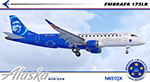
I am proud to present this very special Alaska Airlines Embraer E175LR, operated by Horizon Air, registration N651QX. This E175LR is the third "Honoring Those Who Serve" aircraft in the Alaska Airlines fleet which pays tribute to US military members, veterans, fallen soldiers and their families. Its unique exterior paint scheme, conceived by a small group of Alaska maintenance technicians, was designed to honor those who serve today, and those who served in the past. The design includes; A red stripe and blue aircraft body to incorporate elements of the American flag, the phrase "Honoring Those Who Serve," displayed on the fuselage, symbolic crests representing the Alaska Airlines Fallen Soldier Program on the starboard side rear cargo door and on the port side of the aircraft behind the aft service door, a "Horizon Air Salutes" medallion near the nose of the aircraft on both sides with the five stars, winglets in red, white and blue representing the flag of the United States and five gold stripes on the engine cowls representing the five branches of the U.S. Armed Forces. There is also a Sidney Sheldon quote next to the forward passenger entry door reading “My heroes are those that risk their lives to protect the world and make it a better place.â€
The repainted textures in this package are 32-bit with no mipmaps for best clarity and quality. All of the medallions are hand painted. This is the Version 3 model of the FeelThere Embraer 175. You must own a copy of the Feelthere E-JETS E175 and E195 V3 to enjoy this repaint.
A special thank you to all who serve, who have served and to those who gave their lives in service to this country.
| Filename: | ft_e175_v3_asa_n651qx.zip |
| License: | Freeware, limited distribution |
| Added: | 29th April 2020, 19:09:32 |
| Downloads: | 824 |
| Author: | Jeffrey S. Bryner, FeelThere |
| Size: | 56.71 MB |
| Category: Flight Simulator X - Scenery | |
| Victoria, Canada including US Southern Gulf Islands and San Juan Islands - Part 1 of 2 |
|
Images related to this file:
File Description:
FSX-only version of Victoria, Canada area scenery including the Southern Gulf Islands and the San Juan Islands of the US. Includes automated installer and configurator by Scot Fraser.
Features:
-accurate shorelines, lakes and streams;
-landclass;
-FSX multi-LOD mesh with 10m maximum resolution;
-complete road network with moving traffic;
-railroads;
-utility corridors;
-marinas and ferry terminals;
-many static boats, including a custom model of the Canada Coast Guard ship Sir Wilfred Laurier;
-detailed models of major buildings and the Ogden Point Terminal;
-many bridges;
-nearly 300 marine lights; and corrected antennae locations.
Facilities include Don Grovestine's famous CYYJ (Victoria International Airport); 12 other Canadian land-based airports: Butler Field, Duncan (CAM3), Gaines, Hastings, Hudson Island, James Island, Thomas, Village Bay, Raven Field (CML2), Saltspring, Sidney Island, Whiskey Point; 20 US airports Blakely (38WA), Burden (61WA), Center Island (79WA), Clam Harbor (WA35), Crane Island, Decatur Shores (WN07), Decatur-Jones (WA18), Waldronaire (90WA), Orcas Island (KORS), Friday Harbour (KFHR), Lopez Island (S31), Pile Point, Roche Harbor (WA09), Shaw Island, Stuart Island Airpark (7WA5), Stuart Island West (2WA3), Wilding (6WA5), Windsock (4WA4); 12 floatplane facilities: Bedwell (CAB3), Fisherman's Bay (WA81), Friday Harbor (W33), Ganges (CAX6), Maple Bay, Mayne (CAW7), Port Washington (CAP8), Roche Harbor (W39), Rosario (W49), Shawnigan Lake (CAV8), Victoria Harbour (CYWH), Victoria International (CAP5) and Westsound, Orcas (WA83) - many with AI traffic; 9 heliports: Ganges (CAL7), Mayne (CBF5), Camel Point (CBF7), Jubilee (CBK8), Victoria General (CBW7) Madrona Bay (CBW9), Shoal Point (CBZ7), Mount Belcher (CMBH).
AI models include the DHC-2 floatplane in local liveries, a cruise ship model (by Mitsuya Hamaguchi) and two repaints, pilot boat, and small boats (by Larry Silsbee).
Ultimate Terrain X compatible (not required). Users of Vancouver+ for FSX will also get additional cruise ship traffic and additional floatplane and helicopter traffic. Full documentation. By Don Grovestine, Jon Patch and Holger Sandmann. Many other contributors: see documentation. Part 1 of 2 - you also need file vicenh7b.zip
| Filename: | vicenh7a.zip |
| License: | Check within download |
| Added: | 29th January 2010, 21:23:17 |
| Downloads: | 23,107 |
| Author: | Don Grovestine, Jon Patch and Holger Sandmann |
| Size: | 56.8 MB |
| Category: Flight Simulator X - Scenery | |
| Victoria, Canada including US Southern Gulf Islands and San Juan Islands - Part 2 of 2 |
|
Images related to this file:
File Description:

FSX-only version of Victoria, Canada area scenery including the Southern Gulf Islands and the San Juan Islands of the US. Includes automated installer and configurator by Scot Fraser.
Features:
-accurate shorelines, lakes and streams;
-landclass;
-FSX multi-LOD mesh with 10m maximum resolution;
-complete road network with moving traffic;
-railroads;
-utility corridors;
-marinas and ferry terminals;
-many static boats, including a custom model of the Canada Coast Guard ship Sir Wilfred Laurier;
-detailed models of major buildings and the Ogden Point Terminal;
-many bridges;
-nearly 300 marine lights; and corrected antennae locations.
Facilities include Don Grovestine's famous CYYJ (Victoria International Airport); 12 other Canadian land-based airports: Butler Field, Duncan (CAM3), Gaines, Hastings, Hudson Island, James Island, Thomas, Village Bay, Raven Field (CML2), Saltspring, Sidney Island, Whiskey Point; 20 US airports Blakely (38WA), Burden (61WA), Center Island (79WA), Clam Harbor (WA35), Crane Island, Decatur Shores (WN07), Decatur-Jones (WA18), Waldronaire (90WA), Orcas Island (KORS), Friday Harbour (KFHR), Lopez Island (S31), Pile Point, Roche Harbor (WA09), Shaw Island, Stuart Island Airpark (7WA5), Stuart Island West (2WA3), Wilding (6WA5), Windsock (4WA4); 12 floatplane facilities: Bedwell (CAB3), Fisherman's Bay (WA81), Friday Harbor (W33), Ganges (CAX6), Maple Bay, Mayne (CAW7), Port Washington (CAP8), Roche Harbor (W39), Rosario (W49), Shawnigan Lake (CAV8), Victoria Harbour (CYWH), Victoria International (CAP5) and Westsound, Orcas (WA83) - many with AI traffic; 9 heliports: Ganges (CAL7), Mayne (CBF5), Camel Point (CBF7), Jubilee (CBK8), Victoria General (CBW7) Madrona Bay (CBW9), Shoal Point (CBZ7), Mount Belcher (CMBH).
AI models include the DHC-2 floatplane in local liveries, a cruise ship model (by Mitsuya Hamaguchi) and two repaints, pilot boat, and small boats (by Larry Silsbee).
Ultimate Terrain X compatible (not required). Users of Vancouver+ for FSX will also get additional cruise ship traffic and additional floatplane and helicopter traffic. Full documentation. By Don Grovestine, Jon Patch and Holger Sandmann. Many other contributors: see documentation. Part 2 of 2 - you also need file vicenh7a.zip
| Filename: | vicenh7b.zip |
| License: | Check within download |
| Added: | 29th January 2010, 21:21:49 |
| Downloads: | 23,107 |
| Author: | Don Grovestine, Jon Patch and Holger Sandmann |
| Size: | 59.08 MB |
| Category: Flight Simulator X - Scenery | |
| Merrill Field PAMR |
|
Images related to this file:
File Description:
This is a version for FSX of the Merrill Field made by Roger Wensley (me) for FS9, converted by John B Loney jnr. "PAMR read this first" explains this but I have modified John's original procedure, and instead of first installing the Merrill Field original plus two updates I have included here the current FS9 version as installed on my computer. Note that to see the apron lighting working in FS9 it was necessary to have Sidney Schwartz's light library installed, along with his updated textures (to avoid severe blurries caused by a faulty texture). The original installation instructions are included giving file library priorities etc. Just ignore the bits that do not apply, such as installing AI that is not included. I have of course omitted the original AI as this is replaced by John's version. I have no comment to make on installing in FSX as I have not done so, and I have not tested it in FSX. If you have comments or questions I will respond as much as I am able. Merrill Field is in Anchorage Alaska, between Anchorage International to the southwest and and Elmendorf Air Force Base to the north. It caters for general aviation and is the land equivalent of the Lake Hood float plane base, with fuel and numerous maintenance facilities, and several hundred parking spots for small planes. There are three runways, and the longest is 4,000 feet of 100 feet wide asphalt, the second 2,635 feet of asphalt 75 feet wide, and the third 2,000 feet of 60 feet wide gravel. The first two have runway lights. It is a controlled airfield with a relatively new control tower to cater for the numerous flights and to coordinate with Elmensdorf and Anchorage International, the latter also controlling flights from Lake Hood and the adjacent gravel strip Z41. (See my Lake Hood scenery). The gravel runway at Merrill Field is not connected with active taxiways to the rest of the airfield; this avoids you being ordered to land on it when flying a plane too large to do so.
| Filename: | merrill_field_pamr_for_fsx.zip |
| License: | Freeware, limited distribution |
| Added: | 3rd July 2017, 18:00:19 |
| Downloads: | 431 |
| Author: | Roger Wensley and John B loney jnr |
| Size: | 22.49 MB |
© 2001-2025 AVSIM Online
All Rights Reserved