
Where Flight Simulation Enthusiasts Gather from Around the World!
AVSIM Library - Search Results

| Category: Flight Simulator X - Scenery | |
| VYYY Yangon Intl Airport Mingaladon V3.0 |

|
File Description:
Yangon International Airport "MINGALADON" in Burma, Myanmar, will be able to accommodate bigger aircrafts and handle more passengers when work on extending its runway and upgrading its facilities is completed. The completion of the runway extension will enable Boeing 747 and Airbus 380 airplanes to use the airport. The work on extending the runway from 8100 feet to 11,200 feet began October 2004. FPS-friendly version 3.0 with already extended runway, taxiways and new taxisigns. First of all we corrected the airport location to the real one. With Myanmar Air Force area, Helipads and even more parkings for civilian airplanes. This scenery was produced based on pictures of satellites. Many Thanks go to the teams of HOUSE-RP in Burma, FSX Planner, SceneGenX, SBuilder X, Open Ports Scanner, AFXBgDownloader, FSUIPC and Google Earth. This scenery is only for FSX, for FS2004 please download vyyy_v2.zip. By HOUSE-RP, Switzerland and Burma
| Filename: | VYYY_Yangon_Intl_Airport_Mingaladon_V30.zip |
| License: | Freeware, limited distribution |
| Added: | 28th October 2007, 19:21:14 |
| Downloads: | 1,228 |
| Author: | HOUSE-RP, Robby Pauletto |
| Size: | 18.29 KB |
| Category: Flight Simulator 2004 - Scenery | |
| Petaluma , California (O69) Scenery |
|
File Description:
This is a scenery upgrade for Petaluma Airport, California (O69). This is part Five of a series of small airstrip and minor airfield scenery enhancements which are based on real world data from Google Earth.
This is a more complex scenery than previous ones. You can see from the Google earth image that a golf course runs alongside the airport (appropriately called the Rabbit Run!). I have tried to include this with a golf course landclass polygon, also the airfield base seems mainly a red soil and this is reflected in the airbase poly. Built using EZ_Scenery, Lee Swordy's AFCAD and SBuilder. You must have rwy12 and EZ scenery libraries installed for the buildings to show. Both libraries of objects are free;
EZ Library is available from this URL http://www.abacuspub.com/pub/AbacusEZLibraries.exe
rwy12 from Avsim and additional EZ Custom libraries from Avsim. Search under Scenery design.
| Filename: | Petaluma__California_O69_Scenery.zip |
| License: | Freeware |
| Added: | 23rd March 2006, 23:09:07 |
| Downloads: | 719 |
| Author: | Kim Gowney |
| Size: | 629.87 KB |
| Category: Flight Simulator 2004 - Scenery | |
| Branson Airport KBBG--New Airport, Scenery, and Flight Plans |
|
Images related to this file:
File Description:

This project adds a new Branson Airport KBBG (Missouri) to FS 2004, which opened in May 2009, and is a privately developed commercial airport. The construction of the airport, which involved the flattening of several Ozark Mountains, is claimed to be the largest earthmoving project in Missouri history. As a result, the airport actually sits on a manmade plateau, surrounded by rolling hills. The airport uses the ICAO identifier BBG, however, the airlines use the IATA code BKG. The airport is served by AirTran, Frontier, and ExpressJet (Branson AirExpress), and is located in hilly terrain. Aircraft equipped with a terrain avoidance warning system may experience system activation on final approach. AFCAD created using Airport Design Editor 9 v1.47.07, and the hilltops were cleared and flattened and roads were added using SBuilder 2.05 revision 06. The terminal and hangar were added and modified from within Airport Design Editor 9. This airport is based on my more detailed FSX version, Branson_Airport_Project.zip.
| Filename: | Branson_Airport_KBBGNew_Airport_Scenery_and_Flight.zip |
| License: | Freeware |
| Added: | 16th August 2010, 20:50:16 |
| Downloads: | 1,731 |
| Author: | Carlyle Sharpe |
| Size: | 3.23 MB |
| Category: Flight Simulator 2004 - Scenery | |
| Funny Farm (4CA2) Brentwood, California Scenery |
|
File Description:
This is a scenery upgrade for Funny Farm Airport, Brentwood, California (4CA2) (Why Funny Farm?) This is part Nine of a series of small airstrip and minor airfield scenery enhancements which are based on real world data from Google Earth. The scenery mainly reflects the appearance of the airpark from directly above, so if you are familiar with the place then on the ground it probably looks quite different, due to the limited number of buildings available. This scenery includes the Private lake and dwellings to the southwest of the airstrip proper plus extensive landclass alterations to make the small paddocks in the same area. This is a tough place to land neatly in anything past a C172 in calm weather; the runway is only 20 feet wide! Built using EZ_Scenery, Lee Swordy's AFCAD and SBuilder. You must have rwy12 and EZ scenery libraries installed for the buildings to show. Both libraries of objects are free: EZ Library is available from http://www.abacuspub.com/pub/AbacusEZLibraries.exe and rwy12 and additional EZ Custom libraries from Avsim. Search under Scenery design.
| Filename: | Funny_Farm_4CA2_Brentwood_California_Scenery.zip |
| License: | Freeware |
| Added: | 1st April 2006, 23:42:42 |
| Downloads: | 547 |
| Author: | Kim Gowney |
| Size: | 359.43 KB |
| Category: Flight Simulator X - Scenery | |
| VYMM Mawlamyine Intl Airport V2.0 with Traffic-Pack 2 |
|
File Description:
Mawlamyine International Airport in Burma, Myanmar, include Traffic-Pack 2. Traffic-Pack 1 comes with vyyy4tp1.zip. Traffic-Pack 3 comes soon too. This scenery was produced based of suppositions, stories and voices. It is therefore pure speculation. Whether this airport is ever increased, the God know. If the planned Asean-Highway leads at it past, this airport should gain importance very quickly. Version 2.0 with new docks, jetways, already extended runway, taxiways and new taxisigns. First of all we corrected the airport location to the real one. With Myanmar Air Force area, Helipads and even more parkings for civilian airplanes. You need mai321x.zip, mai738x.zip and mai744x.zip to use with this. Many Thanks go to Harald Nehring and Frank Weiss,
Robert Versluys, Mike Stone and the teams of HOUSE-RP in Burma, FSX Planner, SceneGenX, SBuilder X, Open Ports Scanner, AFXBgDownloader, FSUIPC, Google Earth and AI Flight Planner. This scenery is pure fiction and for FSX only, for FS2004 please download newVYMMfs9.zip and newVYMMup.zip. By HOUSE-RP, Switzerland and Burma
| Filename: | VYMM_Mawlamyine_Intl_Airport_V20_with_TrafficPack_.zip |
| License: | Freeware, limited distribution |
| Added: | 6th June 2008, 15:34:08 |
| Downloads: | 672 |
| Author: | HOUSE-RP, Robby Pauletto |
| Size: | 3.42 MB |
| Category: Flight Simulator 2004 - Scenery | |
| FHSH - St. Helena Island & Airport - St. Helena, South Atlantic |
|
Images related to this file:
File Description:
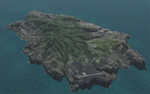
This project is a port of my FSX release of the the new airport (FHSH) on St. Helena Island. This scenery provides more accurate coastlines and roads, as well as corrected landclass based on the latest available satellite imagery. Flight plans are provided for the proposed commercial service to St. Helena, and some additional GA and military flights to the island are added as well.
The FS2004 St. Helena (FHSH) airport was created by aligning master plans for the airport with current satellite data and by studying many of the pictures that have been posted as the airport has taken shape. The official opening of the real airport on May 21, 2016, has been pushed back for more field tests due to challenging crosswinds. Updates were created or rebuilt in a manner which carefully aligns airport data with current satellite imagery. Scenery was created using Airport Design Editor 9 v1.67.5684 and SBuilder. Scenery objects were added and modified from stock FS9 scenery to resemble as closely as possible the actual airports.
| Filename: | FHSH__St_Helena_Island__Airport__St_Helena_South_A.zip |
| License: | Freeware |
| Added: | 5th May 2016, 07:44:38 |
| Downloads: | 2,229 |
| Author: | Carlyle Sharpe |
| Size: | 1.62 MB |
| Category: Flight Simulator 2004 - Scenery Design | |
| Default Terminal Buildings Subset V2 scenery objects |
|
Images related to this file:
File Description:
[Version 2 adds specific compatibility with RWY12, ADE9X, and Sbuilder 2.05. If you have already installed the previous version of this library and are NOT using one of these programs to place scenery objects, you do not need to download and install V2.] Many scenery making programs for FS9 give us access to the default terminal buildings in the FS9 libraries. Unfortunately the FS9 libraries are completely unorganized, so finding a specific shape and color of building can be time consuming. Also, many of the terminal buildings are too distinctive in appearance to be of much use to someone who is looking for simple shapes to use as "building blocks" to create their own terminals. I went through most of the FS9 scenery libraries that contain terminal buildings and chose a representative sampling of simple shapes in the various textures that are available, and compiled these into a scenery object library. This makes it easier to find, say, a two story, T-shaped, yellow textured terminal building. These are not new objects, they are default scenery objects created and owned by Microsoft. I'm simply providing a more convenient way to use them. Previous version had 9300(!) downloads.
| Filename: | Default_Terminal_Buildings_Subset_V2_scenery_objec.zip |
| License: | Freeware |
| Added: | 14th November 2009, 01:18:05 |
| Downloads: | 4,242 |
| Author: | Sidney Schwartz |
| Size: | 4.21 MB |
| Category: Flight Simulator 2004 - Scenery | |
| Monterey Academy CA66 California Scenery |
|
File Description:
This is a scenery upgrade for Monterey Academy Airstrip, California (CA66). This is part Seven of a
series of small airstrip and minor airfield scenery enhancements which are based on real world data
from Google Earth.
Changes to default include an AFCAD file that covers some of the buildings that seem to be
associated with the airstrip, Landclass change to reflect the fact that the strip lies in agricultural
ground rather that the scrubland the default has it in. Note that the buildings are used to appear
the same as they do from directly above rather than a genuine representation of what is probably
there. So from ground level it will look a lot different to the real thing should you be familiar with it!
This is due to the limited number of buildings available ATM.
Also My screenshots are using Flight1 Ground Environment textures, so your land may look different
if you have the default terrain.
Thanks to Jon "Scruffyduck" Masterson for tutorials on LC and scenery design.
Built using EZ_Scenery, Lee Swordy's AFCAD and SBuilder. You must have rwy12 and EZ scenery
libraries installed for the buildings to show, both libraries of objects are free
EZ Library is available from this URL http://www.abacuspub.com/pub/AbacusEZLibraries.exe
rwy12 from Avsim and additional EZ Custom libraries from Avsim also, search under Scenery design.
| Filename: | Monterey_Academy_CA66_California_Scenery.zip |
| License: | Freeware |
| Added: | 25th March 2006, 23:10:11 |
| Downloads: | 589 |
| Author: | Kim Gowney |
| Size: | 250.98 KB |
| Category: Flight Simulator 2004 - Scenery | |
| Prudhoe Bay area on Alaska North Slope US |
|
Images related to this file:
File Description:
The Prudhoe Bay area of the Alaska north slope is dominated by all the equipment and machinery that is necessary for the extraction of oil and its transfer by the pipeline that reaches south to Valdez. Prudhoe Bay airport is now closed, and its replacement just to the south is Deadhorse PASC, with numerous storage, maintenance, and accomodation areas immediately to the north of the apron, and others adjacent to the road between the two. The runway is just under 6,500 feet with approach lights at both ends and ILS on 04 (true heading of 75 degrees). This scenery reflects the overall situation in 2011 and oil production facilities and buildings are included here. The airport buildings and those close to the airport are replicas of the real life buildings; while as distance increases the accuracy fades somewhat there are everywhere replica trucks and cross country vehicles that are true to life. Deadhorse handles around 7,000 passengers per month as staff are rotated in and out on Alaska Air and ERA flights and by oil company private flights. There are also freight flights to complement the trucking effort up the Dalton Highway. The Alaska Airlines terminal building and ERA (the red buildings nearby) are at one end of the apron, while at the other end is a very large and new green terminal, storage, hangar building built by the airport authority. All of the airport components, runways, taxiways, and aprons, are built up on a gravel base to raise them above the surrounding terrain that floods with melting snow, freezes, or dries out, according to the seasons. There are other new airstrips included here that serve the oil industry. Around 33 miles to the east is Badami PABP airport servicing a subsiduary oil producing area, with 5,000 feet of gravel runway. Some 28 miles to the west of Deadhorse is Ugnu-Kuparuk UBW with just over 6,000 feet of gravel (gravel in 2011, it is now asphalted) servicing oil production by Conoco Phillips, which uses 737's to fly staff in and out. A further 32 miles west is Alpine AK15 with 5,400 feet of gravel and also served by the Conoco Phillips 737's. To the south of Alpine and connected by road is the village of Nuiqsut. To the north of Alpine and reachable only by air in the delta of the Sagavanirktok River is CD-3, an oil collection and pump station area with another gravel runway of 3,000 feet. Other airstrips that were prviously posted are now updated, Nuiqsut and Oliktok. I experimented, but decided against trying to reproduce the several hundred miles of pipelines. The are new AI aircraft, and there are notes regarding downloading. There is a new "cement" texture (not its name, but used as that by SBuilder) for the built up gravel bases. It is slightly darker than the original but not so much that any previous use will be spoilt. You may wish to download my "Alaska Frozen Rivers and Lakes" which freezes lakes and the northern sea and makes them landable on wheels.
| Filename: | Prudhoe_Bay_area_on_Alaska_North_Slope_US.zip |
| License: | Freeware, limited distribution |
| Added: | 19th December 2017, 00:38:06 |
| Downloads: | 583 |
| Author: | Roger Wensley |
| Size: | 28.54 MB |
© 2001-2026 AVSIM Online
All Rights Reserved
Privacy Policy |