
Where Flight Simulation Enthusiasts Gather from Around the World!
AVSIM Library - Search Results

| Category: Flight Simulator X - Scenery | |
| Mesh-South America MeSA_E10 |

|
File Description:
FSX Mesh South America Project:
This terrain mesh file is a part of a whole project covering all the Continent
of South America and some islands, divided in tiles identified in a map by its
column (letters) and rows (numbers).
Those files were multi-LOD compiled from 90m SRTM2 source data, reprocessed
with 3DEM to remove voids and spikes, providing a 76.4m (LOD9) horizontal
resolution topography intended for use only in FSX updated with SP1.
Although not well documented, to improve performance, the updated FSX loads DEM
files in threads and only the closer terrain (about 5-10 NM from the point of view)
is rendered in high detail, while at far distances FSX shows up its default low
resolution mesh, when there is not a third part terrain mesh compiled in all
others intermediate level of details (multi-LOD).
THIS FILE:
FSX_MeSA_E10 (Column E x Row 10)
covers the area inside the boundaries:
N = 33º 45' S; S = 39º 22,5' S;
W = 60º 0' W; E = 52º 30' W;
AUTHORS:
Hely Heck Junior - Magrao ( [email protected] )
and Jose Lobo ( [email protected] )
TerraBrasilis: www.terra-brasilis.org
| Filename: | MeshSouth_America_MeSA_E10.zip |
| License: | Freeware |
| Added: | 14th June 2007, 13:59:05 |
| Downloads: | 943 |
| Author: | Hely Heck Jr. and José Lôbo |
| Size: | 21.54 MB |
| Category: Flight Simulator X - Scenery | |
| Mesh-South America MeSA_F04 |
|
File Description:
FSX Mesh South America Project:
This terrain mesh file is a part of a whole project covering all the Continent
of South America and some islands, divided in tiles identified in a map by its
column (letters) and rows (numbers).
Those files were multi-LOD compiled from 90m SRTM2 source data, reprocessed
with 3DEM to remove voids and spikes, providing a 76.4m (LOD9) horizontal
resolution topography intended for use only in FSX updated with SP1.
Although not well documented, to improve performance, the updated FSX loads DEM
files in threads and only the closer terrain (about 5-10 NM from the point of view)
is rendered in high detail, while at far distances FSX shows up its default low
resolution mesh, when there is not a third part terrain mesh compiled in all
others intermediate level of details (multi-LOD).
THIS FILE:
FSX_MeSA_F04 (Column F x Row 04)
This file covers the area inside the boundaries:
N = 0º 0' S; S = 5º 37.5' S;
W = 52º 30' W; E = 45º 0' W;
AUTHORS:
Hely Heck Junior - Magrao ( [email protected] )
and Jose Lobo ( [email protected] )
TerraBrasilis: www.terra-brasilis.org
| Filename: | MeshSouth_America_MeSA_F04.zip |
| License: | Freeware |
| Added: | 14th June 2007, 14:01:32 |
| Downloads: | 973 |
| Author: | Hely Heck Jr. and José Lôbo |
| Size: | 68.63 MB |
| Category: Flight Simulator X - Scenery | |
| Mesh-South America MeSA_G04 |
|
File Description:
FSX Mesh South America Project:
This terrain mesh file is a part of a whole project covering all the Continent
of South America and some islands, divided in tiles identified in a map by its
column (letters) and rows (numbers).
Those files were multi-LOD compiled from 90m SRTM2 source data, reprocessed
with 3DEM to remove voids and spikes, providing a 76.4m (LOD9) horizontal
resolution topography intended for use only in FSX updated with SP1.
Although not well documented, to improve performance, the updated FSX loads DEM
files in threads and only the closer terrain (about 5-10 NM from the point of view)
is rendered in high detail, while at far distances FSX shows up its default low
resolution mesh, when there is not a third part terrain mesh compiled in all
others intermediate level of details (multi-LOD).
THIS FILE:
FSX_MeSA_G04 (Column G x Row 04)
covers the area inside the boundaries:
N = 0º 0' S; S = 5º 37.5' S;
W = 45º 0' W; E = 37º 30' W;
AUTHORS:
Hely Heck Junior - Magrao ( [email protected] )
and Jose Lobo ( [email protected] )
TerraBrasilis: www.terra-brasilis.org
| Filename: | MeshSouth_America_MeSA_G04.zip |
| License: | Freeware |
| Added: | 15th June 2007, 00:10:58 |
| Downloads: | 867 |
| Author: | Hely Heck Jr. and José Lôbo |
| Size: | 35.9 MB |
| Category: Flight Simulator 2004 - Aircraft Repaints, Textures and Modifications | |
| Airblue Airbus A319-112 |
|
File Description:
Virtual Airblue in association with Virtual PIA proudly presents the Project Airbus A319-112 in Airblue colours. Airblue is a Pakistan based LCC that operates throughout the Middle East and to Europe, besides domestic operations. The young airline has fast become the main competitor of national flag carrier PIA. This aircraft, previously operated by Skybus (USA) was acquired by Airblue after the former airline went bust, and has since been operating on a number of local and international routes. This aircraft wears the registration AP-BIF, and is equipped with slim recaro seats that provide maximum comfort and legroom for passengers. The repaint features accurately placed titles and photoreal tail texture adopted from a photograph. The registration appears on top of the right wing and the bottom of the left wing, and an airblue logo appears on the top of the left wing and the bottom of the right one. The Pakistani flag is placed next to the doors as well. Model features accurate dynamics plus 4 opening passenger doors and 2 cargo doors. Model by Project Airbus, repaint by Ahmed Ahsen exclusively from Virtual PIA(VPIA).
| Filename: | Airblue_Airbus_A319112.zip |
| License: | Freeware, limited distribution |
| Added: | 10th July 2010, 10:12:29 |
| Downloads: | 461 |
| Author: | Ahmed Ahsen (Virtual PIA/VPIA) |
| Size: | 6.32 MB |
| Category: Flight Simulator X - Scenery | |
| Goma Intl (FZNA) DRC and Gisenyi (HRYG) Rwanda |
|
Images related to this file:
File Description:
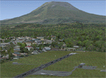
This project includes the neighboring Goma Intl (FZNA) and Gisenyi (HRYG) airports. After Goma's only runway was severely damaged by the eruption of Mount Nyiragongo in 2002, the runway, originally 3000m long, was reduced to 1800m of serviceable pavement after lava flowed onto the northern part runway and through the city center. In 2013, German NGO Welthungerhilfe ("World Hunger Aid") signed a contract to rehabilitate 500m of runway damaged by the lava flow. Goma resumed scheduled international flights in 2015, and this project reflects the airport as of March 2016, with runway 18/36 renumbered to 17/35. SRTMGL1 (30m) mesh brings the volcanoes in the area into much greater detail. This scenery is complimented by the Kigali Intl (HRYR) scenery (FSX_HRYR_Kigali_2016.zip).
Updates were created or rebuilt in a manner which carefully aligns airport data with current satellite imagery. Scenery was created using Airport Design Editor X v1.70.6042, SBuilderX 3.13, and the FSX Object Placement Tool. Scenery objects were added and modified from stock FSX scenery to resemble as closely as possible the actual airports. The FSX apron lights included are from the set created by Jim Dhaenens.
| Filename: | Goma_Intl_FZNA_DRC_and_Gisenyi_HRYG_Rwanda.zip |
| License: | Freeware |
| Added: | 4th August 2016, 21:11:20 |
| Downloads: | 2,278 |
| Author: | Carlyle Sharpe |
| Size: | 5.25 MB |
| Category: Orbiter - Spaceships | |
| Early Saturns Version 1 |
|
File Description:
The Early Saturns project accurately simulates the early saturn boosters that predated the Saturn IB and Saturn V. These interim vehicles taught the US how to build superboosters and helped make the moonlandings possible.
Included:
Saturn C-1 two stage booster
Saturn SIC three stage
Saturn SIC/boilerplate with a test Apollo CSM (similar to block one, recovery systems not implemented in this release)
Launch Complex 37A and B, update to Launch Complex 34
REQUIRES VINKAS MULTISTAGE DLL!
NASSP SATURN IB REQUIRED IF YOU WISH TO USE THE SIB ON THESE PADS.
| Filename: | Early_Saturns_Version_1.zip |
| License: | Freeware, limited distribution |
| Added: | 11th November 2002, 23:56:16 |
| Downloads: | 2,371 |
| Author: | John Graves (included lc34 mesh was by brad hodges and simnasa) |
| Size: | 787.97 KB |
| Category: Fly! II - TerraScene | |
| Stavanger Sola (ENZV) Terrascenery |
|
File Description:
This is my second scenery for Fly II. I was about to give up Terrascene, but Colin`s Terrashape brought new life to the process. All the original shapefiles for this project, except from small parts of the ponetp file, is re-drawn by hand. This scenery is also coarsely adjusted to the default elevation model in the area, and adapted to Jan`s airport scenery. Terrascene 2.1 is needed in order to make this scenery. The process is very automated, just put the files in the right places and hit the render button.
| Filename: | Stavanger_Sola_ENZV_Terrascenery.zip |
| License: | Freeware |
| Added: | 24th November 2002, 22:58:19 |
| Downloads: | 279 |
| Author: | Andrew Thomsen |
| Size: | 2.48 MB |
| Category: Flight Simulator 2002 - Original Aircraft | |
| Dornier Wal 'Greenland whale' V2.0 (1/2) |
|
File Description:
22.7.1932 Fritz Albrecht, Franz Hack, Wolfgang von Gronau and Ghert von Roth done the take off with the Greenland-Whale from List at Sylt to the around the world trip. This project started in the context to this flight and so we want to remember this date and congratulate them for this master piece in flight history.
These two files include the D-2053 aircraft as well as some sceneries, an flight and morse controller program, some flights with maps and original flight reports and English and German documentation.
| Filename: | Dornier_Wal_Greenland_whale_V20_12.zip |
| License: | Freeware, limited distribution |
| Added: | 26th November 2002, 14:05:00 |
| Downloads: | 1,875 |
| Author: | Michael Garbers, Wolfram Beckert, Rolf-Uwe Hochmuth and Markus Senkbeil |
| Size: | 4.52 MB |
| Category: Flight Simulator 2002 - AI Flight Plans | |
| OneWorld Flight Plan |
|
File Description:
Complete OneWorld flight plan compiled from the October 1, 2002 timetable. Throroughly tested, and very accurate, with use of GMT times. Includes flights from American, American Eagle, American Connections, and select flights from Turkish Airlines, Gulf Air, Air Portugal, Finnair, SwissAir, Japan Airlines, JALways, Qantas, LOT Polish, Air Pacific, Iberia, TAM-Brazil, LanChile, Lacsa, TACA International, Hawaiian, China Eastern, EVA Airways, and Aer Lingus. I recommend using the frame-rate friendly Project AI models, as there are a lot of flights in this plan!! Get them at http://www.projectai.com {CW)
| Filename: | OneWorld_Flight_Plan.zip |
| License: | Freeware |
| Added: | 11th December 2002, 20:41:20 |
| Downloads: | 4,118 |
| Author: | Eric Denny |
| Size: | 52.81 KB |
| Category: Flight Simulator 2002 - Aircraft Repaints, Textures and Modifications | |
| Vietnam Airlines Boeing 777-200 ER 'Golden Lotus' |
|
File Description:
Vietnam Airlines is the Vietnam national flag carrier. It currently operates 10 Airbus A320-214s, 2 Airbus A321s about 6 B767-300ERs, about 8 ATR 72s and 2 Fokker 70s. There is no B777 in the airlines at the moment but 4 new B777-200ER (with PW engines) are on order and the first B777 will join Vietnam Airlines' fleet in the middle of the year 2003. These tripple-sevens will be used on long-haul flights from Vietnam to North America and Europe. Original aircraft by Project Open Sky. FDE v2002.4.2.
| Filename: | Vietnam_Airlines_Boeing_777200_ER_Golden_Lotus.zip |
| License: | Freeware |
| Added: | 13th December 2002, 02:06:25 |
| Downloads: | 572 |
| Author: | Nguyen Xuan Dang |
| Size: | 4.51 MB |


© 2001-2026 AVSIM Online
All Rights Reserved
Privacy Policy |