
Where Flight Simulation Enthusiasts Gather from Around the World!
AVSIM Library - Search Results

| Category: Flight Simulator X - Scenery | |
| JY43 Hill Top Airport NJ |

|
Images related to this file:
File Description:
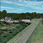
I was flying around the FSX world looking for a real world sloping airstrip just begging to be modeled with a touchdown tire squealing, smoking rubber - that kind of hardened surface sloping runway after I finally figured out how to persuade the FSX SDK to compile one. The Airfield Candidate shall have high density LiDAR elevation and high resolution Orthoimagery data available for public download. I was flying a Beechcraft Baron 58 over Wanaque Reservoir in Northeast NJ of all places when I happened upon a photo scenery runway on a sloping hill top without the usual FSX flattened airport plateau effect and FSX textured runway. They have missed this one ! Hello JY43. - Wally-Bob
| Filename: | JY43_Hill_Top_Airport_NJ.zip |
| License: | Freeware, limited distribution |
| Added: | 9th March 2011, 23:20:14 |
| Downloads: | 1,073 |
| Author: | Walter Roberts |
| Size: | 67.74 MB |
| Category: Navigation and ATC - Navigation | |
| Kodiak Sectional Chart Chunks Optimized For Moving Map Application |
|
File Description:
Sectional chart chunks made from the August 2009 Sectional charts at the original scale, formatted in the WGS84 lat/lon geographic coordinate system for GPS, moving map application for flight simulation use.
These chart chunks were converted to the JPEG format for compatibility and size. Coverage is the full Sectional area North and South divided into JPEG tiles. They are about 3k x 3k pixels at 2.5mb with coverage of 90nm x 130nm per tile. Included is also the projection files and world files.
Note: This type of map is a equal grid and no further calibration is needed, only the two points referenced in the world file. Example: for users of FSM Moving Map, just mass import, done.
| Filename: | Kodiak_Sectional_Chart_Chunks_Optimized_For_Moving.zip |
| License: | Freeware |
| Added: | 1st March 2010, 22:12:20 |
| Downloads: | 149 |
| Author: | David Myers |
| Size: | 11.37 MB |
| Category: Navigation and ATC - Navigation | |
| Ketchikan Sectional Chart Chunks Optimized For Moving Map Application |
|
File Description:
Sectional chart chunks made from the August 2009 Sectional charts at the original scale, formatted in the WGS84 lat/lon geographic coordinate system for GPS, moving map application for flight simulation use.
These chart chunks were converted to the JPEG format for compatibility and size. Coverage is the full Sectional area North and South divided into JPEG tiles. They are about 3k x 3k pixels at 2.5mb with coverage of 90nm x 130nm per tile. Included is also the projection files and world files.
Note: This type of map is a equal grid and no further calibration is needed, only the two points referenced in the world file. Example: for users of FSM Moving Map, just mass import, done.
| Filename: | Ketchikan_Sectional_Chart_Chunks_Optimized_For_Mov.zip |
| License: | Freeware |
| Added: | 2nd March 2010, 00:30:36 |
| Downloads: | 193 |
| Author: | David Myers |
| Size: | 7.32 MB |
| Category: Navigation and ATC - Navigation | |
| Juneau Sectional Chart Chunks Optimized For Moving Map Application |
|
File Description:
Sectional chart chunks made from the August 2009 Sectional charts at the original scale, formatted in the WGS84 lat/lon geographic coordinate system for GPS, moving map application for flight simulation use.
These chart chunks were converted to the JPEG format for compatibility and size. Coverage is the full Sectional area North and South divided into JPEG tiles. They are about 3k x 3k pixels at 2.5mb with coverage of 90nm x 130nm per tile. Included is also the projection files and world files.
Note: This type of map is a equal grid and no further calibration is needed, only the two points referenced in the world file. Example: for users of FSM Moving Map, just mass import, done.
| Filename: | Juneau_Sectional_Chart_Chunks_Optimized_For_Moving.zip |
| License: | Freeware |
| Added: | 2nd March 2010, 00:33:13 |
| Downloads: | 218 |
| Author: | David Myers |
| Size: | 12.81 MB |
| Category: Navigation and ATC - Navigation | |
| Fairbanks Sectional Chart Chunks Optimized For Moving Map Application |
|
File Description:
Sectional chart chunks made from the August 2009 Sectional charts at the original scale, formatted in the WGS84 lat/lon geographic coordinate system for GPS, moving map application for flight simulation use.
These chart chunks were converted to the JPEG format for compatibility and size. Coverage is the full Sectional area North and South divided into JPEG tiles. They are about 3k x 3k pixels at 2.5mb with coverage of 90nm x 130nm per tile. Included is also the projection files and world files.
Note: This type of map is a equal grid and no further calibration is needed, only the two points referenced in the world file. Example: for users of FSM Moving Map, just mass import, done.
| Filename: | Fairbanks_Sectional_Chart_Chunks_Optimized_For_Mov.zip |
| License: | Freeware |
| Added: | 3rd March 2010, 05:55:56 |
| Downloads: | 182 |
| Author: | David Myers |
| Size: | 18.33 MB |
| Category: Navigation and ATC - Navigation | |
| Dawson Sectional Chart Chunks Optimized For Moving Map Application |
|
File Description:
Sectional chart chunks made from the August 2009 Sectional charts at the original scale, formatted in the WGS84 lat/lon geographic coordinate system for GPS, moving map application for flight simulation use.
These chart chunks were converted to the JPEG format for compatibility and size. Coverage is the full Sectional area North and South divided into JPEG tiles. They are about 3k x 3k pixels at 2.5mb with coverage of 90nm x 130nm per tile. Included is also the projection files and world files.
Note: This type of map is a equal grid and no further calibration is needed, only the two points referenced in the world file. Example: for users of FSM Moving Map, just mass import, done.
| Filename: | Dawson_Sectional_Chart_Chunks_Optimized_For_Moving.zip |
| License: | Freeware |
| Added: | 6th March 2010, 00:24:10 |
| Downloads: | 142 |
| Author: | David Myers |
| Size: | 17.46 MB |
| Category: Navigation and ATC - Navigation | |
| Cold Bay Sectional Chart Chunks Optimized For Moving Map Application |
|
File Description:
Sectional chart chunks made from the August 2009 Sectional charts at the original scale, formatted in the WGS84 lat/lon geographic coordinate system for GPS, moving map application for flight simulation use.
These chart chunks were converted to the JPEG format for compatibility and size. Coverage is the full Sectional area North and South divided into JPEG tiles. They are about 3k x 3k pixels at 2.5mb with coverage of 90nm x 130nm per tile. Included is also the projection files and world files.
Note: This type of map is a equal grid and no further calibration is needed, only the two points referenced in the world file. Example: for users of FSM Moving Map, just mass import, done.
| Filename: | Cold_Bay_Sectional_Chart_Chunks_Optimized_For_Movi.zip |
| License: | Freeware |
| Added: | 6th March 2010, 00:24:29 |
| Downloads: | 137 |
| Author: | David Myers |
| Size: | 4.41 MB |
| Category: Navigation and ATC - Navigation | |
| Cape Lisburne Sectional Chart Chunks Optimized For Moving Map Application |
|
File Description:
Sectional chart chunks made from the August 2009 Sectional charts at the original scale, formatted in the WGS84 lat/lon geographic coordinate system for GPS, moving map application for flight simulation use.
These chart chunks were converted to the JPEG format for compatibility and size. Coverage is the full Sectional area North and South divided into JPEG tiles. They are about 3k x 3k pixels at 2.5mb with coverage of 90nm x 130nm per tile. Included is also the projection files and world files.
Note: This type of map is a equal grid and no further calibration is needed, only the two points referenced in the world file. Example: for users of FSM Moving Map, just mass import, done.
| Filename: | Cape_Lisburne_Sectional_Chart_Chunks_Optimized_For.zip |
| License: | Freeware |
| Added: | 6th March 2010, 00:24:51 |
| Downloads: | 195 |
| Author: | David Myers |
| Size: | 16.96 MB |
| Category: Navigation and ATC - Navigation | |
| Bethel Sectional Chart Chunks |
|
File Description:
Sectional chart chunks made from the August 2009 Sectional charts at the original scale, formatted in the WGS84 lat/lon geographic coordinate system for GPS, moving map application for flight simulation use.
These chart chunks were converted to the JPEG format for compatibility and size. Coverage is the full Sectional area North and South divided into JPEG tiles. They are about 3k x 3k pixels at 2.5mb with coverage of 90nm x 130nm per tile. Included is also the projection files and world files.
Note: This type of map is a equal grid and no further calibration is needed, only the two points referenced in the world file. Example: for users of FSM Moving Map, just mass import, done.
| Filename: | Bethel_Sectional_Chart_Chunks.zip |
| License: | Freeware |
| Added: | 7th March 2010, 20:50:48 |
| Downloads: | 177 |
| Author: | David Myers |
| Size: | 14.67 MB |
| Category: Navigation and ATC - Navigation | |
| Whitehorse Sectional Chart Chunks Optimized For Moving Map Application |
|
File Description:
Sectional chart chunks made from the August 2009 Sectional charts at the original scale, formatted in the WGS84 lat/lon geographic coordinate system for GPS, moving map application for flight simulation use.
These chart chunks were converted to the JPEG format for compatibility and size. Coverage is the full Sectional area North and South divided into JPEG tiles. They are about 3k x 3k pixels at 2.5mb with coverage of 90nm x 130nm per tile. Included is also the projection files and world files.
Note: This type of map is a equal grid and no further calibration is needed, only the two points referenced in the world file. Example: for users of FSM Moving Map, just mass import, done.
| Filename: | Whitehorse_Sectional_Chart_Chunks_Optimized_For_Mo.zip |
| License: | Freeware |
| Added: | 28th February 2010, 06:29:44 |
| Downloads: | 145 |
| Author: | David Myers |
| Size: | 16.1 MB |
© 2001-2026 AVSIM Online
All Rights Reserved
Privacy Policy |