
Where Flight Simulation Enthusiasts Gather from Around the World!
AVSIM Library - Search Results

| Category: Flight Simulator 2004 - Scenery | |
| St. George (KSGU) / Mesquite (67L), Utah/Nevada, Photo-Scenery (FS9 & FSX) |

|
Images related to this file:
File Description:
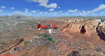
Covers the area between St. George, Utah and Mesquite, Nevada. To the north of St. George
the Pine Valley Mountains with their foothills of scenic red sandstone loom over the city.
St. George Municipal Airport (KSGU) is mostly used for general aviation but is also served by SkyWest Airlines
on behalf of Delta Connection. Because of it's location on a mesa this airport can't be expanded and so a new
airport is currently being built southeast of the city at the site of an abandoned airfield. The opening
is expected in 2011. To the south of the city make sure, you don't miss the Virgin River Gorge where the
Virgin River winds thru a long winding canyon in the transition zone between the red rocks of southern Utahs
Colorado Plateau and Nevadas Mojave Desert. Shortly afterwards you reach Mesquite which is situated just
west of the Arizona stateline. Like nearly all Nevada cities near the stateline Mesquite is home to several
Casinos. Mesquite Airport (67L) lies just north of the city.
High resolution versions of this scenery for FS9 and FSX (much sharper, but larger and multiple downloads)
are available at www.blueskyscenery.com/CNY_South3West6.html . The screenies are taken from the high-res versions,
so expect this version to be slightly more blurry. Thanks to Joop Mak for providing custom AFCADs that
correct airport layouts so that they align with the photo-textures! They are available at www.blueskyscenery.com/AFCADs.html .
YourDonation@Work: Dedicated to Werner, Ralf-Peter and Nels.
| Filename: | St_George_KSGU__Mesquite_67L_UtahNevada_PhotoScene.zip |
| License: | Freeware, limited distribution |
| Added: | 24th March 2010, 19:41:43 |
| Downloads: | 1,649 |
| Author: | Gottfried Razek - blueskyscenery.com |
| Size: | 95.58 MB |
| Category: Flight Simulator 2004 - Scenery | |
| Page (KPGA), Lake Powell West, Utah/Arizona, Photo-Scenery (FS9 & FSX) |
|
Images related to this file:
File Description:
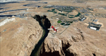
This scenery covers the western part of Lake Powell, the city of Page (KPGA), the Vermillion Cliffs, Glenn Canyon just south of Glenn Canyon Dam, the northern part of Marble Canyon, Paria Canyon, Cockscomb, etc, etc. Spectacular! To explore the scenery depart from Page Municipal Airport (KPGA). High resolution versions of this scenery for FS9 and FSX (much sharper, but larger and multiple downloads) are available at www.blueskyscenery.com/CNY_South3West3.html . The screenies are taken from the high-res versions, so expect this version to be slightly more blurry. YourDonation@Work: Dedicated to William, Veit and Michele.
| Filename: | Page_KPGA_Lake_Powell_West_UtahArizona_PhotoScener.zip |
| License: | Freeware, limited distribution |
| Added: | 3rd March 2010, 21:26:32 |
| Downloads: | 1,817 |
| Author: | Gottfried Razek - blueskyscenery.com |
| Size: | 92.41 MB |
| Category: Flight Simulator 2004 - Scenery | |
| Park County, Colorado, Photo-Scenery (FS9 & FSX) |
|
Images related to this file:
File Description:

Covers the gap between my Leadville and Colorado Springs North sceneries and provides you with continuous coverage for longer cross country flights. High resolution versions of this scenery for FS9 and FSX (much sharper, but larger and multiple downloads) are available at www.blueskyscenery.com/GNB_South2.html . The screenies are taken from the high-res versions, so expect this version to be slightly more blurry. YourDonation@Work: Dedicated to Arthur and Pierre-Alain.
| Filename: | Park_County_Colorado_PhotoScenery_FS9__FSX.zip |
| License: | Freeware, limited distribution |
| Added: | 3rd February 2010, 22:19:58 |
| Downloads: | 1,420 |
| Author: | Gottfried Razek - blueskyscenery.com |
| Size: | 89.49 MB |
| Category: Flight Simulator 2004 - Scenery | |
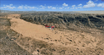
| Comb Ridge, Rock Point (49AZ), Utah/Arizona, Photo-Scenery |
|
Images related to this file:
File Description:

Comb Ridge, Rock Point (49AZ), Utah/Arizona, Photo-Scenery (FS9 & FSX)
This scenery extends my Monument Valley scenery to the east. It covers the area between the San Juan River in the north down to Rock Point, AZ (49AZ). Most of the scenery lies on the Navajo Nation Reservation. It completes the southeastern corner of Utah and paves our way into Colorado.
High resolution versions of this scenery for FS9 and FSX (much sharper, but larger and multiple downloads) are available at www.blueskyscenery.com/CNY_South3West6.html . The screenies are taken from the high-res versions, so expect this version to be slightly more blurry. Thanks to Joop Mak for providing custom AFCADs that correct airport layouts so that they align with the photo-textures! They are available at www.blueskyscenery.com/AFCADs.html . YourDonation@Work: Dedicated to Olivier, Kevin and Ruben.
| Filename: | Comb_Ridge_Rock_Point_49AZ_UtahArizona_PhotoScener.zip |
| License: | Freeware, limited distribution |
| Added: | 9th April 2010, 21:57:41 |
| Downloads: | 1,355 |
| Author: | Gottfried Razek, blueskyscenery.com |
| Size: | 90.99 MB |
| Category: Flight Simulator 2004 - Scenery | |
| Grand Staircase Escalante National Monument/East, Escalante (1L7), Utah, Photo-Scenery (FS9 & FSX) |
|
Images related to this file:
File Description:
This scenery contains the eastern part of the Grand Staircase Escalante National Monument. It extends from the town of Escalante down south where it connects with the Page/Lake Powell scenery. Contains the upper part of wonderful Escalante Canyon. To explore the scenery depart from Escalante Airport (1L7). Thanks to Joop Mak for providing a custom AFCAD that corrects the airport layout so that it matches with the photo-textures! High resolution versions of this scenery for FS9 and FSX (much sharper, but larger and multiple downloads) are available at www.blueskyscenery.com/CNY_South2West3.html . The screenies are taken from the high-res versions, so expect this version to be slightly more blurry. YourDonation@Work: Dedicated to Jay, Donald and Franz
| Filename: | Grand_Staircase_Escalante_National_MonumentEast_Es.zip |
| License: | Freeware, limited distribution |
| Added: | 4th March 2010, 22:44:30 |
| Downloads: | 1,485 |
| Author: | Gottfried Razek - blueskyscenery.com |
| Size: | 96.2 MB |
| Category: Flight Simulator 2004 - Scenery | |
| Bryce Canyon National Park (KBCE), Utah, Photo-Scenery |
|
Images related to this file:
File Description:
Bryce Canyon National Park (KBCE), Utah, Photo-Scenery (FS9 & FSX)
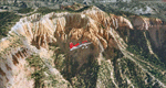
Despite its name, Bryce Canyon is not actually a canyon that was formed by a river, but rather a giant natural cliff shaped through erosion by wind, water, and ice. Bryce is distinctive due to its geological formations, delicate and colorful pinnacles called hoodoos that are up to 200ft high. The bizarre forms and red, orange and white colors of the rocks provide spectacular views. Unfortunately the hoodoos are too small for the elevation mesh in flight simulator. But you can enjoy the colors and shape of the cliffs. The cliffs in main region of the park, just south of the airport are partly covered
by snow. But on the southern and western part of the plateau you can enjoy them free of snow. Bryce Canyon is named after the Mormon pioneer Ebenezer Bryce who settled in this area in the 1850s. It was designated as a national park in 1928.
Bryce Canyon Airport (KBCE) just handles small aircraft on a daily basis. But is was actually built to handle larger aircraft in case of emergency. And so on Oct.6th 2000 an American Airlines MD-82 from Denver to Los Angeles made a successful emergency landing after reporting smoke in the cockpit and a loss of cabin pressure.
High resolution versions of this scenery for FS9 and FSX (much sharper, but larger and multiple downloads)are available at www.blueskyscenery.com/CNY_South2West4.html . The screenies are taken from the high-res versions, so expect this version to be slightly more blurry. Thanks to Joop Mak for providing a custom AFCADs that correct airport layouts so that they align with the photo-textures! They are available here: www.blueskyscenery.com/AFCADs.html . YourDonation@Work: Dedicated to Michael, Pat and Keith.
| Filename: | Bryce_Canyon_National_Park_KBCE_Utah_PhotoScenery.zip |
| License: | Freeware, limited distribution |
| Added: | 7th March 2010, 11:17:56 |
| Downloads: | 2,204 |
| Author: | Gottfried Razek, blueskyscenery.com |
| Size: | 96.35 MB |
| Category: Flight Simulator 2004 - Scenery | |
| Kanab (KKNB), Utah/Arizona, Photo-Scenery (FS9 & FSX) |
|
Images related to this file:
File Description:
This scenery covers the southwestern part of Grand Staircase-Escalante National Monument. From the air
you can see all the "stairs" from the Pink Cliffs of Bryce Canyon in the north down to the Grey Cliffs,
the White Cliffs and the Vermillion Cliffs just north of Kanab and then the Chocolate Cliffs further south.
Nothwest of Kanab you can fly above beautiful Coral Pink Sand Dunes State Park which features coral-hued
sand dunes located beside red sandstone cliffs. These dunes consist of sand that formed thru erosion of
pink colored Navajo Sandstone surrounding the park and was deposited by wind. To explore the scenery depart
from Kanab Airport (KKNB).
High resolution versions of this scenery for FS9 and FSX (much sharper, but larger and multiple downloads)
are available at www.blueskyscenery.com/CNY_South3West4.html . The screenies are taken from the high-res versions,
so expect this version to be slightly more blurry. Thanks to Joop Mak for providing custom AFCADs that
correct airport layouts so that they align with the photo-textures! They are available at
www.blueskyscenery.com/AFCADs.html . YourDonation@Work: Dedicated to Jesper, Fabrizio and Glen.
| Filename: | Kanab_KKNB_UtahArizona_PhotoScenery_FS9__FSX.zip |
| License: | Freeware, limited distribution |
| Added: | 10th March 2010, 22:24:53 |
| Downloads: | 1,506 |
| Author: | Gottfried Razek - blueskyscenery.com |
| Size: | 95.36 MB |
| Category: Flight Simulator 2004 - Scenery | |
| Kremmling, Mc Elroy (20V), Colorado, Photo-Scenery |
|
Images related to this file:
File Description:

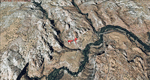
Kremmling, Mc Elroy (20V), Colorado, Photo-Scenery (FS9 & FSX)
Ever wanted to know how the scenery looks like around Kremmling VOR? Now you got the chance! This region covers the area around Kremmling and the northern part of the Gore Range. At Kremmling the Colorado River meets both the Blue River and the Muddy Creek. West of Kremmling you can see Gore Canyon. This rugged and steep canyon is almost 1000ft deep and was carved by the Colorado River on its way thru the Gore Range.
To explore the scenery depart from Mc Elroy Airfield (20V) in Kremmling and head north. High resolution versions of this scenery for FS9 and FSX (much sharper, but larger and multiple downloads) are available at www.blueskyscenery.com/GNB_West.html . The screenies are taken from the high-res versions, so expect this version to be slightly more blurry. Thanks to Joop Mak for providing custom AFCADs that correct airport layouts so that they align with the photo-textures! They are available at www.blueskyscenery.com/AFCADs.html . YourDonation@Work: Dedicated to Michael.
| Filename: | Kremmling_Mc_Elroy_20V_Colorado_PhotoScenery.zip |
| License: | Freeware, limited distribution |
| Added: | 21st April 2010, 17:39:09 |
| Downloads: | 1,138 |
| Author: | Gottfried Razek, blueskyscenery.com |
| Size: | 91.2 MB |
| Category: Flight Simulator 2004 - Scenery | |
| Colorado Springs North, Colorado, Photo-Scenery (FS9 & FSX) |
|
Images related to this file:
File Description:
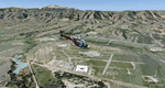
This region covers the area between Denver and Colorado Springs. It extends my Denver scenery to the south.
Just north of Colorado Springs you can see the widespread United States Air Force Academy which, with it's
many buildings, covers a huge area of 18.000 acres. The Academy Airfield (KAFF) which lays in the northeastern
corner of the area is used for training cadets in airmanship courses, including parachute training,
soaring and powered flight.
High resolution versions of this scenery for FS9 and FSX (much sharper, but larger and multiple downloads)
are available at www.blueskyscenery.com/GNB_South2East.html . The screenies are taken from the high-res versions,
so expect this version to be slightly more blurry. YourDonation@Work: Dedicated to Robin and Raymond.
| Filename: | Colorado_Springs_North_Colorado_PhotoScenery_FS9__.zip |
| License: | Freeware, limited distribution |
| Added: | 3rd February 2010, 02:09:59 |
| Downloads: | 2,186 |
| Author: | Gottfried Razek - blueskyscenery.com |
| Size: | 96.91 MB |
| Category: Flight Simulator 2004 - Scenery | |
| Las Vegas (KLAS), Nevada, Photo Scenery (FSX too) |
|
Images related to this file:
File Description:

This package contains photo-scenery for the greater area of Las Vegas, covering an area of 3.250 sq km and is dedicated to the donators Donald, John and David. The scenery reaches from the foothills of Mt. Charleston to Lake Mead (partly covered). The quality is in standard FS2004-resolution of 4.7m/pixel. It works equally well in FS2004 and FSX. Hi-Res overlays fill follow. For a complete list of available titles please visit us at www.blueskyscenery.com
| Filename: | Las_Vegas_KLAS_Nevada_Photo_Scenery_FSX_too.zip |
| License: | Freeware, limited distribution |
| Added: | 30th December 2009, 18:01:52 |
| Downloads: | 10,851 |
| Author: | Gottfried Razek - blueskyscenery.com |
| Size: | 80.59 MB |
© 2001-2026 AVSIM Online
All Rights Reserved
Privacy Policy |