
Where Flight Simulation Enthusiasts Gather from Around the World!
AVSIM Library - Search Results

| Category: Flight Simulator X - Scenery | |
| ENFG_Fagernes/Leirin, Norway for FSX |

|
Images related to this file:
File Description: The airport ENFG is situated about 4 kilometers northeast of the city of Fagernes in the municipal of Nord-Aurdal, Oppland, about 120 miles northeast from Oslo.
The altitude of ENFG is 822 m / 2,697 ft. The airport is very close to the important rocks of Jutunheimen. The senery has a photo background that covers all four seasons: spring, summer, autumn and winter. The surroundings are made via new landclasses which fit mostly the reality. Also all lakes and rivers are updated. The buildings in this scenery are mostly taken from the fantastic XPlane scenery made by Hans Kristian Braaten Olsen, who kindly gave me permission to use his buildings in this scenery. I prepared them for FSX and partly reworked them a bit.
| Filename: | enfg_fsx_ver1.0.zip |
| License: | Freeware |
| Added: | 5th October 2019, 18:01:05 |
| Downloads: | 464 |
| Author: | Wolfgang Allers |
| Size: | 245.88 MB |
| Category: Prepar3D V1-4 - Scenery | |
| ENFG_Fagernes/Leirin, Norway for P3DV4 |
|
Images related to this file:
File Description: The airport ENFG is situated about 4 kilometers northeast of the city of Fagernes in the municipal of Nord-Aurdal, Oppland, about 120 miles northeast from Oslo.
The altitude of ENFG is 822 m / 2,697 ft. The airport is very close to the imposant rocks of Jutunheimen. The senery has a photo background that covers all four seasons: spring, summer, autumn and winter. The surroundings are made via new landclasses which fit mostly the reality. Also all lakes and rivers are updated. The buildings in this scenery are mostly taken from the fantastic XPlane scenery made by Hans Kristian Braaten Olsen, who kindly gave me permission to use his buildings in this scenery. I prepared them for FSX and partly reworked them a bit.
| Filename: | ENFG_FagernesLeirin_Norway_for_P3DV4.zip |
| License: | Freeware |
| Added: | 5th October 2019, 18:03:21 |
| Downloads: | 471 |
| Author: | Wolfgang Allers |
| Size: | 245.14 MB |
| Category: Flight Simulator 2004 - Scenery | |
| Alverca AB, LPAR (near Lisbon, Portugal) including AI-Package |
|
File Description:
About 10 NM north of Lisbon City (Portugal) there is this beautiful, close to the Atlantic Ocean located Portuguese Airbase. The Alverca AB scenery goes along well with the Project Lisbon Photoreal PLPv3.2 scenery available at avsim. The included AI-Package contains: USAF Douglas C-47 Dakota and C-64 Skymaster, Breitling Lockheed L-1049 Super Constellation, FAP (Forca Aerea Portuguesa) Lockheed C-130H and T-33A, Lockheed-Martin F-16C, North American F-86F, FAP and GAF (German Air Force) Nord-Aviation Noratlas and the new GAF British-Aerospace Eurofighter Typhoon. The above airplanes perform touch and goes at the local airbase per attched flightplan. This scenery was made with EZ-Scenery. No FSE or other payware is required. Gentlemen, line up and standby for takeoff clearance!
| Filename: | Alverca_AB_LPAR_near_Lisbon_Portugal_including_AIP.zip |
| License: | Freeware, limited distribution |
| Added: | 4th April 2006, 22:14:40 |
| Downloads: | 8,632 |
| Author: | Klaus Jone |
| Size: | 30.16 MB |
| Category: Prepar3D V1-4 - Aircraft Repaints, Textures and Modifications | |
| North American P-51D 20th FG (LC-N) 'June Nite' |
|
Images related to this file:
File Description:

This folder contains a repaint for the A2A WoP3 P-51D Mustang (with AccuSim), in the colors of P-51K 44-11161 LC-N "June Nite" as flown by Ernest "Feeb" Fiebelkorn of the 20th FG. He was one of the biggest aces of the 8th Air Force, meaning tallest and heaviest. 6ft 4in combined with 225 pounds must have made a placement into the Mustang's cockpit a bit problematic.
This did not prevent Feeb from becoming the top-scoring pilot of the 20th Fighter Group. Moreover, it was not Fiebelkorn's only claim to fame. On November 8th 1944 he and Edward Haydon from 357th FG managed to shoot down German Me 262 piloted by then top-scoring ace of the World - Walter Nowotny. The famous Austrian pilot was not lucky enough to survive that onslaught.
Feeb finished the war unscathed only to die in F-82 over Korea. His total score includes 8 individual aerial victories, 2 shared aerial victories and 2 individual ground victories. Repaint by Jan Kees Blom, based on the A2A paintkit.
| Filename: | North_American_P51D_20th_FG_LCN_June_Nite.zip |
| License: | Freeware |
| Added: | 4th November 2018, 17:24:10 |
| Downloads: | 62 |
| Author: | Jan Kees Blom |
| Size: | 13.1 MB |
| Category: Flight Simulator 2004 - Scenery | |
| New Terrain Mesh of the Province of Quebec in LOD09 (3/4) |
|
File Description:
The files in this package contain terrain mesh files of the province of Quebec (N45 to N53) to be used with my Quebec enhanced sceneries for FS2004 (Scenes_du_Quebec_2k4.zip). The public data sources are the Shuttle Radar Topography Mission (SRTM-3, 90m) and the Canadian Digital Elevation Data (CDED - 0.75s/arc - 23m). (QC09_2k4a.zip to QC09_2k4d.zip - 4 parts)
***********************
Les fichiers de ces archives contiennent les donnees d'elevation de terrain (mesh files - lod09), pour FS2004, du territoire de la province de Quebec sous le 53ieme degre de latitude nord. Ils ont ete crees pour etre utilises avec mes nouvelles scenes du Quebec contenues dans Scenes_du_Quebec_2k4.zip. Les donnees sources sont du domaine public et proviennent de la Shuttle Radar Topography Mission (SRTM-3, 90m) et des donnees numerique d'elevation du Canada (DNEC - 0.75s/arc -23 m). (QC09_2k4a.zip to QC09_2k4d.zip - 4 parties)
| Filename: | qc09_2k4c.zip |
| License: | Freeware, limited distribution |
| Added: | 27th January 2010, 18:15:12 |
| Downloads: | 7,485 |
| Author: | Gilles Gauthier |
| Size: | 29.35 MB |
| Category: Flight Simulator 2004 - Scenery | |
| New Terrain Mesh of the Province of Quebec in LOD09 (4/4) |
|
File Description:
The files in this package contain terrain mesh files of the province of Quebec (N45 to N53) to be used with my Quebec enhanced sceneries for FS2004 (Scenes_du_Quebec_2k4.zip). The public data sources are the Shuttle Radar Topography Mission (SRTM-3, 90m) and the Canadian Digital Elevation Data (CDED - 0.75s/arc - 23m). (QC09_2k4a.zip to QC09_2k4d.zip - 4 parts)
***********************
Les fichiers de ces archives contiennent les donnees d'elevation de terrain (mesh files - lod09), pour FS2004, du territoire de la province de Quebec sous le 53ieme degre de latitude nord. Ils ont ete crees pour etre utilises avec mes nouvelles scenes du Quebec contenues dans Scenes_du_Quebec_2k4.zip. Les donnees sources sont du domaine public et proviennent de la Shuttle Radar Topography Mission (SRTM-3, 90m) et des donnees numerique d'elevation du Canada (DNEC - 0.75s/arc -23 m). (QC09_2k4a.zip to QC09_2k4d.zip - 4 parties)
| Filename: | qc09_2k4d.zip |
| License: | Freeware, limited distribution |
| Added: | 27th January 2010, 18:17:08 |
| Downloads: | 7,843 |
| Author: | Gilles Gauthier |
| Size: | 20.94 MB |
| Category: Flight Simulator 2004 - Scenery | |
| New Terrain Mesh of the Province of Quebec in LOD09 (1/4) |
|
File Description:
The files in this package contain terrain mesh files of the province of Quebec (N45 to N53) to be used with my Quebec enhanced sceneries for FS2004 (Scenes_du_Quebec_2k4.zip). The public data sources are the Shuttle Radar Topography Mission (SRTM-3, 90m) and the Canadian Digital Elevation Data (CDED - 0.75s/arc - 23m). (QC09_2k4a.zip to QC09_2k4d.zip - 4 parts)
***********************
Les fichiers de ces archives contiennent les donnees d'elevation de terrain (mesh files - lod09), pour FS2004, du territoire de la province de Quebec sous le 53ieme degre de latitude nord. Ils ont ete crees pour etre utilises avec mes nouvelles scenes du Quebec contenues dans Scenes_du_Quebec_2k4.zip. Les donnees sources sont du domaine public et proviennent de la Shuttle Radar Topography Mission (SRTM-3, 90m) et des donnees numerique d'elevation du Canada (DNEC - 0.75s/arc -23 m). (QC09_2k4a.zip to QC09_2k4d.zip - 4 parties)
| Filename: | New_Terrain_Mesh_of_the_Province_of_Quebec_in_LOD09_14.zip |
| License: | Freeware, limited distribution |
| Added: | 27th January 2010, 18:10:18 |
| Downloads: | 8,904 |
| Author: | Gilles Gauthier |
| Size: | 23.76 MB |
| Category: Flight Simulator 2004 - Scenery | |
| New Terrain Mesh of the Province of Quebec in LOD09 (2/4) |
|
File Description:
The files in this package contain terrain mesh files of the province of Quebec (N45 to N53) to be used with my Quebec enhanced sceneries for FS2004 (Scenes_du_Quebec_2k4.zip). The public data sources are the Shuttle Radar Topography Mission (SRTM-3, 90m) and the Canadian Digital Elevation Data (CDED - 0.75s/arc - 23m). (QC09_2k4a.zip to QC09_2k4d.zip - 4 parts)
***********************
Les fichiers de ces archives contiennent les donnees d'elevation de terrain (mesh files - lod09), pour FS2004, du territoire de la province de Quebec sous le 53ieme degre de latitude nord. Ils ont ete crees pour etre utilises avec mes nouvelles scenes du Quebec contenues dans Scenes_du_Quebec_2k4.zip. Les donnees sources sont du domaine public et proviennent de la Shuttle Radar Topography Mission (SRTM-3, 90m) et des donnees numerique d'elevation du Canada (DNEC - 0.75s/arc -23 m). (QC09_2k4a.zip to QC09_2k4d.zip - 4 parties)
| Filename: | New_Terrain_Mesh_of_the_Province_of_Quebec_in_LOD0.zip |
| License: | Freeware, limited distribution |
| Added: | 1st November 2009, 06:47:09 |
| Downloads: | 4,617 |
| Author: | Gilles Gauthier |
| Size: | 27.78 MB |
| Category: Flight Simulator 2004 - Scenery | |
| Reworked Altenstadt Army airfield, ETHA (Bavaria, South-Germany) including AI-Package |
|
File Description:
This airfield, located near Schongau in the Allgaeu (Bavaria, South-Germany),
is the main training center for parachuters of the German Army and used for cargo-drop missions of various users. The airport has been reworked to improve
the overall appearance. Version 2 replaces V1 completely.
The included AI-Package contains: Bell UH-1D SAR, Nord-Aviation Noratlas ND2501,
North-American T-6D and an aircraft.cfg for an AI-Transall C160.
Two Transall and a single T-6D from Landsberg and two Noratlas from Kaufbeuren
are comming over for touch and goes at Altenstadt as scheduled per attached
flightplan. A Dornier Do-28 does local touch and goes and a Bell UH-1D SAR-helicopter hurries to Landsberg. Welcome to a little Xmas party.
Lago's FSE is required in order to see most of the major buildings / objects.
| Filename: | altenstadt-v2_fs2004.zip |
| License: | Freeware, limited distribution |
| Added: | 24th December 2005, 17:48:42 |
| Downloads: | 2,418 |
| Author: | Klaus Jone |
| Size: | 4.01 MB |
| Category: Flight Simulator 2004 - Scenery | |
| Wunstorf AB - Germany |
|
Images related to this file:
File Description:
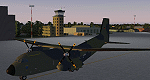
Wunstorf Air Base was originally opened in 1936 for the National Socialist Luftwaffe. Like most German airfields it did arduous duty during the Second World War. When the allies finally concluded their occupation the field was eventually returned to German control and hosted it's first German transport unit flying the Nord Atlas. This aircraft was replaced in 1971 with the current Transall 160 aircraft. With the recent adoption of the Airbus A400M by the Luftwaffe, Wunstorf is undergoing some significant remodeling including lengthening of runway 8-26 as well as construction of two new modern hangars and associated support buildings. This scenery is intended to be used with the great Transall 160 package by Ray Parker (available at Avsim.net as (gaf_c-160_transall.zip) but will of course accomodate any aircraft and is in itself a complete scenery package.
| Filename: | etnw_js.zip |
| License: | Freeware, limited distribution |
| Added: | 13th April 2014, 14:08:22 |
| Downloads: | 1,471 |
| Author: | John Stinstrom |
| Size: | 6.58 MB |
© 2001-2025 AVSIM Online
All Rights Reserved