
Where Flight Simulation Enthusiasts Gather from Around the World!
AVSIM Library - Search Results

| Category: Flight Simulator 2004 - Aircraft Repaints, Textures and Modifications | |
| KLM Convair CV-240 VBF CA-18 |

|
Images related to this file:
File Description:
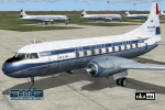
Convair CV-240-4, cn 145, delivered to KLM Royal Dutch Airlines on February 28, 1949 and registered PH-TEM, named "Meindert Hobbema". Re-registered PH-CEM on March 6, 1954. Bought by Deutsche Flugdienst GmbH on October 28, 1957 and registered D-BOBA. Leased to Lufthansa on September 12, 1960. On November 1, 1961 the "Deutsche Flugdienst GmbH" was renamed to "Condor Flugdienst". On October 3, 1962 cn 145 was bought by Houston Aviation Products. Further on cn 145 served for a lot of different operators in the United States. The last flight of this aircraft is recorded for November 20, 2007. The FAA Registry still shows
ARGO CARIBBEAN AIR INC. as the owner of N707AW.Textures and associated model file included only. Requires cv240VBFca18_basepack_010.ZIP. Original by Greg Pepper & Tom Gibson, upgraded by Georg Hauzenberger (model) and Hans Hermann (textures) Virtual Birds Factory, November 2010
| Filename: | KLM_Convair_CV240_VBF_CA18.zip |
| License: | Freeware, limited distribution |
| Added: | 6th November 2010, 20:41:14 |
| Downloads: | 449 |
| Author: | Georg Hauzenberger and Hans Hermann |
| Size: | 4.45 MB |
| Category: Flight Simulator 2004 - AI Flight Plans | |
| Retro Spangdahlem AB USAF 52nd Tactical Fighter Wing |
|
Images related to this file:
File Description:

Retro AI flightplans and individual repaints for 78 aircraft of the Unites States Air Force 23 TFS, 81 TFS and 480 TFS of 52 TFW based at Spangdahlem [ETAD], Germany [version 2.0]. Two basic options included... Spangdahlem 1985: all three squadrons are equiped with F-4E and F-4G Phantoms all painted in "Euro1". Spangdahlem 1988: all three squadrons are equiped with F-16C/D Falcons and F-4G Phantoms of which most Phantoms are painted in "Euro1" and some of them in the grey "Hill" colour scheme. All the flightplans were individually tailored for the aircraft manually. This is to give a more realistic set of flightplans and is a massive update of Version 1.0 with retro destinations and additional flightplans added together with revised departure/arrival times. Callsigns by Stewart Pearson included. See also included readme file for more details on this package...
| Filename: | Retro_Spangdahlem_AB_USAF_52nd_Tactical_Fighter_Wi.zip |
| License: | Freeware, limited distribution |
| Added: | 15th April 2013, 20:13:02 |
| Downloads: | 1,217 |
| Author: | Chris A Brown and Eric Kunst |
| Size: | 70.68 MB |
| Category: Flight Simulator 2002 - Original Aircraft | |
| VF-84 Squadron U.S.N. SA-43 Hammerhead |
|
File Description:
The nose gun is now tied to the stick movement same as the rest of the new SA-43's.Panel from a Chuck Dome original.This one is in the markings of Cmdr. Cal Groom, VF-84 'Jolly rogers'. This was done at the request of a SAAB and USN fan. Sound from the default Learjet but sound pack recommendations in the readme file. Original MDL and Air file by M. D. Anderle from his X-32. Model created by Ian Lawrence.
The weapons package is a mixed task of air to air and air to ground, consisting of :
2 AGM-113 Ranger long range attack missiles with standoff capability and onboard electronic and visual IFF equipment capable of autonomus attack profile and target selection and armed with a high yield blast warhead.
In addition it carries 4 AAM-9X Sidewinder 4 misssiles against aerial targets.
| Filename: | VF84_Squadron_USN___SA43_Hammerhead.zip |
| License: | Freeware, limited distribution |
| Added: | 27th September 2003, 19:39:59 |
| Downloads: | 1,222 |
| Author: | Ian Lawrence |
| Size: | 3.34 MB |
| Category: Orbiter - Spaceships | |
| Salyut 4 - Soyuz 17 |
|
File Description:
***REQUIREMENTS***
spacecraft.dll,
launch scenarios require D. Henderson's CVE-lite 'Proton-k' and 'Soyuz-Launchers' (available at orbiterhangar - www.orbithangar.com/searchauth.cfm?search=dh219, and sourceforge - sourceforge.net/project/showfiles.php?group_id=58685)
***INSTALLATION***
unzip with full paths option to orbiter's root folder.
***USE***
on orbit, jettison each craft to it's on-orbit configuration (sorry, no animations yet...) with the 'j' key (make sure to press 'j' only once with the soyuz or else you'll endup separating the orbital module... doh!!)
'j' key also jettisons the soyuz's orbital module (BO) and propulsion module (PAO) from the reentry capsule (SA)...
also, no parachutes yet for the SA (still working out the details and data on that yet), so have fun on reentry as it'll be your last, cosmonaut!
***NOTES***
the soyuz7k-t included is a new (and hopefully improved) version of my previous one; the salyut4 station is all new...
enjoy!
cheers
hc
| Filename: | Salyut_4__Soyuz_17.zip |
| License: | Freeware |
| Added: | 28th January 2006, 04:25:18 |
| Downloads: | 604 |
| Author: | Hans Castorp |
| Size: | 4.2 MB |
| Category: Flight Simulator 2004 - Aircraft Repaints, Textures and Modifications | |
| Fuerza Aerea Paraguaya C-47A FAP-2004 |
|
File Description:
Fuerza Aerea Paraguaya C-47A-65-DL FAP-2004,C/N 19001 builded by the Long Beach City production plant for the USAAF as 42-100538.This plane has suffered a early accident over the Lake Michigan in his training phase;deployed in England with the 80th Airborne Troop Carrier,participed in Normandy,Arhem and Bastogne operations.With the Fuerza Aerea Paraguaya first as T-41 and then 2004.FAP-2004 was one of the four C-47A operated by the FAP;most of the models deployed with the Fuerza Aerea Paraguaya
were types C-47B.The base textures for repainting are by Mark Beaumont, original textures are by Jan Visser.Repainted by Daniel Nole.In order to use these textures, you must already have the MAAM-SIM payware DC3 and the MAAM-SIM D-Day C-47 'Skytrain'and Dakota Mk III Expansion Pack installed in your FS2004 aircraft folder.
| Filename: | Fuerza_Aerea_Paraguaya_C47A_FAP2004.zip |
| License: | Freeware |
| Added: | 16th October 2005, 17:34:40 |
| Downloads: | 252 |
| Author: | Daniel Nole |
| Size: | 7.93 MB |
| Category: Flight Simulator 2004 - Aircraft Repaints, Textures and Modifications | |
| Fuerza Aerea Argentina C-47A-1-DK T-22 |
|
File Description:
Fuerza Aerea Argentina C-47A-1-DK T-22,C/N 12190 builded by the Oklahoma City
production plant for the USAAF as 42-92394.Ex brazilian REAL PP-YPV,flew latter with the Fuerza Aerea Argentina also as TC-22.The first C-47s were received by the Fuerza Aerea Argentina in 1947 and also two C-47s were the first Argentinian planes to land at the South Pole,the 6th Jan 1962, by the Argentina Navy crews(Cap. de Fragata Hermes Quijada y el Tte. de Navío Jorge Pittalunga).The base textures for repainting are by Mark Beaumont,original textures are by Jan Visser.Repainted by Daniel Nole.In order to use these textures, you must already have the MAAM-SIM payware DC3 and the MAAM-SIM D-Day C-47 'Skytrain' and Dakota Mk III Expansion Pack installed in your FS2004 aircraft folder.
| Filename: | Fuerza_Aerea_Argentina_C47A1DK_T22.zip |
| License: | Freeware |
| Added: | 5th August 2005, 20:59:24 |
| Downloads: | 356 |
| Author: | Daniel Nole |
| Size: | 6.95 MB |
| Category: Flight Simulator X - Original Aircraft | |
| JELAIR - Spaceshuttle Orbiter Enterprise - v2008-05-22 |
|
File Description:
!!! NEW ZIP-FILE !!! If you had trouble with the previous zip-file (if it didn't unzip at all, or if files where missing after unzipping, etc) you should get this one instead. The filenames have been changed to make sure it unzips on all systems --- About this addon: The approach&landing test spaceshuttle orbiter "Enterprise". This is the orbiter-vehicle NASA used to test the landing phase with before launching the first spaceshuttle into space. It has no 3-D model, but a detailed FDE based on available information. It has panel and sound included. It has addon-scenery for Kennedy Space Center included. It can fly a fully automated flight from lift-off to wheel-stop from anywhere in the FSX-world (the last 22 miles of gliding unpowered approach-phase is fairly realistically simulated, but the lift-off and flight uses slew and engine-power)
| Filename: | JELAIR__Spaceshuttle_Orbiter_Enterprise__v20080522.zip |
| License: | Freeware |
| Added: | 22nd May 2008, 21:13:13 |
| Downloads: | 2,909 |
| Author: | Jacob Larsen |
| Size: | 3.45 MB |
| Category: Prepar3D V1-4 - Scenery | |
| LIRF - Fiumicino Intl Airport, Rome, Italy |
|
Images related to this file:
File Description:
This is Ray Smith's FSX file. Ray has given me permission to modify his file for P3Dv4. This is a very accurate version of Fiumicino International Airport with two optional files, one file with the Crosswind runway activated and in full operation, where all 3 runways will be used for takeoff/landing and one file as the default airport runway operation. Runway 16C/34C is closed and now taxiway "D". Although 16C/34C is still used under certain visibility conditions P3Dv4 will only allow one or the other. Assigned parking as per their website with extra parking including gates for the A380. The new Terminal 3 expansion added. Gates/parking now numbered in the correct order. All ILS approaches, taxiways and taxi signs updated and corrected to the latest charts. Extra fuel trucks, support vehicle roads rebuilt and many other scenery improvements and objects added.
| Filename: | LIRF__Fiumicino_Intl_Airport_Rome_Italy.zip |
| License: | Freeware |
| Added: | 15th May 2018, 19:07:03 |
| Downloads: | 26,876 |
| Author: | Robert Catherall |
| Size: | 2.48 MB |
| Category: Flight Simulator X - Aircraft Repaints, Textures and Modifications | |
| Boeing B-17G 91st BG (OR-K) "Shirley Jean" |
|
Images related to this file:
File Description:
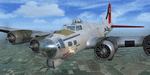
This folder contains a repaint for the A2A WoP2 B-17G in the colors of B-17 42-107040 Shirley Jean, assigned to the 91st BG in Bassingbourn, UK. It which was a B-17G and was named after the crew chief's two daughters. The nose art was done by Tony Starcer and was taken from Esquire's Vargas Girl Calendar, August 1943. she flew 7 combat sorties with the 324th as DF-D, was transferred to the 323rd on 1 april as OR-K, then came back to the 324th in the latter part of August 1944. This paint shows her when she was flying with the 323rd BS. Shirley Jean survived the war with the 91st with a total of 98 missions during 18 months of combat. Her last mission was on March 8, 1945 which was approximately six weeks before the 91st Group's last mission.
Repaint by Jan Kees Blom, based on the A2A paintkit.
| Filename: | Boeing_B17G_91st_BG_ORK_Shirley_Jean.zip |
| License: | Freeware |
| Added: | 7th October 2019, 18:22:06 |
| Downloads: | 94 |
| Author: | Jan Kees Blom |
| Size: | 19.66 MB |
| Category: Microsoft Flight Simulator (2020) - Aircraft Repaints, Textures and Modifications | |
| Supermarine Spitfire Mk.IX (OO-ARE) |
|
Images related to this file:
File Description:
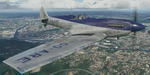
This folder contains a repaint for the Spitfire Mk.IX by FlyingIron, in the colors of Spitfire LF IXc OO-ARE as it looked around 1960 when flying as a target tug with Cogea in Belgium. Originally NH238, it went to the Dutch Air Force in 1946, where it flew as H-60 and H-103. It went to the Belgian Air Force in 1952, becoming SM-36. It was sold to Cogea of Ostend in 1956, and was used as a target tug until 1961 with the registration OO-ARE. It was sold to the UK, becoming G-MKIX. It was damaged from a ground fuel explosion in Exter in 1961, but restored again. It went to the US in 1969, where it became N238V, returning to the UK again in 1979. It was last flown as NH238/D-A, but it was removed from the registry in 2002. It is rumored to be in storage at Greenham Common. Repaint by Jan Kees Blom.
| Filename: | Supermarine_Spitfire_MkIX_OOARE.zip |
| License: | Freeware |
| Added: | 1st April 2021, 19:02:33 |
| Downloads: | 19 |
| Author: | Jan Kees Blom |
| Size: | 55.28 MB |


© 2001-2026 AVSIM Online
All Rights Reserved
Privacy Policy |