
Where Flight Simulation Enthusiasts Gather from Around the World!
AVSIM Library - Search Results

| Category: Flight Simulator 2004 - Flight Plans | |
| OB-11 Richmond KY (Old) |

|
Images related to this file:
File Description:
FS2004 Flight Plan for OB-11 Richmond KY (Old) IFR high speed low altitude military training route. This is the fifth in a series of flight plans I have uploaded. These are great routes for B-52, F-111, B-1B, B-2 A6, A4, Vulcan and any fighter or bomber enthusiasts. Of course you can fly the route with any aircraft of your choice. Included in this package is a gauge by Karol Chlebowski for TFR flying at very low altitude. This gauge will greatly enhance your ability to fly these challenging routes and is a great companion of the flight plans. Another option to download Version 2.0 of my FS2004 mini panel which has all this functionality and more.
| Filename: | ob-11_richmond_ky_old.zip |
| License: | Freeware |
| Added: | 27th July 2011, 23:03:13 |
| Downloads: | 65 |
| Author: | Bill McClellan |
| Size: | 96 KB |
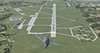
| Category: Flight Simulator X - Flight Plans | |
| Set of three VFR Low Altitude FSX Flight Plans |
|
Images related to this file:
File Description:
Set of three VFR Low Altitude Flight Plans in Florida, Australia, and South Korea. Installation and Usage instructions are inside each individual folder. These are great routes for B-52, F-111, B-1B, B-2 A6, A4, Vulcan and any fighter or bomber enthusiasts. Of course you can fly the routes with any aircraft of your choice. Included in this package are two spectacular gauges by Karol Chlebowski for TFR flying and Pave Tack which includes many advanced features for bombing, navigation and reconnaissance. These two gauges will greatly enhance your ability to fly these challenging routes and are a great companion of the flight plans. Another option to download Version 2.1
of my mini panel which has all this functionality and more.
| Filename: | vfr_routes.zip |
| License: | Freeware |
| Added: | 1st August 2011, 08:32:24 |
| Downloads: | 328 |
| Author: | Bill McClellan |
| Size: | 4.78 MB |
| Category: Flight Simulator X - Scenery | |
| EPKS Poznan-Krzesiny AB Poland Scenery Package with AI Blk52+ CFT F-16s |
|
Images related to this file:
File Description:
This is a complete "plug and play" scenery package for EPKS Poznan-Krzesiny AB that includes two squadrons of "custom painted" Poland AF AI Block 52+ CFT F-16's!
Using Airport Design Editor, MAIW's Scenery Objects, and Google Earth for reference, I did my best to re-create EPKS Poznan-Krzesiny AB for FSX. Since info online about the base is limited, I had to guess about a few things, like taxiway designations and the frequency for the ILS, so apologies for any errors due to that. The 3-ELT and 6-ELT F-16s both have assigned parking in aircraft shelters, but I also created several other "assigned parking areas" around the base for you to add other AI aircraft as you wish.
| Filename: | epks_poznan-krzesiny_ab_poland_with_ai_blk52+_f-16s.zip |
| License: | Freeware |
| Added: | 10th April 2022, 16:45:51 |
| Downloads: | 510 |
| Author: | Daniel W Gregory |
| Size: | 52.46 MB |
| Category: Flight Simulator X - Scenery | |
| The French Polynesia Tuamotu Archipelago Scenery X Part B (Tuamotu-X_B) |
|
File Description:
FSX Scenery FRENCH POLYNESIA TUAMOTU ARCHIPELAGO SCENERY Part B
This scenery improves specific area (Tuamotu Archipelago) of FSX.
The archiperago scattered in the northeast of Tahiti island is composed of 78 islands.
I reproduced the 52 islands in the archipelago as add-on senery.
They are islands like a beautiful necklace sprinkled in the tropical ocean.
The French Polynesia Tuamotu Archipelago Scenery X Part B (Tuamotu-X_B)
includes east side of the whole archipelago because of the file size.
This scenery requires Tuamotu-X_A scenery (fpta-xa.zip).
Please be sure to download the Tuamotu-X_A.
When the Tuamotu-X_A scenery is installed together with this scenery,
the huge Tuamotu Archipelago including all of "The Chain Islands" will appear.
By Kazuo Kawamura
| Filename: | fpta-xb.zip |
| License: | Freeware, limited distribution |
| Added: | 27th February 2010, 07:38:01 |
| Downloads: | 10,965 |
| Author: | Kazuo Kawamura |
| Size: | 78.14 MB |
| Category: Flight Simulator X - Scenery | |
| The French Polynesia Tuamotu Archipelago Scenery X Part A (Tuamotu-X_A) |
|
File Description:
FSX Scenery FRENCH POLYNESIA TUAMOTU ARCHIPELAGO SCENERY Part A
This scenery improves specific area (Tuamotu Archipelago) of FSX.
The archiperago scattered in the northeast of Tahiti island is composed of 78 islands.
I reproduced the 52 islands in the archipelago as add-on senery.
They are islands like a beautiful necklace sprinkled in the tropical ocean.
The French Polynesia Tuamotu Archipelago Scenery X Part A (Tuamotu-X_A)
includes west side of the whole archipelago because of the file size.
This scenery requires Tuamotu-X_B scenery (fpta-xb.zip).
Please be sure to download the Tuamotu-X_B.
When the Tuamotu-X_B scenery is installed together with this scenery,
the huge Tuamotu Archipelago including all of "The Chain Islands" will appear.
By Kazuo Kawamura
| Filename: | fpta-xa.zip |
| License: | Freeware, limited distribution |
| Added: | 27th February 2010, 07:36:22 |
| Downloads: | 10,965 |
| Author: | Kazuo Kawamura |
| Size: | 81.35 MB |
| Category: X-Plane - Scenery | |
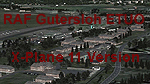
| RAF Gutersloh ETUO |
|
Images related to this file:
File Description:
File Description:
X-Plane 11 Scenery - RAF Gutersloh AB (ICAO: ETUO)
The scenery represents the former airbase of RAF Gutersloh, one of the most populated military bases in West Germany during the Cold War, due to its location near the former East/West border. This scenery reflects the era at the end of the 1980s/beginning of the 90s, when the Harrier GR3 was in operation there, along with Chinook helicopters.
The airfield was built in 1935 and was used by the German Air Force during WW2, flying the Junkers JU-86 and Heinkel H-111. The first British squadrons were stationed there from 1947, with Mosquitos, Vampires and then Canberras.
The first Harrier arrived at Gutersloh in January 1977 and 3 and 4 Squadrons became resident until their farewell in 1993, after the cold war had ended. The airfield is currently used by the British army, but they will leave in 2014 to relinquish the area to the Government of Gutersloh for civil usage.
High detailed scenery by Manfred Schyma and Pete Beeby, supported by the Airfield Construction Group. X-Plane Version designed by Dietmar Hanne
| Filename: | raf_gutersloh_etuo.zip |
| License: | Freeware |
| Added: | 25th May 2018, 23:53:43 |
| Downloads: | 264 |
| Author: | Dietmar Hanne |
| Size: | 147.06 MB |
| Category: Flight Simulator 2004 - Flight Plans | |
| OB-1 Wilder Idaho |
|
File Description:
FS2004 Flight Plan for OB-1 Wilder Idaho IFR high speed low altitude military training route through mountainous terrain in Oregon, Nevada and Idaho. This is the first in a series of FS2004 flight plans I will upload. These are great routes for B-52, F-111, B-1B, B-2 A6, A4, Vulcan and any fighter or bomber enthusiasts. Of course you can fly the route with any aircraft of your choice. Included in this package is a gauge by Karol Chlebowski for TFR flying at very low altitude. This gauge will greatly enhance your ability to fly these challenging routes and is a great companion of the flight plans. Another option to download Version 2.0 of my FS2004 mini panel which has all this functionality and more.
| Filename: | ob-1_wilder_id.zip |
| License: | Freeware |
| Added: | 27th July 2011, 22:58:55 |
| Downloads: | 100 |
| Author: | Bill McClellan |
| Size: | 309 KB |
| Category: Flight Simulator 2004 - Flight Plans | |
| OB-10 Hawthorne Nevada |
|
Images related to this file:
File Description:
FS2004 Flight Plan for OB-10 Hawthorne Nevada IFR high speed low altitude military training route. This is the third in a series of flight plans I have uploaded . This route goes through both mountainous and flat and rolling terrain in California, and Nevada. These are great routes for B-52, F-111, B-1B, B-2 A6, A4, Vulcan and any fighter or bomber enthusiasts. Of course you can fly the route with any aircraft of your choice. Included in this package is a gauges by Karol Chlebowski for TFR flying at very low altitude. This gauge will greatly enhance your ability to fly these challenging routes and is a great companion of the flight plans. Another option to download Version 2.0 of my FS2004 mini panel which has all this functionality and more.
| Filename: | ob-9_bayshore_mi_290994.zip |
| License: | Freeware |
| Added: | 27th July 2011, 23:00:38 |
| Downloads: | 86 |
| Author: | Bill McClellan |
| Size: | 460 KB |
| Category: Flight Simulator 2004 - Flight Plans | |
| OB-11 Richmond Kentucky |
|
Images related to this file:
File Description:
FS2004 Flight Plan for OB-11 Richmond Kentucky New IFR high speed low altitude military training route. This route goes through mountainous terrain in Tennessee, North Carolina, Virginia and Kentucky. This is the fourth in a series of flight plans I have uploaded. These are great routes for B-52, F-111, B-1B, B-2 A6, A4, Vulcan and any fighter or bomber enthusiasts. Of course you can fly the route with any aircraft of your choice. Included in this package is a gauge by Karol Chlebowski for TFR flying at very low altitude. This gauge will greatly enhance your ability to fly these challenging routes and is a great companion of the flight plans. Another option to download Version 2.0 of my FS2004 mini panel which has all this functionality and more.
| Filename: | ob-11_richmond_ky_new_290996.zip |
| License: | Freeware |
| Added: | 27th July 2011, 23:02:36 |
| Downloads: | 77 |
| Author: | Bill McClellan |
| Size: | 366 KB |
| Category: Flight Simulator 2004 - Flight Plans | |
| OB-17 Statesboro Georgia |
|
Images related to this file:
File Description:
FS2004 Flight Plan for OB-17 Statesboro GA IFR high speed low altitude military training route. through flat and rolling terrain in North Carolina, South Carolina and Georgia This is the sixth in a series of flight plans I have uploaded. These are great routes for B-52, F-111, B-1B, B-2 A6, A4, Vulcan and any fighter or bomber enthusiasts. Of course you can fly the route with any aircraft of your choice. Included in this package is a gauge by Karol Chlebowski for TFR flying at very low altitude. This gauge will greatly enhance your ability to fly these challenging routes and is a great companion of the flight plans. Another option to download Version 2.0 of my FS2004 mini panel which has all this functionality and more.
| Filename: | ob-17_statesboro_ga_290998.zip |
| License: | Freeware |
| Added: | 27th July 2011, 23:03:53 |
| Downloads: | 76 |
| Author: | Bill McClellan |
| Size: | 446 KB |
© 2001-2025 AVSIM Online
All Rights Reserved