
Where Flight Simulation Enthusiasts Gather from Around the World!
AVSIM Library - Search Results

| Category: Flight Simulator X - Aircraft Repaints, Textures and Modifications | |
| Supermarine Spitfire IX MK210 "Hello" |

|
Images related to this file:
File Description:
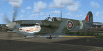
This folder contains a repaint for the Supermarine Spitfire Mk.IX by Real Air. It shows Spitfire IXc MK210 as flown by Lt.Col Gustav Lundquist of the USAAF, Test Section, Boscombe Down. He made an emergency landing on Greenland while returning to the UK from the US. The Spitfire had been testing long range tanks at Wright Field. While waiting for spare parts, a mechanic, sgt Petta asked if he could paint nose art on the aircraft. When Col Lundquist returned, this was the result. On return to Boscombe Down, the noseart was removed and hung above the bar in the officers'mess. Repaint by Jan Kees Blom, based on the paintkit by RealAir.
| Filename: | jk_realair_spitfire_mk210.zip |
| License: | Freeware |
| Added: | 11th July 2018, 16:49:57 |
| Downloads: | 93 |
| Author: | Jan Kees Blom |
| Size: | 3.51 MB |
| Category: Flight Simulator 2004 - AFCAD Files | |
| MATVA Afcads |
|
File Description:
Continuing our practice of improving airfields Microsoft have seen fit to provide little or no facilities at. Scottish VA the MATVA Group present Afcad2 files for those airfields MATVA utilise. These Afcads are designed for FS2004 default airfields only. The 21 airfields in this package are: Pyong Yang in North Korea (ZKPY), Islamabad, Pakistan (OPRN), Managua, Nicaragua (MNMG), Banjarmasin, Indonesia (WRBB), Cape Town, (FACT), Kolkatta, India (VECC), Sanya, China (ZJSY), Kunming, China (ZPPP), Macau (VMMC), Osaka, Japan (RJBB), Sapporo, Japan (RJCC), Sondestrom, Greenland (BGSF), Brasilia, Brasil (SBBR), Recife, Brasil (SBRF), Australian, Airfields Perth (YPPH), Cocos Island (YPCC) and Alice Springs (YPAS), Ulaanbaatar, Mongolia (ZMUB), Thailand airfields Bangkok, (VTBD), Chiang Mai, (VTCC) and Phuket (VTSP). enjoy!!!! www.matvagroup.co.uk
| Filename: | mafcad_3.zip |
| License: | Freeware, limited distribution |
| Added: | 21st December 2005, 13:50:32 |
| Downloads: | 5,538 |
| Author: | Louie Maclennan MATVA |
| Size: | 86 KB |
| Category: Flight Simulator 2004 - Flight Plans | |
| Hopping Round the World Adventure - Pack 8 |
|
File Description:
Can a Boeing 777-300 do that? Find out if you can in The Florida Keys. Ahhhhhhh, for the first time ever you'll notice a default AI DC3 in FS2004. Where? Havana, Cuba. Look for it before departing the gate area. With a couple of United States stops behind us, its on towards the hot destination of spring break in Cancun, Mexico. Now in Central America, we venture to an airfield with no markings or lights whatsoever. Good thing it was a daytime landing. Looking at my charts, we may have some dicey approaches upcoming for Central America. I hope the weather is above IFR conditions during our operations there. Once we complete the many legs in Central America, its back to the USA before heading up towards Canada and Greenland.
| Filename: | hrw_pack_8.zip |
| License: | Freeware |
| Added: | 27th August 2003, 19:45:25 |
| Downloads: | 4,314 |
| Author: | David Dossiere |
| Size: | 1.89 MB |
| Category: Prepar3D V1-4 - Utilities | |
| Random Flight Database 2.2.1 |
|
File Description:
Random Flight Database is a simple and easy to use application. It will allow you to randomly choose a flight according to your criteria.
A default database is already included, but also the possibility for each user to create his own database.
But it's not all, you can also extract the flights of the day for an airport, or extract flights on a full week.
Windows Only
2.2.1 :
Replace winter by summer 2019 :
Air Bucharest
Air Cote d'Ivoire
Air Greenland
My Way Airlines
Plus Ultra
Wings of Lebanon
Bug fix merging files when opening RFD
Added Flight Aware in "Extraction of scheduled flights and random choice in the list"
Add in "About" :
Website button
Button to find all my downloads
Correction Check Update Bug
Install :
Execute .exe
Contact
[email protected]
https://mikoulprostgrandprix.wixsite.com/randomflightdatabase
| Filename: | random_flight_database_376660.zip |
| License: | Freeware |
| Added: | 12th September 2019, 04:38:58 |
| Downloads: | 43 |
| Author: | mikoulprostgrandprix |
| Size: | 79.03 MB |
| Category: Flight Simulator 2004 - Flight Plans | |
| 1960 - Delivery flight of Viscount VH-RMK - Omaha to Melbourne, the long way round. |
|
File Description:
This FS2004 (FS9) flight replicates the route taken by Ansett-ANA's Viscount VH-RMK (previously Continental Airlines' N241V) when it was delivered - by an Ansett crew - from Omaha, Nebraska to Essendon airport, Melbourne.
The crew consisted of Cpt. C. Lister (in command), Cpt. D. Bull, First Officer J. Farrell, Navigator W. Kennedy and Flt. Engineer J. Howard.
The flight commenced on the morning of September 17th. 1960 and took 12 days, the route being across the continental United States to Chicago, thence to Canada, Greenland, Iceland, Scotland, United Kingdom, Italy, Greece, UAR, Pakistan, India, Thailand, Vietnam, Phillipines, Indonesia and finally Australia.
You may wonder why they took the "long way round" rather than ferry the aircraft across the Pacific route: very simply, the Viscount did not have the range required to safely transit the distances between the only refuelling points available down through the Pacific Ocean.
A ReadMe with the simple installation instructions and historical information is included.
| Filename: | vhrmk_60.zip |
| License: | Freeware |
| Added: | 7th July 2007, 22:37:15 |
| Downloads: | 832 |
| Author: | Bruce Kennewell |
| Size: | 2.09 MB |
| Category: Flight Simulator 2004 - Flight Plans | |
| Hopping Round The World Adventure - Pack 20 |
|
File Description:
My most difficult pack yet! I almost lost my bird on more than one ocassion. This HRW Adventure pack is how real-world pilots get into trouble. You might lose your plane during some critical phases of flight. Don't wreck your friend's LearJet. Things to ponder: Haven't used your de-icer yet in FS2004-you will unless you want ice buildup. Since AI pilots are bold enough to take off and land during these conditions I did the same. Everything starts out OK before it all goes bad quickly. You will run into a severe winter storm and unforgiving crosswinds and heavy winds for that matter. There is so much going on in this pack you will have little time to enjoy seeing Niagra Falls and the Statue of Liberty. Look for both once you take off. The only newbie in this pack is the iFDG 767. If this is how unforgiving winter is there is no telling what's in store once we head up next to Canada again, New Brunswick, Newfoundland, Greenland and then onto Iceland. Well if you are still in one piece come join me. 207 takeoffs/landings and 32,970 miles flown so far.
| Filename: | hrw_pack_20.zip |
| License: | Freeware |
| Added: | 17th December 2003, 00:29:52 |
| Downloads: | 3,885 |
| Author: | David Dossiere |
| Size: | 2.27 MB |
| Category: Flight Simulator 2004 - Aircraft Repaints, Textures and Modifications | |
| Air Iceland/Flugfelag Islands Bombardier Dash-8-106 (TF-JMB) |
|
Images related to this file:
File Description:
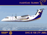
Here's another Dash-8 especially for the Icelandic simmers out there or those who prefer the challenge of simming the skies and airports of the northernmost latitudes. This is one of two (2) Dash 8-106's flown by Air Iceland (Icelandic: Flugfelag Islands) and bears registration TF-JMB. Flugfelag Islands, a subsidiary of Icelandair Group, is a regional airline with bases at Reykjavik Airport and Akureyri Airport. It operates scheduled service to destinations in Iceland and Greenland, as well as the Faroe Islands. I want to give due credit to and thank Elmar Voigt, who inspired this project and repaint and worked with me to get every detail of it as realistic as possible. Some of those details include the text 'flugfelag.is' on the bottom of the fuselage (just like the real aircraft) and a tug painted in Air Iceland/Flugfelag Islands colors with their logo on the doors. All repainted textures in this package are 32-bit with no mips for maximum quality. This is a textures only package; you must have the Dreamwings Design Dash8 Q-100 model available here at AVSIM.
| Filename: | dreamwings_dash8q-106_fxi_tf-jmb.zip |
| License: | Freeware, limited distribution |
| Added: | 29th June 2010, 02:25:57 |
| Downloads: | 1,031 |
| Author: | Jeffrey S. Bryner, Elmar Voigt, Dreamwings Design |
| Size: | 3.29 MB |
| Category: Flight Simulator X - Scenery | |
| CYFB - Iqaluit Airport - Nunavut, Canada |
|
Images related to this file:
File Description:
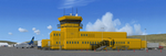
Iqaluit is the capital of Nunavut, a vast northern region that covers almost all of the Canadian North. The airport is of critical importance to the community, especially when ice makes boat travel impossible.
The scenery includes all airport buildings with custom designed and generic buildings nearby. Several typical airlines are represented, both by their flights by their facilities, including First Air, Canadian North, Air Greenland, Ken Borek Air and Keewatin. The Airbus A380 was in Iqaluit in February 2006 for flight testing in cold weather, as do other manufacturers. Airbus will also carry out the same tests for its new A350.
CYFB is also a Canadian Force base. Several units are parked in the military area, in addition to the C- 177 and his escort on ramp 2. A Twin Otter from the RCMP, and some general aviation aircrafts complement the fleet. Six ships are in the scenery: four static and two mobile (AI). Zodiacs and a balloon tourist flow into the bay. These, and the ships AI, start their movements 1100Z. The weather station launches a weather balloon regularly. Three small caribou herds are in the vicinity.
| Filename: | cyfbfsx.zip |
| License: | Freeware, limited distribution |
| Added: | 5th April 2014, 14:37:23 |
| Downloads: | 3,948 |
| Author: | Jean-Pierre Fillion, Pierre Gallant |
| Size: | 16.88 MB |
| Category: Flight Simulator 2004 - Scenery | |
| Qikiqtarjuaq CYVM (Broughton) and DEW FOX-5 in Nunavut, Canada |
|
Images related to this file:
File Description:
Qikiqtarjuaq is an airfield on the northeast coast of Baffin Island, just over 100 miles north of Pangnirtung. The airfield is the closest Canadian airfield to Greenland and is used for ferry flights from Canada to Europe for small planes, though there is normally only JetA1 fuel available. The airfield is at only 18 feet ASL next to the sea with the village to the north; it was previously (before 1998) called Broughton Island. The runway is 3,800' of 100' wide gravel and is lighted; as it is in the Northern Domestic Airspace the runway is signed as 033T-213T, using "true" bearings instead of magnetic. There is a terminal and a small maintenance building on the apron and these have been modeled specifically for this scenery. There are AI parking spots; the AI visiting aircraft are a Canadian North Dash 8 and a First Air 42-300. Qikiqtarjuaq village is just north of the airfield and has a population of around 520; it is approximately the right size and shape but no buildings were specifically modeled for the village. There is also a North Warning System site called Fox-5 to the northeast, and this too is included. You will need Ultimate Terrain Alaska Canada.
| Filename: | qikiqtarjuaq.zip |
| License: | Freeware, limited distribution |
| Added: | 14th June 2011, 02:04:26 |
| Downloads: | 542 |
| Author: | Roger Wensley |
| Size: | 1.9 MB |
| Category: Flight Simulator 2004 - Scenery | |
| Cape Dyer CWFD in Nunavut, Canada |
|
Images related to this file:
File Description:
Cape Dyer is on the southeast corner of Baffin Island, around 120 miles east of Pangnirtung at approximately N66 45 W61 30. There is a fine view north up the Davis Strait between Baffin Island and Greenland, and this is the whole reason for the airfield's existance as it was built to support the construction and operation of a DEW line radar station, which has now been updated to a North Warning System site. There are two camps; the upper camp is on the east side of the Cape and is where the radars are located, linked by a gravel road to the lower camp, which is on the west and more sheltered side of the Cape on the clifs above Sunneshine Fjord. The runway is 5,000' of 150' wide gravel, and it is lighted and at 1,320' feet ASL. Cape Dyer is now listed as abandoned in the Canada Flight Supplement. It is, however, still there and presumably is still used for access to the North Warning System equipment, which is automated and generally unmanned. The buildings were modeled for this scenery and include a hanagar large enough to accommodate a C-130. Ultimate Terrain is not required as it does not cover northern Canada.
| Filename: | cape_dyer.zip |
| License: | Freeware, limited distribution |
| Added: | 21st June 2011, 19:30:07 |
| Downloads: | 481 |
| Author: | Roger Wensley |
| Size: | 1.95 MB |
© 2001-2025 AVSIM Online
All Rights Reserved