
Where Flight Simulation Enthusiasts Gather from Around the World!
AVSIM Library - Search Results

| Category: Flight Simulator 2004 - Scenery | |
| Southern Los Angeles, California |

|
File Description:
This scenery contains ground scenery for the area of southern Los Angeles, LAX, TOA, HHR, LGB in standard FS-resolution of 4.7m/pixel.
| Filename: | lax_south2005_lr.zip |
| License: | Shareware, honor system |
| Added: | 17th August 2006, 04:05:49 |
| Downloads: | 17,312 |
| Author: | Gottfried Razek |
| Size: | 21.87 MB |
| Category: Flight Simulator 2004 - Scenery | |
| Santa Monica (SMO) High Resolution Airport Area Ground Scenery |
|
File Description:
This package contains high resolution ground scenery for the traffic pattern area of Santa Monica (SMO). Normal flight simulator scenery has a resolution of approximately 4.7 meters/pixel. That's OK at higher altitudes but leads to very blurry ground textures when flying low - e.g. in the traffic pattern. My high resolution airport area sceneries have a resolution 1.2 meters/pixel. This results in much more detail and a more realistic experience of "being there".
This scenery gives best results when combined with my "Southern-" and "Northern Los Angeles" standard resolution ground sceneries, available here:
Southern Los Angeles: http://library.avsim.net/esearch.php?CatID=fs2004scen&DLID=89921
Northern Los Angeles: http://library.avsim.net/esearch.php?CatID=fs2004scen&DLID=89911
For more information please visit: http://n330dg.batcave.net
| Filename: | Santa_Monica_SMO_High_Resolution_Airport_Area_Ground_Scenery.zip |
| License: | Freeware, limited distribution |
| Added: | 23rd August 2006, 22:08:43 |
| Downloads: | 7,964 |
| Author: | Gottfried Razek |
| Size: | 17.96 MB |
| Category: Flight Simulator 2004 - Scenery | |
| San Francisco Int. (SFO) High Res Ground Scenery |
|
File Description:
This scenery contains high resolution ground scenery for the airport of San Francisco Intl. (SFO). It makes me kind of nostalgic, because that's the area where I first successfully tried my hi-res mesh technique for FS2004. The scenery has a resolution of 1.2m/pix (4.7m/pix is FS2004-standard). Coverage is the area around SFO containing the San Bruno Mountain Park and the San Adreas Res. So it's quiet a sight! And don't forget to bring some flowers :-) The scenery gives best results when combined with with my "San Francisco" standard resolution ground scenery, which covers a much larger area at 4.7m/pix and matches perfectly in color and everything...
Won't work in FSX. For FSX please wait for the upcoming FSX-version of this scenery.
| Filename: | sfo2006_hr.zip |
| License: | Freeware, limited distribution |
| Added: | 27th November 2006, 10:58:19 |
| Downloads: | 16,783 |
| Author: | Gottfried Razek |
| Size: | 41.8 MB |
| Category: Flight Simulator 2004 - Scenery | |
| Aspen (KASE), Colorado, Photo-Scenery (FS9 & FSX) |
|
Images related to this file:
File Description:
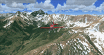
There sure is more than one reason to go to Aspen and this is sure another must-have of my Colorado sceneries. If you're coming IFR there's a couple of very demanding approach procedures. From a LOC/DME to several visual approaches there's everything your heart might desire. Due to the steep and high surrounding terrain these are quiet some hair raisers (see www.airnav.com/airport/KASE). If you're coming VFR then the traffic pattern altitude is 9.005 ft for light aircraft (vs. 9.505 for aircraft 12.500 lbs or more). Weather and wind permitting, RW15 is preferred for all landings (left pattern). RW33 has a right pattern and is preferred for all takeoffs. You even need a written permission to depart RW15. When departing VFR make a right turn to a heading of 360 degrees ASAP for noise abatement and hold this heading for at least 2 miles from the field. And don't forget to enjoy the impressive mountain scenery with two 14ers: Snowmass Mtn. and Castle Pk. to the southwest. This scenery brings you another 3.500 sq km of beautiful Colorado in 4.7m/pix quality. High resolution versions of this scenery for FS9 and FSX (much sharper, but larger and multiple downloads) are available at www.blueskyscenery.com/GNB_South2West2.html . The screenies are taken from the high-res versions, so expect this version to be slightly more blurry. YourDonation@Work: Dedicated to Mark, Markus and Yves.
| Filename: | gnb_south2west2_2010_lr.zip |
| License: | Freeware, limited distribution |
| Added: | 30th January 2010, 17:04:55 |
| Downloads: | 3,547 |
| Author: | Gottfried Razek - blueskyscenery.com |
| Size: | 92.5 MB |
| Category: Flight Simulator 2004 - Scenery | |
| Leadville (KLXV), Mt. Elbert, Colorado, Photo-Scenery (FS9 & FSX) |
|
Images related to this file:
File Description:
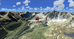
Extends my Aspen scenery to the east and contains more gorgeous Continental Divide area of the Rocky Mountains. Covers Leadville Lake County Airport (KLXV), which is the highest airport in North America (9.927 ft) and Mt. Elbert, which is the highest peak in the Rocky Mountains (14.443 ft). Aircraft performance deteriorates
with altitude, so many companies use the Leadville Airport as a base for high altitude performance testing. This scenery brings you another 3.500 sq km of beautiful Colorado in 4.7m/pix quality.
High resolution versions of this scenery for FS9 and FSX (much sharper, but larger and multiple downloads) are available at www.blueskyscenery.com/GNB_South2West.html . The screenies are taken from the high-res versions, so expect this version to be slightly more blurry. YourDonation@Work: Dedicated to Daniel, Art and Rotui.
| Filename: | gnb_south2west_2010_lr.zip |
| License: | Freeware |
| Added: | 1st February 2010, 19:06:58 |
| Downloads: | 1,695 |
| Author: | Gottfried Razek - blueskyscenery.com |
| Size: | 94.68 MB |
| Category: Flight Simulator 2004 - Scenery | |
| Colorado Springs North, Colorado, Photo-Scenery (FS9 & FSX) |
|
Images related to this file:
File Description:
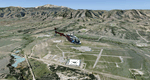
This region covers the area between Denver and Colorado Springs. It extends my Denver scenery to the south.
Just north of Colorado Springs you can see the widespread United States Air Force Academy which, with it's
many buildings, covers a huge area of 18.000 acres. The Academy Airfield (KAFF) which lays in the northeastern
corner of the area is used for training cadets in airmanship courses, including parachute training,
soaring and powered flight.
High resolution versions of this scenery for FS9 and FSX (much sharper, but larger and multiple downloads)
are available at www.blueskyscenery.com/GNB_South2East.html . The screenies are taken from the high-res versions,
so expect this version to be slightly more blurry. YourDonation@Work: Dedicated to Robin and Raymond.
| Filename: | gnb_south2east_2010_lr.zip |
| License: | Freeware, limited distribution |
| Added: | 3rd February 2010, 02:09:59 |
| Downloads: | 2,173 |
| Author: | Gottfried Razek - blueskyscenery.com |
| Size: | 96.92 MB |
| Category: Flight Simulator 2004 - Scenery | |
| Mesa Verde National Park, Cortez (KCEZ), Colorado, Photo-Scenery (FS9 & FSX) |
|
Images related to this file:
File Description:
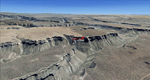
Mesa Verde National Park is famed for its numerous ruins of cliff dwellings built in the 12th century by ancient Pueblo people called Anasazi. Cliff dwellings are highly defensible stone villages situated under alcoves (rock overhangs) along the canyon walls. The largest cliff dwelling in the park is Cliff Palace, which is the largest cliff dwelling in North America. Cliff Palace contained 150 rooms and housed approximately 100 people. Unfortunately you won't see the cliff dwellings from the air, because they are under the cliffs but you will see everything else like all roads, trails and facilities. Very little is known about the Anasazis and the reason for their sudden departure at the end of the 13th century remains a mystery. Theories range from crop failures due to droughts to an intrusion of foreign tribes from the North. The name "Mesa Verde" stems from Spanish explorers seeking for a route from Sante Fe to California. They named the region Mesa Verde (spanish for green table) because of its high, tree-covered plateaus. High resolution versions of this scenery for FS9 and FSX (much sharper, but larger and multiple downloads)
are available at www.blueskyscenery.com/GNB_West2.html . The screenies are taken from the high-res versions, so expect this version to be slightly more blurry. Thanks to Joop Mak for providing custom AFCADs that correct airport layouts so that they align with the photo-textures! They are available at www.blueskyscenery.com/AFCADs.html . YourDonation@Work: Dedicated to David.
| Filename: | tex_southwest_2010_lr.zip |
| License: | Freeware, limited distribution |
| Added: | 1st May 2010, 03:55:31 |
| Downloads: | 1,456 |
| Author: | Gottfried Razek - blueskyscenery.com |
| Size: | 92.87 MB |
| Category: Flight Simulator 2004 - Scenery | |
| Page (KPGA), Lake Powell West, Utah/Arizona, Photo-Scenery (FS9 & FSX) |
|
Images related to this file:
File Description:
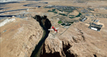
This scenery covers the western part of Lake Powell, the city of Page (KPGA), the Vermillion Cliffs, Glenn Canyon just south of Glenn Canyon Dam, the northern part of Marble Canyon, Paria Canyon, Cockscomb, etc, etc. Spectacular! To explore the scenery depart from Page Municipal Airport (KPGA). High resolution versions of this scenery for FS9 and FSX (much sharper, but larger and multiple downloads) are available at www.blueskyscenery.com/CNY_South3West3.html . The screenies are taken from the high-res versions, so expect this version to be slightly more blurry. YourDonation@Work: Dedicated to William, Veit and Michele.
| Filename: | cny_south3west3_2010_lr.zip |
| License: | Freeware, limited distribution |
| Added: | 3rd March 2010, 21:26:32 |
| Downloads: | 1,805 |
| Author: | Gottfried Razek - blueskyscenery.com |
| Size: | 92.41 MB |
| Category: Flight Simulator 2004 - Scenery | |
| Grand Staircase Escalante National Monument/East, Escalante (1L7), Utah, Photo-Scenery (FS9 & FSX) |
|
Images related to this file:
File Description:
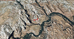
This scenery contains the eastern part of the Grand Staircase Escalante National Monument. It extends from the town of Escalante down south where it connects with the Page/Lake Powell scenery. Contains the upper part of wonderful Escalante Canyon. To explore the scenery depart from Escalante Airport (1L7). Thanks to Joop Mak for providing a custom AFCAD that corrects the airport layout so that it matches with the photo-textures! High resolution versions of this scenery for FS9 and FSX (much sharper, but larger and multiple downloads) are available at www.blueskyscenery.com/CNY_South2West3.html . The screenies are taken from the high-res versions, so expect this version to be slightly more blurry. YourDonation@Work: Dedicated to Jay, Donald and Franz
| Filename: | cny_south2west3_2010_lr.zip |
| License: | Freeware, limited distribution |
| Added: | 4th March 2010, 22:44:30 |
| Downloads: | 1,476 |
| Author: | Gottfried Razek - blueskyscenery.com |
| Size: | 96.2 MB |
| Category: Flight Simulator 2004 - Scenery | |
| Bryce Canyon National Park (KBCE), Utah, Photo-Scenery |
|
Images related to this file:
File Description:
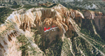
Bryce Canyon National Park (KBCE), Utah, Photo-Scenery (FS9 & FSX)
Despite its name, Bryce Canyon is not actually a canyon that was formed by a river, but rather a giant natural cliff shaped through erosion by wind, water, and ice. Bryce is distinctive due to its geological formations, delicate and colorful pinnacles called hoodoos that are up to 200ft high. The bizarre forms and red, orange and white colors of the rocks provide spectacular views. Unfortunately the hoodoos are too small for the elevation mesh in flight simulator. But you can enjoy the colors and shape of the cliffs. The cliffs in main region of the park, just south of the airport are partly covered
by snow. But on the southern and western part of the plateau you can enjoy them free of snow. Bryce Canyon is named after the Mormon pioneer Ebenezer Bryce who settled in this area in the 1850s. It was designated as a national park in 1928.
Bryce Canyon Airport (KBCE) just handles small aircraft on a daily basis. But is was actually built to handle larger aircraft in case of emergency. And so on Oct.6th 2000 an American Airlines MD-82 from Denver to Los Angeles made a successful emergency landing after reporting smoke in the cockpit and a loss of cabin pressure.
High resolution versions of this scenery for FS9 and FSX (much sharper, but larger and multiple downloads)are available at www.blueskyscenery.com/CNY_South2West4.html . The screenies are taken from the high-res versions, so expect this version to be slightly more blurry. Thanks to Joop Mak for providing a custom AFCADs that correct airport layouts so that they align with the photo-textures! They are available here: www.blueskyscenery.com/AFCADs.html . YourDonation@Work: Dedicated to Michael, Pat and Keith.
| Filename: | cny_south2west4_2010_lr.zip |
| License: | Freeware, limited distribution |
| Added: | 7th March 2010, 11:17:56 |
| Downloads: | 2,191 |
| Author: | Gottfried Razek, blueskyscenery.com |
| Size: | 96.35 MB |
© 2001-2025 AVSIM Online
All Rights Reserved