
Where Flight Simulation Enthusiasts Gather from Around the World!
AVSIM Library - Search Results

| Category: Flight Simulator X - Scenery | |
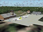
| Marchwood Sea Mounting Centre & Power Station |

|
File Description:
Marchwood Sea Mounting Centre & Power Station Scenery.
Had a few hours over the Christmas period to have a go at FSX secenery design. Know it's not perfect but using a few free programs, knocked up a Marchwood scene to try and improve the look of VFR Photographic Scenery in the area.
The programs I used as follows:-
Google Earth Pro (to take overhead screen shots of area)
ModelconverterX (to import Sketchup .skp file and convert to BGL
Sketchup Make (to model buildings and export .skp to .dae files)
Microsoft Paint (save copy of screen shot)
GIMP2 (to enhance image & cut / blend image to import to Sketchup)
My thanks to the people who provide these tools especially Arno and the people behind MCX.
The ships I converted from ones provided on the free Sketchup 3D Warehouse, my thanks to them.
Install: Copy the Final Marchwood & MW Power Station Folders to your FSX Addon scenery folder.
Do that for the HMS Trio & Husband Shore Folders also if you think it may improve the scenery. It did using my set up.
Make sure you have the fx_SmokeStack2.fx effect in your Effects folder. If not copy the file into the folder.
Install all as normal using the FSX Add Scenery facility.
Provided as freeware. Not to be distributed by anyone for gain.
Hope you like the scenery and hope it dosent affect frame rates too much.
ijm1959... ([email protected])
| Filename: | Marchwood_Sea_Mounting_Centre__Power_Station.zip |
| License: | Freeware |
| Added: | 7th January 2018, 16:59:11 |
| Downloads: | 165 |
| Author: | Ian McAdam |
| Size: | 9.9 MB |
| Category: Flight Simulator 2004 - Scenery | |
| VAOZ Nashik/Ozar, India |
|
File Description:
Googly scenery for Ozar, a small domestic airport located in Nashik (or
Nasik), 111 miles from Mumbai (Bombay). Nashik is a fast-expanding city in
the Maharashtra state in the Western Ghats located on the western edge of the Deccan
peninsula and is known as the Wine Capital of India or Grape City.
Owing to its close proximity to Mumbai, the airport has not proved popular as
the journey by taxi, bus or rail is not much greater after taking into account
check-in times etc. Air Deccan recently withdrew all flights from Ozar and as
far as I can establish the only airline now serving Ozar is Jagson Airlines,
using Dornier 228 turboprops. There is also a military presence at the east
end of the airport.
Flight Simulator 2004 has only provided a runway at this airport and this scenery
seeks to redress the situation so that you and your "AI" traffic can use the
airport.
The scenery does not purport to be ultra-accurate. Based on high quality
satellite imagery from Google Earth, the layout is proportionally correct but the
added airport features, such as buildings, are built from default Microsoft objects
and add-on libraries so will not look exactly like the real thing.
You are not obliged to download and install any additional scenery libraries,
but to enjoy this scenery in its entirety, you may wish to. It will work fine,
with or without.
| Filename: | VAOZ_NashikOzar_India.zip |
| License: | Freeware |
| Added: | 22nd April 2008, 07:55:32 |
| Downloads: | 737 |
| Author: | John Hinson |
| Size: | 118.11 KB |
| Category: Flight Simulator X - AFCAD Files | |
| Cross Keys Airport (17N), NJ |
|
File Description:
Located 01 miles S of Cross Keys, New Jersey on 280 acres of land, Cross Keys Airport is a small General Aviation field privately owned by Cross Keys Airport Inc. In addition to servicing GA flights, the airport also hosts a paintball field and a sky diving operation to the north of the field. For this reason, all aircraft must remain south of the runway at all times. Any aircraft with a wingspan larger than 40 feet will need to park in the turf area west of the main apron - smaller GA aircraft can pick a spot from any of the open tiedown areas. 100LL (Blue) Fuel is available by stopping next to the fuel tank on the main apron. Although it doesn't exist in real life, a patch of concrete to the west of the main apron made for a good helipad, so I included one. It is not lit at night. Trees in the surrounding forest are summer trees ONLY.
Scenery constructed with use of Google Maps images, and vague recollection by the author who went sky diving there once.
This scenery is meant to be used in conjunction with MegaScenery Earth New Jersey/Delaware 004. It is not required, but apron use is minimized to allow satellite scenery to show through as much as possible, and objects are placed based on the MSE textures - lack of it may make scenery look out of place.
| Filename: | Cross_Keys_Airport_17N_NJ.zip |
| License: | Freeware |
| Added: | 7th October 2010, 03:27:53 |
| Downloads: | 246 |
| Author: | Drew Sikora |
| Size: | 719.13 KB |
| Category: Flight Simulator 2004 - Scenery | |
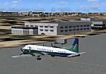
| EVVA Ventspils International, Latvia |
|
Images related to this file:
File Description:
Googly scenery for Ventspils International - Latvia's third largest commercial airport
(try not to laugh!) although no facilities other than a runway are provided in Flight
Simulator 2004. These scenery files add taxiways, aprons, buildings and other airport
features, so that you and your "AI" traffic can land, taxi, park and take off in a
realistic manner.
The airport serves the city of Ventspils in northwest Latvia and opened as recently
as 1975. Owing to changes in the political situation, operations ceased in 1983 but
it re-opened in 2000. At present, it is unclear which operators serve the airport
- Air Baltic is the claimed contender but there is no evidence in their advertised
schedules. It is believed that occasional flights are operated to St Petersburg and
Moscow by Russian operators but information is hard to come by. Nevertheless, the
airport's own web site (http://www.airport.ventspils.lv/) has figures showing the
increasing numbers of passengers passing through the airport, so something must
call here! The airport also sees a respectable amount of General Aviation activity
and AVGAS has recently been made available.
The scenery does not purport to be ultra-accurate. Based on high-detail satellite
imagery from Google Earth, the layout is proportionally correct but the added
airport features, such as buildings, are built from default Microsoft objects
and add-on libraries so will not look like the real thing. [File re-uploaded at request of AVSIM]
| Filename: | EVVA_Ventspils_International_Latvia.zip |
| License: | Freeware |
| Added: | 15th June 2010, 00:59:50 |
| Downloads: | 1,596 |
| Author: | John Hinson |
| Size: | 89.79 KB |
| Category: Flight Simulator 2004 - Scenery | |
| HCMM - Mogadishu International Airport, Mogadishu/Petrella, Somalia |
|
Images related to this file:
File Description:
Googly scenery for HCMM Mogadishu/Petrella, the capital airport of Somalia.
Astonishingly, in Flight Simulator 2004 this international airport is depicted as little
more than a runway! Whilst in the real world the airport can hardly be
described as busy, it is served by the country's sole airline - Jubba
Airways, with their wonderful Ilyushin IL-18, and many African and Eastern
European operators call by with cargo flights. In fact, the vast proportion of
the aircraft seen here are Russian-built.
These scenery files add aprons, taxiways, buildings and other airport features to Flight Simulator's limited representation and allow "AI" traffic to land, taxi, park and take off in a realistic manner. But do watch out for cars on the runway and taxiways as they
appear to be regularly used as a by-pass to the perils of driving through the city!
The scenery does not purport to be ultra-accurate. Based on high-detail satellite
imagery from Google Earth, the layout is proportionally correct but the added
airport features, such as buildings, are built from default Microsoft objects
and add-on libraries so will not look exactly like the real thing.
You are not obliged to download and install any additional scenery libraries,
but to enjoy this scenery in its entirety, you may wish to. It will work fine,
with or without. [File re-uploaded at request of AVSIM]
| Filename: | HCMM__Mogadishu_International_Airport_MogadishuPet.zip |
| License: | Freeware |
| Added: | 28th May 2010, 20:46:31 |
| Downloads: | 2,790 |
| Author: | John Hinson |
| Size: | 61.51 KB |
| Category: Flight Simulator X - Scenery | |
| Navy Yard City Bremerton, Washington |
|
Images related to this file:
File Description:
This scenery updates the area around Bremerton, Washington, Mainly the Sinclair Inlet where Navy Yard city is located. This is a huge Naval yard which by default in FSX there isn't much there but a carrier. The update adds all the carriers, battleship, destroyers, other large and fishing/sport boats along with many docks, piers, marinas and many other objects. These objects were placed using aerial shots from Google Earth for proper placement. Though the placement is near perfect the objects of course are FSX 3D objects. The Subs? There aren't any subs in the FSX object library so I used "Ron Jeffers" ron_ez_maritime.bgl for the battelship, destroyers, subs and a riverboat. special thanks to "ron". The scenery also includes a fictitous Naval Yard Helo Base. There is a family inspiration for this location, please read the text files. Also included is the ship "USS Turner Joy", not a custom made ship but a ship from the default library to indicate where this "museum" ship is located. The atempt here was to give the area the Naval look and feel as you fly over. both West and East shores of Sinclair Inlet were updated with many objects. Everything is included in this download even the AF2 file for the start point at BNYP, the Naval helo base. Please enjoy this and visit the USS Turner Joy, it has daily tours. By Savageagle
| Filename: | Navy_Yard_City_Bremerton_Washington.zip |
| License: | Freeware |
| Added: | 16th August 2011, 05:48:51 |
| Downloads: | 1,588 |
| Author: | Tim Durham |
| Size: | 5.83 MB |
| Category: Flight Simulator X - Scenery | |
| Tindari Geographic Coordinates N 38.08.27 E 15.02.48.Important VFR reference point for planes coming from Palermo and heading to Reggio Calabria |
|
File Description:
I wanted to realize the scenery of the sanctuary of Maria Santissima of Tindari village of Patti, in the province of Messina. It rises on the summit of the homonymous hill and overlooks Marinello's ponds in the homonymous nature reserve. Important VFR reference point for planes coming from Palermo and heading to Reggio Calabria. Geographic Coordinates N 38.08.27 E 15.02.48. For more information on the site search on google. In the Package you will also find instructions for installing the scenery.
| Filename: | Tindari_Geographic_Coordinates_N_380827_E_150248Im.zip |
| License: | Freeware |
| Added: | 24th August 2017, 05:08:31 |
| Downloads: | 255 |
| Author: | Pasquale Marrulli |
| Size: | 1.6 KB |
| Category: Flight Simulator X - AFCAD Files | |
| Kota Kinabalu International Airport - WBKK - Sabah, Malaysia |
|
File Description:
The FSX stock WBKK is updated to include the new Terminal 1, old Terminal 2 (with Sabah Flying Club buildings), etc. using the freeware Airport Design Editor X (v1.47.07) with the FSX generic buildings and other object libraries.
The surrounding scenery buildings are created based on photos taken from Google Maps and other sites about Kota Kinabalu International Airport (KKIA). The runway is extended along with 17 larger parkings (with jetways) based on Wikipidea and the web photos.
| Filename: | Kota_Kinabalu_International_Airport__WBKK__Sabah_M.zip |
| License: | Freeware |
| Added: | 29th May 2010, 09:53:56 |
| Downloads: | 677 |
| Author: | Harry Sung |
| Size: | 7.19 KB |
| Category: Flight Simulator 2004 - AFCAD Files | |
| LEMR - "Aerodromo de La Morgal", Oviedo (Asturias, Spain) |
|
File Description:
This a basic AFCAD for LEMR, enhanced with ADE9 in order to make it less sad than the default one, and a few more similar to the Google and Panoramio photos. In version 3, added one apron with parking for GA and four helipads, hangars, fuel station, windsocks and a fragment of the ancient transversal runway, still in use as general purpose apron. I hope with this file your GA AI Traffic can have place for taking off, landing and sleeping.
| Filename: | LEMR__Aerodromo_de_La_Morgal_Oviedo_Asturias_Spain.zip |
| License: | Freeware, limited distribution |
| Added: | 12th July 2011, 02:23:01 |
| Downloads: | 181 |
| Author: | Felix Fernandez de Castro |
| Size: | 2.82 KB |
| Category: Flight Simulator 2004 - Scenery | |
| SBUG - Uruguaiana Airport Brazil |
|
File Description:
A total remake of the default FS2004 airport. This scenery is designed to be used with the default FS2004 scenery and may work with others, but not tested. I tried to make the layout as exact as possible as the real airport using Google Maps and ADE9. The buildings were designed using Instant Object Studio. EZ Scenery was used to place the more common elements like vehicles, trees, fences and lights, etc. Airport Design Editor was used for the layout of the airport.
| Filename: | SBUG__Uruguaiana_Airport_Brazil.zip |
| License: | Freeware |
| Added: | 3rd September 2017, 07:19:33 |
| Downloads: | 621 |
| Author: | Johnny Alford |
| Size: | 23.1 MB |
© 2001-2026 AVSIM Online
All Rights Reserved
Privacy Policy |