
Where Flight Simulation Enthusiasts Gather from Around the World!
AVSIM Library - Search Results

| Category: Flight Simulator X - Scenery | |
| Joint Base Mc Guire Dix Lakehurst Airport (KWRI) |

|
File Description:
View the ReadMe file for details. Scenery constructed with use of satellite images/streetview/aerial photos - the author has not been there in person. This scenery is meant to be used in conjunction with MegaScenery Earth New Jersey/Delaware 002. It is not required, but apron use is minimized to allow satellite scenery to show through as much as possible, and objects are placed based on the MSE textures - lack of it may make scenery look out of place.
| Filename: | Joint_Base_Mc_Guire_Dix_Lakehurst_Airport_KWRI.zip |
| License: | Freeware |
| Added: | 4th June 2012, 01:18:43 |
| Downloads: | 1,025 |
| Author: | Drew Sikora |
| Size: | 24.06 MB |
| Category: Flight Simulator X - AFCAD Files | |
| Fla-Net Airport (0NJ5), NJ |
|
File Description:
This another weird airport entry in the FSX database. The real 0NJ5 is the Meadowlands Sports Complex Heliport #2, and this just shows up as a random turf strip up near Netcong/Flanders in northern NJ. I could not find any specific information regarding the airport online, and while it does appear to once harbour the room and terrain for a grass strip, it's largely overgrown, even in the current MegaScenery Earth textures. So I've removed the strip entirely. There is still a start at the northwest end of where the strip used to be if you want to travel there, but that's it.
Scenery constructed with use of satellite images/streetview, the author has not been there in person.
This scenery is meant to be used in conjunction with MegaScenery Earth New York 005. It is not required, but apron use is minimized to allow satellite scenery to show through as much as possible, and objects are placed based on the MSE textures - lack of it may make scenery look out of place.
| Filename: | FlaNet_Airport_0NJ5_NJ.zip |
| License: | Freeware |
| Added: | 21st October 2010, 23:23:44 |
| Downloads: | 188 |
| Author: | Drew Sikora |
| Size: | 199.2 KB |
| Category: Flight Simulator X - AFCAD Files | |
| A redesign of RPMT - Marcos and RPMQ - Imelda Romualdez Marcos (Mati Community Airport), Philippines to aid FSEconomy users |
|
File Description:
This is a redesign of RPMT - Marcos and RPMQ - Imelda Romualdez Marcos (Mati Community Airport), Philippines. This places RPMQ in the correct location and adds a fictional RPMT. This will aid FSEconomy users where one airport (RPMT) was entirely missing. Google Maps has been used to provide the correct (as physically possible within FSX and ADE) position, size and type of runway, aprons and buildings. The immediate surrounding scenery has been included. ADE used to compile the design.
| Filename: | A_redesign_of_RPMT__Marcos_and_RPMQ__Imelda_Romual.zip |
| License: | Freeware |
| Added: | 11th October 2017, 00:59:22 |
| Downloads: | 165 |
| Author: | Matthew Ward |
| Size: | 121 KB |
| Category: Flight Simulator X - AFCAD Files | |
| LEPA - Son San Juan - Mallorca Intl. Airport |
|
File Description:
This file includes a new Afcad File for FSX default Scenery- LEPA Son San Juan Intl. Airport.
Features:
- Ground structure was modified by Pics of Google Maps- some Taxiway´s have another structure now
- I added lot´s of ground service objects and some cargo buildings
- Air Berlin gate positions changed
- Lights were added for a realer Airport feeling
- ATTENTION: Please download the following file by Jim Dhaenens from avsim.com: 'fsx_lts.zip'
| Filename: | LEPA__Son_San_Juan__Mallorca_Intl_Airport.zip |
| License: | Freeware |
| Added: | 3rd April 2009, 19:22:38 |
| Downloads: | 1,348 |
| Author: | Dean Hammer |
| Size: | 20.25 KB |
| Category: Flight Simulator X - Scenery | |
| Isola San Giulio |
|
File Description:
This scenario a small Italy island of San Giulio on Lake Orta, near the famous Lake Maggiore its coordinates are N45.47.70 E8.23.86.
For the best information you can search Google Isola San Giulio.
In the package you will find the file Isola_San_Giulio.bgl that will be placed at the addon scenery folder and subfolder scenery automatically when FSX scenery you will find it in the scenario.
Good flight at all. We accept criticism and advice [email protected]
| Filename: | Isola_San_Giulio.zip |
| License: | Freeware |
| Added: | 3rd July 2015, 16:49:13 |
| Downloads: | 626 |
| Author: | Pasquale Marrulli |
| Size: | 35.02 KB |
| Category: Flight Simulator 2004 - Scenery | |
| Sucre, Bolivia - SLAL - Alcantari Int'l Airport - Patch fix updated |
|
File Description:
7 years ago, I created that time was no detailed enough. I have a Navigraph chart and saw Google Images updated. I found out the VOR location wasn't correct. I fixed and moved the correct location. Sorry, some pilot simmers get confused about location offset too short to the runway. My bad. LOL Now, it's corrected. I removed the grass poly the airport doesn't have grass surrounding it. I put VTPP ply. It looks good for now.
| Filename: | Sucre_Bolivia__SLAL__Alcantari_Intl_Airport__Patch.zip |
| License: | Freeware |
| Added: | 3rd December 2022, 13:10:51 |
| Downloads: | 151 |
| Author: | Stuart John Gilbert II |
| Size: | 4.93 MB |
| Category: Flight Simulator X - Scenery | |
| OMDB - Dubai Intl Airport - Dubai, UAE |
|
Images related to this file:
File Description:
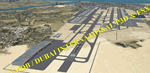
OMDB - GPS-accurate scenery based om Google maps and the FlyTampa base AFCAD (default FSX/P3D AFCAD). Every Runway, Gate and taxiway is right on the actual spot with a very small error margin.
Two types of Jetway structures used for Terminals 1 & 3, and are made by Victor Nauta. The new Concourse-D terminal for airlines other than Emirates is now added, with a basic terminal building design using Google Sketchup for better visuals.
WHAT'S NEW:
- The new Concourse-D terminal east of the existing Terminal 1. Terminal replaces the old Emirates Sky Cargo terminal, and servers all other visiting airlines.
- Apron Q used by FlyDubai is added.
- Extra runway rapid exits added.
- Extra parking gates in the C apron according to the latest charts.
- Extra Taxiways connecting to the runways according to the charts.
- Ground marking for Gates and taxiways! (A, B, C, D and F aprons)
- Aprons G and S are added according to the latest Airport layout and charts.
| Filename: | OMDB__Dubai_Intl_Airport__Dubai_UAE.zip |
| License: | Freeware, limited distribution |
| Added: | 25th July 2016, 20:17:21 |
| Downloads: | 10,965 |
| Author: | Ahmed Abdessalam |
| Size: | 4.16 MB |
| Category: Flight Simulator X - Aircraft Repaints, Textures and Modifications | |
| Cessna O-1A Birddog, Canadian Army, #723 |
|
Images related to this file:
File Description:
This repaint is intended for the SibWings payware Cessna O-1 Birddog for FSX. These textures are updated to version 1.2 of the aircraft.
The aircraft depicted served with the Canadian Army in West Germany in the mid to late '60s. Colour-scheme worn is the wraparound disruptive camouflage consisting of dark green/dark earth.
In addition to the diffuse textures, I also created new external bump maps using the method described in the FSX SDK. Instrument panel textures are also custom made.
| Filename: | Cessna_O1A_Birddog_Canadian_Army_723.zip |
| License: | Freeware |
| Added: | 3rd September 2010, 02:08:41 |
| Downloads: | 182 |
| Author: | Dag Roger Stangeland |
| Size: | 4.4 MB |
| Category: Flight Simulator X - Scenery | |
| Albany International Airport (KALB) Albany, New York |
|
Images related to this file:
File Description:
This airport was made using Airport Design Editor, Google Sketchup, and Instant Scenery 2. Albany International Airport, Is an airport located near Albany, New York. The airport has scheduled airline flights. Almost all of the buildings are custom made with photo textures to make it closer to real life. At the main terminal, I added more gates and put moving jetways. The gates have assigned parking codes. There is a parking lot next to the terminal full of cars. I put the airport access road in between the parking lot and the terminal. At the southwest ramp, I put hangars and some you can taxi inside of. If you choose to start off from the southwest DOCK gate, You will start off inside the Million Air Aviation FBO. I also put static aircraft on the ramp too. To the northwest, I put the New York Police hangar. You can start off inside this hangar by choosing the Northwest DOCK gate. Taxiing into or starting off inside a hangar will not cause a crash unless you touch the sides. To the Northeast, I put the cargo terminal with trucks. At the cargo section, I put three FedEx Cessna Caravans. I also put the control tower and the buildings. Tower views are from the roof of the control tower. To the southeast, I put small hangars and the Air National Guard Section with UH-60 helicopters. I extended runway 1/19 to the correct length of 8,500 feet. I also put red, blue, green, and purple Cessna 172s in different places around the airport. There will be more objects if your scenery complexity is set to normal (such as jetways, aircraft, and vehicles). This was all made based on Google Earth Imagery and Bing Maps. There are no night textures for the buildings. This will be added in a future version. An installer program is included to install the airport for you. There will be more versions of this that include night textures and static business jets. This is for Flight Simulator X only. By Tyler Lawrence.
| Filename: | Albany_International_Airport_KALB_Albany_New_York.zip |
| License: | Freeware |
| Added: | 2nd June 2012, 08:14:12 |
| Downloads: | 4,342 |
| Author: | Tyler Lawrence |
| Size: | 47.69 MB |
| Category: Orbiter - Spaceships | |
| Explorer 1 Add-on for Orbiter |
|
File Description:
Explorer 1 was the first satellite launched by the United States when it was sent into space on January 31, 1958. Following the launch of the Soviet Union's Sputnik 1 on October 4, 1957, the U.S. Army Ballistic Missile Agency was directed to launch a satellite using its Jupiter C rocket developed under the direction of Dr. Wernher von Braun. The Jet Propulsion Laboratory received the assignment to design, build and operate the artificial satellite that would serve as the rocket's payload. JPL completed this job in less than three months.
The primary science instrument on Explorer 1 was a cosmic ray detector designed to measure the radiation environment in Earth orbit. Once in space this experiment, provided by Dr. James Van Allen of the State University of Iowa, revealed a much lower cosmic ray count than expected. Van Allen theorized that the instrument may have been saturated by very strong radiation from a belt of charged particles trapped in space by Earth's magnetic field. The existence of these radiation belts was confirmed by another U.S. satellite launched two months later, and they became known as the Van Allen Belts in honor of their discoverer.
Explorer 1 revolved around Earth in a looping orbit that took it as close as 354 kilometers (220 miles) to Earth and as far as 2,515 kilometers (1,563 miles). It made one orbit every 114.8 minutes, or a total of 12.54 orbits per day. The satellite itself was 203 centimeters (80 inches) long and 15.9 centimeters (6.25 inches) in diameter. Explorer 1 made its final transmission on May 23, 1958. It entered Earth's atmosphere and burned up on March 31, 1970, after more than 58,000 orbits. The satellite weighed 14 kilograms (30.8 pounds).
| Filename: | Explorer_1_Addon_for_Orbiter.zip |
| License: | Freeware |
| Added: | 27th September 2004, 16:24:14 |
| Downloads: | 1,258 |
| Author: | Jim Williams |
| Size: | 565.57 KB |
© 2001-2026 AVSIM Online
All Rights Reserved
Privacy Policy |