
Where Flight Simulation Enthusiasts Gather from Around the World!
AVSIM Library - Search Results

| Category: Flight Simulator 2002 - Aircraft Repaints, Textures and Modifications | |
| Vans DC-9-32(freeware version) Legend Airlines |

|
File Description:
FS2002 Vans DC-9-32(freeware version) Legend Airlines
Legend Airlines was a Full Service Low Cost Aircarrier that started from Dallas Love Field,on April 5th,2000.Flights were non-stops to Los Angeles,Las Vegas,& Washington Dulles.And then added service to New York (LaGuardia) on Sept.6th,2000.Despite the fact the LEGEND was making a nice profit,The events of 9-11 saw to this carriers demise,as well as several other air carriers.Legends DC-9's were literaly Luxury Liners.Configured for 56 seats instead of the normal 3-2 102/115 seating,with plush Leather seats with an unheard of 46" seat pitch!.There were also Satellite TV's on each seat back as well as a Laptop computer port at each seat!!.
This DC-9 has its roots with Texas International Airlines and Continental,and then the storage facility in the desert.The N12508 Reg.# was later changed to N920LG.
This is part 4 in my Lost Airlines Liveries.
Enjoy!!
| Filename: | Vans_DC932freeware_version_Legend_Airlines.zip |
| License: | Freeware |
| Added: | 5th March 2005, 22:20:05 |
| Downloads: | 192 |
| Author: | Vans - Joe DeGregorio |
| Size: | 1.02 MB |
| Category: Flight Simulator X - Scenery | |
| Lost River ASU Observatories |
|
Images related to this file:
File Description:
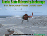
This is a fictitous scenery of the Alaska State University operated North-Western observatories.
It is located near LSR_Lost River and AK45_Lost River_2 on the Western coast of Alaska.
LSR, AK45 and KPC_Port Clarence have been upgraded with hangers and various objects.
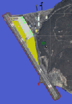
LSR, AK45 and the (2) mountain top observatories have been upgraded with helipads along with various ground vehicles including snocats, aircraft, misc buildings and hangers. The main observatory complex has a main rooftop pad and a heli-tower. These helipads were designed for heli practice. some are on the ground and others are a bit more challenging.
There is a map included which shows the locations of the observatory complexes in relation to the airports. There is also a small research facility located to the east which is indicated on the map. This fictional scenery was design with default FSX 3D objects and (1) addon library, fa_ez-arctic_set by Finney Air, Robert Finnegan.
| Filename: | Lost_River_ASU_Observatories.zip |
| License: | Freeware |
| Added: | 11th November 2009, 19:11:39 |
| Downloads: | 557 |
| Author: | Tim Durham |
| Size: | 3.41 MB |
| Category: Flight Simulator 2004 - Scenery | |
| KSUU - Travis AFB - Fairfield, CA - USA |
|
Images related to this file:
File Description:

This is an updated version of this scenery to correct texturing errors. My thanks to the the good folks on the MAIW forums for catching and correcting this error. Situated in the San Francisco Bay Area and known as the "Gateway to the Pacific", Travis Air Force Base handles more cargo and passenger traffic through its airport than any other military air terminal in the United States. Originally laid out as a SAC base for long range bombers, the original hangar line and facilities for B-36 and B-52 aircraft have been largely rebuilt over the years to accommodate the current cargo operations of the 60th Air Mobility Wing (host at Travis). The 60th supports and deploys both the C-5 Galaxy and C-17 Globemaster as well as its own refueling squadrons of KC-10 Tankers. In addition, the base's former SAC alert facility now supports 2 transient Navy E-6B Mercury TACAMO aircraft detached from Tinker AFB, Oklahoma.
| Filename: | KSUU__Travis_AFB__Fairfield_CA__USA.zip |
| License: | Freeware, limited distribution |
| Added: | 10th September 2014, 01:20:26 |
| Downloads: | 2,469 |
| Author: | John Stinstrom |
| Size: | 6.08 MB |
| Category: Flight Simulator X - Scenery | |
| Kaipara Flats (NZKF) |
|
File Description:
This download contains fully customised Gmax buildings and objects (with glass reflections, no night textures), phototrees, updated facility information and placed library objects.
Kaipara Flats (ICAO: NZKF) is a small airstrip west of Warkworth, a township north of Auckland in New Zealand. It is a grass strip with an offset thresholds giving a useable length of 839m, width of 30m and a group rating of 6. The runway is aligned 07/25. It isn’t lit and AvGas 100 fuel is available.
I decided to model it after doing a roadtrip north of Auckland and taking lots of reference photos of the smaller airfields suitable for the size of aircraft I fly in real life. I am also planning to model SpringHill and Parakai aerodromes in the near future
The airstrip makes a perfect stopping point for training flights around the Auckland region with Ardmore and Northshore aerodromes to the south, Springhill to the north, and Parakai to the west
| Filename: | Kaipara_Flats_NZKF.zip |
| License: | Freeware, limited distribution |
| Added: | 24th April 2009, 23:56:22 |
| Downloads: | 1,629 |
| Author: | Tim Barnes |
| Size: | 2.26 MB |
| Category: Flight Simulator X - Scenery | |
| X1BK - RAF Blakehill Farm - Wiltshire, England |
|
File Description:
RAF Blakehill Farm (ICAO X1BK) was an RAF airfield situated in Wiltshire, England. The station was originally allocated to the United States Army Air Forces Ninth Air Force but not used.
It opened in 1944 and was home for transport aircraft of No. 46 Group Transport Command. In 1948 the airfield was a satellite of RAF South Cerney and used by training aircraft before the airfield closed in 1952 and was returned to agricultural use.
After WWII, GCHQ set up an "experimental radio station", a top secret research facility, on the site of the RAF's wartime airfield at Blakehill Farm. It consisted of huge communications masts arranged in mysterious strategic patterns in the middle of the old airfield. The site was still active in some capacity until the mid 1990s and traces of the former antenna bases can still be seen on satellite photographs.
The site is now a Wiltshire Wildlife Trust nature reserve.
| Filename: | X1BK__RAF_Blakehill_Farm__Wiltshire_England.zip |
| License: | Freeware |
| Added: | 18th April 2016, 09:23:07 |
| Downloads: | 162 |
| Author: | Terry Boissel |
| Size: | 2.25 MB |
| Category: Flight Simulator X - Scenery | |
| KGFL - Floyd Bennett Memorial - Glens Falls, New York v3.0 |
|
Images related to this file:
File Description:
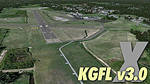
KGFL - Glens Falls, Floyd Bennett Memorial v3.0, located in the foothills of the Adirondack Mountains in upstate NY USA, this facility is owned by Warren County and run by RichAir. Although it has a 5000 ft main rwy, KGFL is a Non-controlled airfield catering to small engine a/c up to a few private jet daily traffic serving 'The Northcountry' New York. KGFL recently received several upgrades including 4 new GA hangars large enough to accommodate the needs of business jets. All Objects fully designed and completely redone in GMAX using high resolution custom photo-real textures. Complete rebuild from the ground up for FSX since v2.2 for Fs9. Also includes new ADE file, more accurate airport grounds perimeter, satellite photo-real grounds, custom taxiways, 3D taxi-signs and taxi lights, area roads, animated hangar doors, and near area landclass. No AI traffic tracks included with this release, but ADE designed to support several AI. FSX Acceleration required.
| Filename: | KGFL__Floyd_Bennett_Memorial__Glens_Falls_New_York.zip |
| License: | Freeware, limited distribution |
| Added: | 5th February 2013, 06:14:14 |
| Downloads: | 2,293 |
| Author: | EdGeneer Cox |
| Size: | 143.72 MB |
| Category: Flight Simulator X - AFCAD Files | |
| PASD - Sand Point, Alaska |
|
Images related to this file:
File Description:
The airport of Sand Point (PASD) has been extended since Microsoft has modeled it and even after the upgrade through Scenery Solution's Ultimate Terrain X Alaska has been produced. This AFCAD is built on the UTX version of the airport and is intended to be used in this environment only.
The file considers the extended runway, VASI4 at both ends with 3.6 deg glideslope and the necessary new water-polygon. Due to the specific coastline bitmaps used by UTX I had to change to Microsoft's default ones being accessible through the wonderful tool Airport Design Editor X. Some additional landclass in the airport's vicinity and three (default) buildings close to the apron are completing the changes. I did not touch the easterly landing stage (or whatever it could have been) even if Google suggests that it disappeared meanwhile except some remaining piles in the water - it's just looking nice. ;-)
| Filename: | PASD__Sand_Point_Alaska.zip |
| License: | Freeware |
| Added: | 17th October 2013, 18:55:00 |
| Downloads: | 376 |
| Author: | Axel Birsul |
| Size: | 646.25 KB |
| Category: Flight Simulator X - AFCAD Files | |
| KCJR - Culpeper Regional Airport - Virginia, USA |
|
Images related to this file:
File Description:
Culpeper Regional Airport (ICAO: KCJR, FAA LID: CJR) is a county-owned public-use airport located seven nautical miles (13 km) northeast of the central business district of Culpeper, a city in Culpeper County, Virginia, United States.Located in Brandy Station, Virginia, the airport opened in 1968. The runway originally measured 3200 ft. by 75 ft. In 1983, the runway was lengthened to 4000 ft. In 2004, the runway was expanded to 5000 ft. by 100 ft. It can handle corporate size jets and large twin engine aircraft. The airport has an airfest every October since 1998, with performances such as aerobatics.
Created with Airport Design Editor by ScruffyDuck Software using current FAA documentation and Google Earth measurements, this package offers a replacement for FSX's stock airport. All these enhancements are as close to the real airport as I can get with stock library objects.
| Filename: | KCJR__Culpeper_Regional_Airport__Virginia_USA.zip |
| License: | Freeware |
| Added: | 19th September 2014, 00:13:38 |
| Downloads: | 175 |
| Author: | Wayne Roberts |
| Size: | 6.82 KB |
| Category: Flight Simulator X - Scenery | |
| KCLL Easterwood Airport College Station Texas USA |
|
Images related to this file:
File Description:
Easterwood College Station Texas Airport for FSX. Several improvements have been made to the default airport. The default terminal building has been replaced with one created in FSDS; aircraft gates have been correctly coded using Airport Design Editor 1.70.6042; a new airport vehicle network has been built to prevent airport vehicles from entering the taxiways; extra fuel trucks have been added throughout the airport; the tower view has been changed to display from the roof of the control tower; all taxiway signs are correctly placed and all taxiway designators are correctly named; there is the option to open all runways to AI traffic; optionally, a set of GA flight plans is included using all default FSX aircraft to liven up the GA area; and Jim Dhaenen's excellent ramp lights are also included. Please refer to the README.txt file to insure proper installation of all files.
| Filename: | KCLL_Easterwood_Airport_College_Station_Texas_USA.zip |
| License: | Freeware, limited distribution |
| Added: | 25th November 2017, 16:08:22 |
| Downloads: | 442 |
| Author: | Patrick Finch |
| Size: | 1.09 MB |
| Category: Prepar3D V1-4 - Scenery | |
| KMSN - Madison Wisconsin USA Dane County Airport |
|
Images related to this file:
File Description:
Madison Wisconsin Dane County Regional Airport for P3D. Originally created for FSX, this airport has been converted to work in P3D. Several improvements have been made to the default airport. The default terminal buildings have been replaced with buildings created in FSDS; aircraft gates have been correctly coded using Airport Design Editor 1.76.6582; a new airport vehicle network has been built; extra fuel trucks have been added throughout the airport; the tower view has been changed to display from the roof of the control tower; a missing taxiway has been added, and all taxiway signs are correctly placed and named; there is the option to open all three runways to AI traffic; the 115th Fighter Wing of the Wisconsin Air National Guard is represented; and Jim Dhaenen's excellent ramp lights are also included. Please refer to the README FIRST.txt file to insure proper installation of all files.
| Filename: | KMSN__Madison_Wisconsin_USA_Dane_County_Airport.zip |
| License: | Check within download |
| Added: | 29th March 2018, 02:45:51 |
| Downloads: | 678 |
| Author: | Patrick Finch |
| Size: | 2.47 MB |
© 2001-2026 AVSIM Online
All Rights Reserved
Privacy Policy |