
Where Flight Simulation Enthusiasts Gather from Around the World!
AVSIM Library - Search Results

| Category: Flight Simulator X - Scenery | |
| FSX - EGLL London Heathrow with Terminal 5 |

|
Images related to this file:
File Description:
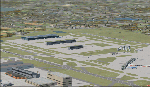
FSX scenery of Heathrow with terminal 5, parking and docking in accordance with NATS Ground movement chart (AD 2-EGLL-2-4) for terminal 5. Scenery includes more than 70 ground movement objects throughout the airport.
Although basic, this scenery closely represents Heathrow's terminal 5 and is sufficiently accurate for those that can't wait for, can't afford or don't want to purchase a commercial version.
| Filename: | FSX__EGLL_London_Heathrow_with_Terminal_5.zip |
| License: | Freeware, limited distribution |
| Added: | 13th May 2010, 21:07:18 |
| Downloads: | 11,002 |
| Author: | Tim Dale |
| Size: | 359.4 KB |
| Category: Navigation and ATC - Navigation | |
| Green Bay Sectional Chart Chunks for Aerosoft's FSMap |
|
File Description:
Sectional chart chunks made from the August 2009 Sectional charts at the original scale, formatted in the WGS84 lat/long geographic coordinate system for the FSMap, moving map application for flight simulation use. The chart chunks are the full sectional divided by 2 tiles (east/west) and converted to baseline 8bit tiffs with packbits compression applied. The images average 6,000x6,000 pixels at about 25mb each, also included is the FSMap fsm Calibration file for importing.
| Filename: | Green_Bay_Sectional_Chart_Chunks_for_Aerosofts_FSM.zip |
| License: | Freeware |
| Added: | 22nd March 2010, 20:40:23 |
| Downloads: | 326 |
| Author: | David Myers |
| Size: | 28.25 MB |
| Category: Navigation and ATC - Navigation | |
| Lake Huron Sectional Chart Chunks for Aerosoft's FSMap |
|
File Description:
Sectional chart chunks made from the August 2009 Sectional charts at the original scale, formatted in the WGS84 lat/long geographic coordinate system for the FSMap, moving map application for flight simulation use. The chart chunks are the full sectional divided by 2 tiles (east/west) and converted to baseline 8bit tiffs with packbits compression applied. The images average 6,000x6,000 pixels at about 25mb each, also included is the FSMap fsm Calibration file for importing.
| Filename: | Lake_Huron_Sectional_Chart_Chunks_for_Aerosofts_FS.zip |
| License: | Freeware |
| Added: | 22nd March 2010, 20:40:41 |
| Downloads: | 337 |
| Author: | David Myers |
| Size: | 32.26 MB |
| Category: Navigation and ATC - Navigation | |
| New York Sectional Chart Chunks for Aerosoft's FSMap |
|
File Description:
Sectional chart chunks made from the August 2009 Sectional charts at the original scale, formatted in the WGS84 lat/long geographic coordinate system for the FSMap, moving map application for flight simulation use. The chart chunks are the full sectional divided by 2 tiles (east/west) and converted to baseline 8bit tiffs with packbits compression applied. The images average 6,000x6,000 pixels at about 25mb each, also included is the FSMap fsm Calibration file for importing.
| Filename: | New_York_Sectional_Chart_Chunks_for_Aerosofts_FSMa.zip |
| License: | Freeware |
| Added: | 22nd March 2010, 20:56:39 |
| Downloads: | 528 |
| Author: | David Myers |
| Size: | 34.43 MB |
| Category: Navigation and ATC - Navigation | |
| Papua New Guinea charts 3 of 3 |
|
Images related to this file:
File Description:
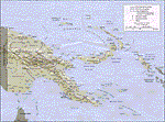
Re-upload. Calibrated for FSMap, but scanned images can be used in other map software, such as FSM Moving Map (FSMMM) by Rana Hossain. Chart source: Topographic Maps U.S. Army Map Service, Series T504, original scale 1:250,000, date 1964-. Courtesy of the University of Texas Libraries, The University of Texas at Austin. Missing: I could not find equivalent charts for New Britain; for this island, a lower-quality chart is included.
| Filename: | Papua_New_Guinea_charts_3_of_3.zip |
| License: | Freeware |
| Added: | 5th June 2010, 05:26:20 |
| Downloads: | 516 |
| Author: | David Wilson-Okamura |
| Size: | 35.88 MB |
| Category: Navigation and ATC - Navigation | |
| Montreal Sectional Chart Chunks for Aerosoft's FSMap |
|
File Description:
Sectional chart chunks made from the August 2009 Sectional charts at the original scale, formatted in the WGS84 lat/long geographic coordinate system for the FSMap, moving map application for flight simulation use. The chart chunks are the full sectional divided by 2 tiles (east/west) and converted to baseline 8bit tiffs with packbits compression applied. The images average 6,000x6,000 pixels at about 25mb each, also included is the FSMap fsm Calibration file for importing.
| Filename: | Montreal_Sectional_Chart_Chunks_for_Aerosofts_FSMa.zip |
| License: | Freeware |
| Added: | 22nd March 2010, 20:40:58 |
| Downloads: | 436 |
| Author: | David Myers |
| Size: | 35.53 MB |
| Category: Navigation and ATC - Navigation | |
| Halifax Sectional Chart Chunks for Aerosoft's FSMap |
|
File Description:
Sectional chart chunks made from the August 2009 Sectional charts at the original scale, formatted in the WGS84 lat/long geographic coordinate system for the FSMap, moving map application for flight simulation use. The chart chunks are the full sectional divided by 2 tiles (east/west) and converted to baseline 8bit tiffs with packbits compression applied. The images average 6,000x6,000 pixels at about 25mb each, also included is the FSMap fsm Calibration file for importing.
| Filename: | Halifax_Sectional_Chart_Chunks_for_Aerosofts_FSMap.zip |
| License: | Freeware |
| Added: | 22nd March 2010, 22:27:02 |
| Downloads: | 362 |
| Author: | David Myers |
| Size: | 29.08 MB |
| Category: Navigation and ATC - Navigation | |
| Chicago Sectional Chart Chunks for Aerosoft's FSMap |
|
File Description:
Sectional chart chunks made from the August 2009 Sectional charts at the original scale, formatted in the WGS84 lat/long geographic coordinate system for the FSMap, moving map application for flight simulation use. The chart chunks are the full sectional divided by 2 tiles (east/west) and converted to baseline 8bit tiffs with packbits compression applied. The images average 6,000x6,000 pixels at about 25mb each, also included is the FSMap fsm Calibration file for importing.
| Filename: | Chicago_Sectional_Chart_Chunks_for_Aerosofts_FSMap.zip |
| License: | Freeware |
| Added: | 22nd March 2010, 20:40:31 |
| Downloads: | 514 |
| Author: | David Myers |
| Size: | 31.9 MB |
| Category: Navigation and ATC - Navigation | |
| Detroit Sectional Chart Chunks for Aerosoft's FSMap |
|
File Description:
Sectional chart chunks made from the August 2009 Sectional charts at the original scale, formatted in the WGS84 lat/long geographic coordinate system for the FSMap, moving map application for flight simulation use. The chart chunks are the full sectional divided by 2 tiles (east/west) and converted to baseline 8bit tiffs with packbits compression applied. The images average 6,000x6,000 pixels at about 25mb each, also included is the FSMap fsm Calibration file for importing.
| Filename: | Detroit_Sectional_Chart_Chunks_for_Aerosofts_FSMap.zip |
| License: | Freeware |
| Added: | 22nd March 2010, 20:40:50 |
| Downloads: | 390 |
| Author: | David Myers |
| Size: | 33.56 MB |
| Category: Flight Simulator 2004 - Miscellaneous Files | |
| Captain Sim C-130E Take-off and Landing Chart |
|
File Description:
Take-off and landing chart for the Captain Sim C-130E as taken from the actual Hercules manual lent to me by a real-world C130 pilot (thx Luis!).
| Filename: | Captain_Sim_C130E_Takeoff_and_Landing_Chart.zip |
| License: | Freeware, limited distribution |
| Added: | 16th November 2005, 16:29:15 |
| Downloads: | 10,935 |
| Author: | Christian Conesa |
| Size: | 33.17 KB |
© 2001-2026 AVSIM Online
All Rights Reserved
Privacy Policy |