
Where Flight Simulation Enthusiasts Gather from Around the World!
AVSIM Library - Search Results

| Category: Flight Simulator X - Aircraft Repaints, Textures and Modifications | |
| Lucky Air Airbus A320-214 |

|
Images related to this file:
File Description:
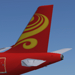
Lucky Air Airbus A320-214 for Flight Simulator X. Aircraft model and texture of B-6943 are included, along with panel, sound & virtual cockpit from the default A321. Original aircraft by Project Airbus, texture by Lingyuan He from China. The aircraft illustrated was the first A320-200 for the airlines, which joined the fleet in June 2012. Note: This package can be used in FS9, please read the instructions inside the package.
| Filename: | Lucky_Air_Airbus_A320214.zip |
| License: | Freeware, limited distribution |
| Added: | 5th October 2012, 02:37:45 |
| Downloads: | 358 |
| Author: | Lingyuan He, Project Arbus |
| Size: | 15.37 MB |
| Category: Flight Simulator 2004 - Aircraft Repaints, Textures and Modifications | |
| Amerer Air Lockheed L-188 Electra (OE-ILA) |
|
Images related to this file:
File Description:
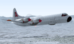
Textures for Chris Buff's Lockheed L-188 - repainted by Manfred Meyer.
You need to download the ELEC-CB.ZIP or L188electra.zip.
These textures depict OE-ILA (c/n 1145) originally delivered 1961 to Western Air Lines as N9746C. The Electra was converted to freighter in 1969 and sold to International Jet Air, Canada as CF-IJJ. In 1972 she came to Europe as LN-MOI for Nordic Air A/S, Norway and 1973 to Fred Olsen. Amerer Air from Linz in Austria bought the plane in September 1997 and used it for freight contract flights throughout Europe until 2006. Sold to Buffalo Airways,Yellowknife, Canada, in 2007 as C-GLBA.
| Filename: | Amerer_Air_Lockheed_L188_Electra_OEILA.zip |
| License: | Freeware |
| Added: | 10th March 2015, 00:03:49 |
| Downloads: | 170 |
| Author: | Manfred Meyer |
| Size: | 1.26 MB |
| Category: Fly! II - TerraScene | |
| Toledo (Ohio Project) TerraScene Project Pack |
|
File Description:
This is a TerraScene 2.1 Project pack for northwestern Ohio. It covers all of global tile 196,160 with Toledo in the center. It extends into Michigan to the north, including the southern part of Detroit. I have included a grass underlay for Detroit Grosse Ile Airport, which sits on Grosse Ile island. This pack includes updated Tiger Census (2000) shapefile data, adding new water areas, new highways, and other details. All scenery data files are included: USGS data, shapefiles, and a complete water mask. Requires TerraScene 2.1 and Fly!II patched to v240.
| Filename: | Toledo_Ohio_Project_TerraScene_Project_Pack.zip |
| License: | Freeware |
| Added: | 11th April 2003, 23:53:22 |
| Downloads: | 189 |
| Author: | Randall Rocke |
| Size: | 48.69 MB |
| Category: Fly! II - TerraScene | |
| Mansfield (Ohio Project) TerraScene Project Pack |
|
File Description:
This is a TerraScene 2.1 Project pack for the area of Mansfield, Ohio, including all of global tile 197,159. This pack includes updated Tiger Census (2000) shapefile data, adding new water areas, new highways, and other details. All scenery data files are included: USGS data, shapefiles, and a complete water mask. Requires TerraScene 2.1 and Fly!II patched to v230 or later.
| Filename: | Mansfield_Ohio_Project_TerraScene_Project_Pack.zip |
| License: | Freeware |
| Added: | 5th April 2003, 10:38:31 |
| Downloads: | 157 |
| Author: | Randall Rocke |
| Size: | 43.73 MB |
| Category: Fly! II - TerraScene | |
| Brunswick (Carolinas Project) TerraScene Project Pack |
|
File Description:
This is a TerraScene 2.1 Project pack for the area of Brunswick and the southern portion of Savannah, GA, including all of global tile 198,151. Combine this global tile with the Hilton Head tile to prevent the "capitation" of Savannah. Savannah sits directly on the tile borders, so this will give you the whole city. This tile continues the GA coastline to just south of Brunswick and Glynco Jetport. This pack includes updated Tiger Census (2000) shapefile data, adding new water areas, new highways, and other details. All scenery data files are included: USGS data, shapefiles, and a complete custom water mask. Requires TerraScene 2.1 and Fly!II patched to v230 or later.
| Filename: | Brunswick_Carolinas_Project_TerraScene_Project_Pac.zip |
| License: | Freeware |
| Added: | 4th June 2003, 12:19:47 |
| Downloads: | 194 |
| Author: | Randall Rocke |
| Size: | 24.24 MB |
| Category: Fly! II - TerraScene | |
| Wilmington (Carolinas Project) TerraScene Project Pack |
|
File Description:
This TerraScene 2.1 Project pack covers all of global tile 200,153, with the Atlantic coastline running from Topsoil Beach in the NE past Wilmington and finishing at North Myrtle Beach and Grand Strand. To the north you will find Lake Waccamaw and the Green Swamp. This pack includes updated Tiger Census (2000) shapefile data, adding new water areas, new highways, and other details. All scenery data files are included: USGS data, shapefiles, and a complete custom water mask. Requires TerraScene 2.1 and Fly!II patched to v230 or later.
| Filename: | Wilmington_Carolinas_Project_TerraScene_Project_Pa.zip |
| License: | Freeware |
| Added: | 4th June 2003, 15:45:24 |
| Downloads: | 159 |
| Author: | Randall Rocke |
| Size: | 47.54 MB |
| Category: Fly! II - TerraScene | |
| Maysville (Ohio Project) TerraScene Project Pack |
|
File Description:
This is a TerraScene 2.1 Project pack for southern Ohio and portions of northern Kentucky. It covers all of global tile 196,157 with Maysville, KY in the center. Above the Ohio River, you will find a portion of southern Ohio, with rolling hills and small towns, extending from Portsmouth, OH in the east to just below Cincinnati in the west. This pack includes updated Tiger Census (2000) shapefile data, adding new water areas, new highways, and other details. All scenery data files are included: USGS data, shapefiles, and a complete water mask. Requires TerraScene 2.1 and Fly!II patched to v230 or later.
| Filename: | Maysville_Ohio_Project_TerraScene_Project_Pack.zip |
| License: | Freeware |
| Added: | 4th May 2003, 14:51:31 |
| Downloads: | 174 |
| Author: | Randall Rocke |
| Size: | 61.6 MB |
| Category: Fly! II - TerraScene | |
| Charlotte (Carolinas Project) TerraScene Project Pack |
|
File Description:
This TerraScene 2.1 Project pack covers all of global tile 198,154, centering on Charlotte, North Carolina with Lake Wylie and the Rock Hill, SC region to the southwest. It adjoins the Spartanburg global tile to the west and the Winston-Salem tile to the north. This pack includes updated Tiger Census (2000) shapefile data, adding new water areas, new highways, and other details. All scenery data files are included: USGS data, shapefiles, and a complete water mask. Requires TerraScene 2.1 and Fly!II patched to v230 or later.
| Filename: | Charlotte_Carolinas_Project_TerraScene_Project_Pack.zip |
| License: | Freeware |
| Added: | 15th September 2003, 14:23:31 |
| Downloads: | 283 |
| Author: | Randall Rocke |
| Size: | 68.88 MB |
| Category: Fly! II - TerraScene | |
| Edenton (Carolinas Project) TerraScene Project Pack |
|
File Description:
This TerraScene 2.1 Project pack covers all of global tile 201,155, It includes the area east of Greenville, NC, Elizabeth City, Albemarle Sound and part of the outer banks. This pack includes updated Tiger Census (2000) shapefile data, adding new water areas, new highways, and other details. All scenery data files are included: USGS data, shapefiles, and a complete custom water mask. Requires TerraScene 2.1 and Fly!II patched to v230 or later.
| Filename: | Edenton_Carolinas_Project_TerraScene_Project_Pack.zip |
| License: | Freeware |
| Added: | 7th May 2010, 10:57:25 |
| Downloads: | 162 |
| Author: | Randall Rocke |
| Size: | 69.19 MB |
| Category: Fly! II - TerraScene | |
| Parkersburg (Ohio Project) TerraScene Project Pack |
|
File Description:
This is a TerraScene 2.1 Project pack for southeastern Ohio and portions of adjoining states. It covers all of global tile 198,158 with Parkersburg, WV in the west and Clarksburg (Benedum) in the east. The Ohio portion is in the NE area of the tile, above the Ohio River, including rolling hills, small towns like Marietta and a, number of small county airports. This pack includes updated Tiger Census (2000) shapefile data, adding new water areas, new highways, and other details. All scenery data files are included: USGS data, shapefiles, and a complete water mask. Requires TerraScene 2.1 and Fly!II patched to v230 or later.
| Filename: | Parkersburg_Ohio_Project_TerraScene_Project_Pack.zip |
| License: | Freeware |
| Added: | 11th May 2010, 00:52:03 |
| Downloads: | 312 |
| Author: | Randall Rocke |
| Size: | 62.89 MB |


© 2001-2026 AVSIM Online
All Rights Reserved
Privacy Policy |