
Where Flight Simulation Enthusiasts Gather from Around the World!
AVSIM Library - Search Results

| Category: Flight Simulator X - Scenery | |
| AthensBlds Downtown Athens Buildings |

|
Images related to this file:
File Description:
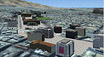
AthensBlds scenery contain buildings positioned exactly in Athens and especially the downtown area around the Athinaiko Airport to enhance the scenery and challenge the pilot and his landing skills.
The scenery is rather detailed but its worth it. Night flying is a plus.
| Filename: | AthensBlds_Downtown_Athens_Buildings.zip |
| License: | Freeware |
| Added: | 6th February 2011, 23:14:17 |
| Downloads: | 2,639 |
| Author: | Angelo Tassoglou |
| Size: | 91.26 MB |
| Category: Flight Simulator 2004 - AFCAD Files | |
| LGSR AFCAD Update |
|
File Description:
This is an update for the HSP(Hellas Scenery Team) - LGSR v1 FS2004 scenery. I have update the taxiway signs and designators. Enjoy your flights at Greece! The HSP Scenery must be installed prior to installation and is available freely at AVSIM.
| Filename: | LGSR_AFCAD_Update.zip |
| License: | Freeware, limited distribution |
| Added: | 1st April 2012, 10:39:47 |
| Downloads: | 1,035 |
| Author: | Christopher Barbas |
| Size: | 8.65 KB |
| Category: Flight Simulator 2004 - AI Flight Plans | |
| SC RFDS Western Australia Sector - Summer 2014 |
|
File Description:
These plans get Joe Bowers repaints flying. All airports exist in FSX, either as default or 3rd party add ons. A search on blencowe will find most of them. Some are missing in FS9 as far as I know, see relevant data in the file. Data used is based on flightaware searches.
| Filename: | SC_RFDS_Western_Australia_Sector__Summer_2014.zip |
| License: | Freeware, limited distribution |
| Added: | 5th November 2014, 00:50:47 |
| Downloads: | 175 |
| Author: | Stephen Croft |
| Size: | 12.46 KB |
| Category: Flight Simulator 2004 - AI Aircraft | |
| NAM Air ATR 72-600 |
|
File Description:
FS2004/FSX NAM Air ATR 72-600. NAM Air is a regional airline part of the Sriwijaya Air group. The airline operates B737-500s but recently they've acquired ATRs in hopes to reach the smaller airports located in the remote places in Indonesia. Texture only. Base pack required (OSP72500.ZIP). By William Adityo.
| Filename: | NAM_Air_ATR_72600.zip |
| License: | Freeware |
| Added: | 14th November 2018, 15:23:56 |
| Downloads: | 300 |
| Author: | William Adityo |
| Size: | 462.89 KB |
| Category: Flight Simulator X - Utilities | |
| LACTO - Landing Performance Calculation Tool |
|
File Description:
LACTO is a tool for calculating landing length and autobrake required for the PMDG 737-800 and -900. All airports are covered. It is contained in an excel sheet. All you have to do is input the airport name and it will calculate the lowest autobrake level required for a safe landing.
| Filename: | LACTO__Landing_Performance_Calculation_Tool.zip |
| License: | Freeware, limited distribution |
| Added: | 28th October 2015, 15:04:18 |
| Downloads: | 445 |
| Author: | Oliver Mitchell |
| Size: | 47.58 KB |
| Category: Flight Simulator 2002 - AFCAD Files | |
| British Columbia, Canada: CZBB, CYXS, CYLW |
|
File Description:
AFCAD files for Boundary Bay (CZBB), Kelowna (CYLW) and Prince George (CYXS), all in British Columbia, Canada. Adds semi-accurate parking and improves traffic flow at all three airports. Great for GA traffic, especially Boundary Bay, which is a very busy flight training airport. Use CapHolland's GATM to add the Cessna swarm!
| Filename: | British_Columbia_Canada_CZBB_CYXS_CYLW.zip |
| License: | Freeware, limited distribution |
| Added: | 14th March 2003, 16:51:57 |
| Downloads: | 689 |
| Author: | Brian Burger |
| Size: | 7.74 KB |
| Category: Fly! II - Navigation | |
| Plotting Map I |
|
File Description:
The files included in the zip package can be used
to display the area covered by coast and rivers data
(used with ROTW moving map instruments), or to display
a flight user trace between airports and navaids.
Only for PC : OpenGlide rendering.
Tested with XP and NVIDIA GeForce MX 420 64 Mb
| Filename: | Plotting_Map_I.zip |
| License: | Freeware |
| Added: | 12th March 2004, 13:19:47 |
| Downloads: | 98 |
| Author: | laurent claudet (rotw) |
| Size: | 229.72 KB |
| Category: Flight Simulator 2004 - Miscellaneous Files | |
| Wilco 767 PIC Terminal Procedures for ICAOs beginning With Other Than A "K" or a "P" |
|
File Description:
This is a beta run of SIDs, STARs and IAPs for the Wilco 767 PIC version 1. There are two files for the complete set. This file is for airport ICAOs that start with something other than a 'K' or a 'P'. These are generally airports that are not in the U.S..
| Filename: | Wilco_767_PIC_Terminal_Procedures_for_ICAOs_beginn.zip |
| License: | Freeware |
| Added: | 16th November 2004, 01:17:17 |
| Downloads: | 254 |
| Author: | Terry Yingling |
| Size: | 3.45 MB |
| Category: Flight Simulator 2004 - AFCAD Files | |
| Kootenay |
|
File Description:
These are AFCAD files for three Kootenay airports, Invermere, Creston and Cranbrook. It also includes ai traffic, but to get all the traffic you must have the PAD dash 8-100, as well as the cdai beech1900d with Central Mountain Air liveries. I also recommend getting the AFCAD files found at www.projectai.com
| Filename: | Kootenay.zip |
| License: | Freeware |
| Added: | 7th September 2004, 14:10:49 |
| Downloads: | 394 |
| Author: | Adam O'Brien |
| Size: | 7.12 KB |
| Category: Fly! II - Navigation | |
| UK-Eire Map |
|
File Description:
This file will add a map of the United Kingdom & Ireland into the flight planner window.
The map is sufficiently large for you to be able to trace a suitable flight plan within the UK and Ireland, and see the
different airports at a more acceptable distance (compared to the original europe map)
| Filename: | UKEire_Map.zip |
| License: | Freeware |
| Added: | 26th December 2004, 23:20:51 |
| Downloads: | 228 |
| Author: | Daniel Arias |
| Size: | 14.74 MB |
© 2001-2026 AVSIM Online
All Rights Reserved
Privacy Policy |