
Where Flight Simulation Enthusiasts Gather from Around the World!
AVSIM Library - Search Results

| Category: Navigation and ATC - Navigation | |
| Great Falls Sectional Chart Chunks for Aerosoft's FSMap |

|
File Description:
Sectional chart chunks made from the August 2009 Sectional charts at the original scale, formatted in the WGS84 lat/long geographic coordinate system for the FSMap, moving map application for flight simulation use. The chart chunks are the full sectional divided by 2 tiles (east/west) and converted to baseline 8bit tiffs with packbits compression applied. The images average 6,000x6,000 pixels at about 25mb each, also included is the FSMap fsm Calibration file for importing. No further calibration is needed, just import, save, and enjoy.
| Filename: | Great_Falls_Sectional_Chart_Chunks_for_Aerosofts_F.zip |
| License: | Freeware |
| Added: | 24th March 2010, 19:42:09 |
| Downloads: | 382 |
| Author: | David Myers |
| Size: | 37.2 MB |
| Category: Navigation and ATC - Navigation | |
| Cape Lisburne Sectional Chart Chunks |
|
File Description:
Sectional chart chunks made from the August 2009 Sectional charts at the original scale, formatted in the WGS84 lat/long geographic coordinate system for the FSMap, moving map application for flight simulation use. The chart chunks are the full sectional divided by 2 tiles (east/west) and converted to baseline 8bit tiffs with packbits compression applied. The images average 6,000x6,000 pixels at about 25mb each, also included is the FSMap fsm Calibration file for importing. No further calibration is needed, just import, save, and enjoy.
| Filename: | Cape_Lisburne_Sectional_Chart_Chunks.zip |
| License: | Freeware |
| Added: | 26th March 2010, 00:23:32 |
| Downloads: | 344 |
| Author: | David Myers |
| Size: | 14.9 MB |
| Category: Navigation and ATC - Navigation | |
| Anchorage Sectional & TAC Chart Chunks |
|
File Description:
Sectional chart chunks made from the August 2009 Sectional charts at the original scale, formatted in the WGS84 lat/long geographic coordinate system for the FSMap, moving map application for flight simulation use. The chart chunks are the full sectional divided by 2 tiles (east/west) and converted to baseline 8bit tiffs with packbits compression applied. The images average 6,000x6,000 pixels at about 25mb each, also included is the FSMap fsm Calibration file for importing. No further calibration is needed, just import, save, and enjoy.
| Filename: | Anchorage_Sectional__TAC_Chart_Chunks.zip |
| License: | Freeware |
| Added: | 26th March 2010, 00:23:18 |
| Downloads: | 623 |
| Author: | David Myers |
| Size: | 37.97 MB |
| Category: Navigation and ATC - Navigation | |
| Bethel Sectional Chart Chunks |
|
File Description:
Sectional chart chunks made from the August 2009 Sectional charts at the original scale, formatted in the WGS84 lat/long geographic coordinate system for the FSMap, moving map application for flight simulation use. The chart chunks are the full sectional divided by 2 tiles (east/west) and converted to baseline 8bit tiffs with packbits compression applied. The images average 6,000x6,000 pixels at about 25mb each, also included is the FSMap fsm Calibration file for importing. No further calibration is needed, just import, save, and enjoy.
| Filename: | Bethel_Sectional_Chart_Chunks.zip |
| License: | Freeware |
| Added: | 26th March 2010, 00:23:26 |
| Downloads: | 414 |
| Author: | David Myers |
| Size: | 19.43 MB |
| Category: Navigation and ATC - Navigation | |
| Brownsville Sectional Chart Chunks |
|
File Description:
Sectional chart chunks made from the August 2009 Sectional charts at the original scale, formatted in the WGS84 lat/long geographic coordinate system for the FSMap, moving map application for flight simulation use. The chart chunks are the full sectional divided by 2 tiles (east/west) and converted to baseline 8bit tiffs with packbits compression applied. The images average 6,000x6,000 pixels at about 25mb each, also included is the FSMap fsm Calibration file for importing. No further calibration is needed, just import, save, and enjoy.
| Filename: | Brownsville_Sectional_Chart_Chunks.zip |
| License: | Freeware |
| Added: | 28th March 2010, 00:22:19 |
| Downloads: | 351 |
| Author: | David Myers |
| Size: | 23.81 MB |
| Category: Navigation and ATC - Navigation | |
| McGrath Sectional Chart Chunks |
|
File Description:
Sectional chart chunks made from the August 2009 Sectional charts at the original scale, formatted in the WGS84 lat/long geographic coordinate system for the FSMap, moving map application for flight simulation use. The chart chunks are the full sectional divided by 2 tiles (east/west) and converted to baseline 8bit tiffs with packbits compression applied. The images average 6,000x6,000 pixels at about 25mb each, also included is the FSMap fsm Calibration file for importing. No further calibration is needed, just import, save, and enjoy.
| Filename: | McGrath_Sectional_Chart_Chunks.zip |
| License: | Freeware |
| Added: | 30th March 2010, 00:32:25 |
| Downloads: | 309 |
| Author: | David Myers |
| Size: | 23.44 MB |
| Category: Navigation and ATC - Navigation | |
| Nome Sectional Chart Chunks |
|
File Description:
Sectional chart chunks made from the August 2009 Sectional charts at the original scale, formatted in the WGS84 lat/long geographic coordinate system for the FSMap, moving map application for flight simulation use. The chart chunks are the full sectional divided by 2 tiles (east/west) and converted to baseline 8bit tiffs with packbits compression applied. The images average 6,000x6,000 pixels at about 25mb each, also included is the FSMap fsm Calibration file for importing. No further calibration is needed, just import, save, and enjoy.
| Filename: | Nome_Sectional_Chart_Chunks.zip |
| License: | Freeware |
| Added: | 30th March 2010, 00:32:58 |
| Downloads: | 342 |
| Author: | David Myers |
| Size: | 20.21 MB |
| Category: Prepar3D V1-4 - Aircraft Repaints, Textures and Modifications | |
| De Havilland DH-82 Tiger Moth (G-ACDC) |
|
Images related to this file:
File Description:

This folder contains a repaint for Ant's DH-82 Tiger Moth Pro for P3DV4+. It shows Tiger Moth G-ACDC, which was built in 1933 with c/n 3177 as one of the first 10 Tiger Moths, making it the oldest flying Tiger Moth in the word. During the war it became BB726 with the RAF, returning to G-ACDC after the war. It is still current in the UK, with over 13000 flying hours. Repaint by Jan Kees Blom, based on the paintkit by Anthony Lynch
| Filename: | De_Havilland_DH82_Tiger_Moth_GACDC.zip |
| License: | Freeware |
| Added: | 8th December 2019, 18:00:16 |
| Downloads: | 143 |
| Author: | Jan Kees Blom |
| Size: | 7.09 MB |
| Category: Flight Simulator X - Aircraft Repaints, Textures and Modifications | |
| Hellenic Air Force, Douglas DC-3 / C-47 - package |
|
Images related to this file:
File Description:
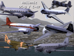
These is a repaint (textures only) package for the default FSX DOUGLAS DC-3. These textures represent seven DC-3/C-47 that flew in Greek skies : the SX-BAL C-47 of TAE National Greek Airlines, the SX-BAG DC-3 of Olympic Airways, the 92622 of Royal Hellenic Air Force C-47, the SX-ECF Douglas DC-3 of Hellenic Civil Aviation Authority, the KJ960 of Hellenic Air Force (HAF) DC-3, the KP255 DC-3 of HAF and the 492822 HAF DC-3.
| Filename: | Hellenic_Air_Force_Douglas_DC3__C47__package.zip |
| License: | Freeware |
| Added: | 4th February 2012, 19:33:48 |
| Downloads: | 401 |
| Author: | Astrios Tso |
| Size: | 10.82 MB |
| Category: Navigation and ATC - Navigation | |
| Dawson Sectional Chart Chunks for Aerosoft's FSMap |
|
File Description:
Sectional chart chunks made from the August 2009 Sectional charts at the original scale, formatted in the WGS84 lat/long geographic coordinate system for the FSMap, moving map application for flight simulation use. The chart chunks are the full sectional divided by 2 tiles (east/west) and converted to baseline 8bit tiffs with packbits compression applied. The images average 6,000x6,000 pixels at about 25mb each, also included is the FSMap fsm Calibration file for importing. No further calibration is needed, just import, save, and enjoy.
| Filename: | Dawson_Sectional_Chart_Chunks_for_Aerosofts_FSMap.zip |
| License: | Freeware |
| Added: | 26th March 2010, 00:23:50 |
| Downloads: | 345 |
| Author: | David Myers |
| Size: | 19.88 MB |


© 2001-2026 AVSIM Online
All Rights Reserved
Privacy Policy |