
Where Flight Simulation Enthusiasts Gather from Around the World!
AVSIM Library - Search Results

| Category: Flight Simulator 2004 - AI Aircraft | |
| United 2010 Boeing 747-400 |

|
Images related to this file:
File Description:

United Airlines Boeing 747-400. Repaint of Boeing 747-400 in United Airlines 2010 colors for use with the AI Aardvark B747-400. Base files available separately (AI74DUPG.ZIP). Visit us at www.alpha-india.net for more information.
| Filename: | United_2010_Boeing_747400.zip |
| License: | Freeware |
| Added: | 9th March 2011, 19:30:13 |
| Downloads: | 4,216 |
| Author: | Juergen Baumbusch and Alpha India Group |
| Size: | 1022.37 KB |
| Category: Flight Simulator 2004 - Aircraft Repaints, Textures and Modifications | |
| World Airways McDonnell Douglas MD-11 New Colours |
|
File Description:
Repaint World Airways MD-11 FSPainter new Colours Reg. N272WA
See also AI-Traffic-Files "wo06v10.zip" and "wo06v11.zip"
| Filename: | World_Airways_McDonnell_Douglas_MD11_New_Colours.zip |
| License: | Freeware |
| Added: | 19th August 2007, 11:35:50 |
| Downloads: | 1,314 |
| Author: | Hans-Jürgen Mind and Lutz Fischer |
| Size: | 350.75 KB |
| Category: Flight Simulator 2004 - AI Aircraft | |
| Ryanair Boeing 737-800 Comunitat Valenciana logojets |
|
Images related to this file:
File Description:

Ryanair currently operates several of its Boeing 737-800s with added 'Comunitat Valenciana' logos and titles. This package includes three variations. Please read the included fleet detail document for more details. These are textures only, in both 32bits and dxt3 (mipped and non-mipped) formats. You need the AI Aardvark Boeing 737-800 (winglet model) base package available separately. Repaint by Philippe Tabatchnik for Alpha India Group. Visit us at www.alpha-india.net for more information. Our special thanks go to our beta testers whose sharp eyes can spot our mistakes before we can pass them on to you!
| Filename: | Ryanair_Boeing_737800_Comunitat_Valenciana_logojet.zip |
| License: | Freeware, limited distribution |
| Added: | 9th October 2011, 21:16:13 |
| Downloads: | 1,430 |
| Author: | Philippe Tabatchnik and Alpha India Group |
| Size: | 3.89 MB |
| Category: Flight Simulator 2004 - AI Aircraft | |
| United Express Embraer ERJ-145 |
|
Images related to this file:
File Description:

FS2004 United Express Embraer ERJ-145. Repaint of Embraer ERJ-145 in United Express 2010 color, for use with the AIM ERJ-145. Base files available separately AIM_ERJ145.ZIP. Visit us at www.alpha-india.net for more information.
| Filename: | United_Express_Embraer_ERJ145.zip |
| License: | Freeware |
| Added: | 10th March 2011, 00:02:01 |
| Downloads: | 9,870 |
| Author: | Juergen Baumbusch and Alpha India Group |
| Size: | 897.59 KB |
| Category: Flight Simulator 2004 - AI Aircraft | |
| Estonian Air Boeing 737-500 |
|
Images related to this file:
File Description:

Repaint of Boeing 737-500 in Estonian Air color for use with the AI Aardvark B737-500. Base files available separately (AIA735V2.ZIP) Visit us at www.alpha-india.net for more information.
| Filename: | Estonian_Air_Boeing_737500.zip |
| License: | Freeware |
| Added: | 9th March 2011, 18:12:02 |
| Downloads: | 924 |
| Author: | Juergen Baumbusch and Alpha India Group |
| Size: | 1.1 MB |
| Category: Flight Simulator X - Scenery | |
| CYUY Rouyn-Noranda |
|
Images related to this file:
File Description:
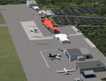
CYUY Rouyn-Noranda airport, in western Quebec: tower, terminal, hangars, static aircraft and vehicles. Mining installations (mine, CTP9 Donaldson-Kattinik airport and sea harbour). FSX default buildings, vehicles, airport objects and reindeers!
| Filename: | CYUY_RouynNoranda.zip |
| License: | Freeware |
| Added: | 15th May 2013, 00:00:14 |
| Downloads: | 1,234 |
| Author: | Jean-Pierre Fillion and Pierre Gallant |
| Size: | 12.73 MB |
| Category: Flight Simulator 2004 - Scenery | |
| "Himalayan Peaks" LOD10 Mesh, Volume 3 - Namcha Barwa |
|
File Description:
Highly detailed terrain mesh of the Namcha Barwa area, N29°-31° E94°-96°. The files in this package are based on Shuttle Radar (SRTM) Version 2 data but with many of the void areas, especially the most significant sections, filled with elevation data generated from topographic maps by Jonathan de Ferranti. While Jonathan's work is unrelated to flight simulation he kindly gave me permission to compile his data for use in FS. The result is a wonderful improvement in detail and accuracy over any existing mesh file, freeware or commercial, based on SRTM or DTED data alone. Due to the large area of the Himalayas I've compiled the source data as two separate series: the "Himalayan Peaks" series covers prominent mountains and ranges in higher detail and locally overrides any existing LOD9 terrain mesh. In addition, a LOD9 "base mesh" series covering the entire Himalayas will be available for those who do not yet have an add-on terrain mesh of these beautiful mountains.
| Filename: | Himalayan_Peaks_LOD10_Mesh_Volume_3__Namcha_Barwa.zip |
| License: | Freeware, limited distribution |
| Added: | 18th February 2006, 23:15:17 |
| Downloads: | 12,188 |
| Author: | Holger Sandmann and Jonathan de Ferranti |
| Size: | 15.09 MB |
| Category: Flight Simulator 2004 - Scenery | |
| "Himalayan Peaks" LOD10 Mesh, Volume 5 - Garhwal |
|
File Description:
Highly detailed terrain mesh of the Garhwal area, N30°-32° E78°-81°. The files in this package are based on Shuttle Radar (SRTM) Version 2 data but with many of the void areas, especially the most significant sections, filled with elevation data generated from topographic maps by Jonathan de Ferranti. While Jonathan's work is unrelated to flight simulation he kindly gave me permission to compile his data for use in FS. The result is a wonderful improvement in detail and accuracy over any existing mesh file, freeware or commercial, based on SRTM or DTED data alone. Due to the large area of the Himalayas I've compiled the source data as two separate series: the "Himalayan Peaks" series covers prominent mountains and ranges in higher detail and locally overrides any existing LOD9 terrain mesh. In addition, a LOD9 "base mesh" series covering the entire Himalayas will be available for those who do not yet have an add-on terrain mesh of these beautiful mountains.
| Filename: | Himalayan_Peaks_LOD10_Mesh_Volume_5__Garhwal.zip |
| License: | Freeware, limited distribution |
| Added: | 18th February 2006, 23:16:47 |
| Downloads: | 10,134 |
| Author: | Holger Sandmann and Jonathan de Ferranti |
| Size: | 27.72 MB |
| Category: Flight Simulator 2004 - Scenery | |
| Himalayan Peaks LOD10 Mesh, Volume 1 - Mt. Everest and Kula Kangri |
|
File Description:
Highly detailed terrain mesh of the Mt. Everest and Kula Kangri areas, N26°-29° E85°-92°. The files in this package are based on Shuttle Radar (SRTM) Version 2 data but with many of the void areas, especially the most significant sections, filled with elevation data generated from topographic maps by Jonathan de Ferranti. While Jonathan's work is unrelated to flight simulation he kindly gave me permission to compile his data for use in FS. The result is a wonderful improvement in detail and accuracy over any existing mesh file, freeware or commercial, based on SRTM or DTED data alone. Due to the large area of the Himalayas I've compiled the source data as two separate series: the "Himalayan Peaks" series covers prominent mountains and ranges in higher detail and locally overrides any existing LOD9 terrain mesh. In addition, a LOD9 "base mesh" series covering the entire Himalayas will be available for those who do not yet have an add-on terrain mesh of these beautiful mountains.
| Filename: | Himalayan_Peaks_LOD10_Mesh_Volume_1__Mt_Everest_an.zip |
| License: | Freeware, limited distribution |
| Added: | 9th February 2006, 22:13:00 |
| Downloads: | 37,047 |
| Author: | Holger Sandmann and Jonathan de Ferranti |
| Size: | 52.01 MB |
| Category: Flight Simulator X - Scenery | |
| Mesh South America / MeSA Galapagos |
|
File Description:
This terrain mesh file is a part of a whole project covering all the Continent of South America and some islands, divided in tiles identified in a map by its column (letters) and rows (numbers). Those files were multi-LOD compiled from 90m SRTM2 source data, reprocessed with 3DEM to remove voids and spikes, providing a 76.4m (LOD9) horizontal resolution topography intended for use only in FSX updated with SP1.
Although not well documented, to improve performance, the updated FSX loads DEM files in threads and only the closer terrain (about 5 NM from the point of view) is rendered in high detail, while at far distances FSX shows up its default low resolution mesh, when there is not a third part terrain mesh compiled in all others intermediate level of details (multi-LOD).
| Filename: | Mesh_South_America__MeSA_Galapagos.zip |
| License: | Freeware |
| Added: | 10th June 2007, 21:03:25 |
| Downloads: | 1,349 |
| Author: | Hely Heck Jr. and José Lôbo |
| Size: | 1.81 MB |


© 2001-2026 AVSIM Online
All Rights Reserved
Privacy Policy |