
Where Flight Simulation Enthusiasts Gather from Around the World!
AVSIM Library - Search Results

| Category: Flight Simulator X - Scenery | |
| RAF Stenigot |

|
File Description:
RAF Stenigot was a Second World War radar station situated at Stenigot, near Donington on Bain, Lincolnshire.
It was part of the Chain Home radar network, intended to provide long range early warning for raids from Luftflotte V and the northern elements of Luftflotte II along the approaches to Sheffield and Nottingham and the central midlands.
I would like to give credit and to acknowledge the following authors without whose work I could not have made this scenery; all credit for the models contained in it is theirs I merely placed it. Ted Andrews - Ian Pearson - Mike Hudson.
| Filename: | RAF_Stenigot.zip |
| License: | Freeware |
| Added: | 3rd October 2015, 18:50:05 |
| Downloads: | 309 |
| Author: | Terry Boissel |
| Size: | 130.31 KB |
| Category: X-Plane - Scenery | |
| TNCS Saba Dutch Caribbean v1.0.0 |
|
Images related to this file:
File Description:
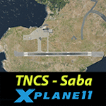
This is an X-Plane 11 scenery for Juancho E. Yrausquin Airport (ICAO: TNCS, IATA: SAB), an airport on the Dutch Caribbean island of Saba. It adds a few 3D buildings and objects. This airport is famous for housing one of the shortest commercial runways in the world, only 400 metres (1312 ft) long, flanked on one side by high hills, with cliffs that drop into the sea at both ends. This scenery was It was tested and is operational (as of January 01, 2017) in "X-Plane 11 Public Beta #3 64 bit", Windows 10 Home.
| Filename: | TNCS_Saba_Dutch_Caribbean_v100.zip |
| License: | Freeware |
| Added: | 1st January 2017, 20:18:29 |
| Downloads: | 138 |
| Author: | Rui Mesquita |
| Size: | 1.71 MB |
| Category: Flight Simulator X - Aircraft Repaints, Textures and Modifications | |
| Air Berlin USA Boeing 707-300B |
|
Images related to this file:
File Description:
Air Berlin USA Boeing 707-331B, N8729, MSN 20058 (Captain Sim)
After the second World War, only carriers from the US, UK and France were allowed to operate
flights into the West-Berlin airports. Therefore, Air Berlin USA was founded in Oregon in 1978
as a charter airline, but was based at Berlin Tegel Airport. Having leased two ex-TWA 707s,
Air Berlin started operations in spring 1979 with a flight between Palma de Mallorca and Berlin
Tegel Airport. Long-haul flights were later added on the route Berlin-Brussels-Florida, in
collaboration with Air Florida.
| Filename: | Air_Berlin_USA_Boeing_707300B.zip |
| License: | Freeware |
| Added: | 3rd October 2017, 16:12:33 |
| Downloads: | 178 |
| Author: | Sander Hartjes |
| Size: | 7.02 MB |
| Category: Flight Simulator X - Aircraft Repaints, Textures and Modifications | |
| USAF Douglas C-124C MATS Pacific Division |
|
Images related to this file:
File Description:
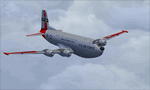
This is a repaint of the Douglas C-124C in USAF colors. The freeware Douglas C-124C for FSX by Jens Kristensen (JBK) is needed for this repaint. C-124A serial: 51-5180 was delivered to the Air Force in 1951. It began its life as a MATS aircraft and was stationed with the MATS Pacific Division, before moving on to other squadrons. After a long service life, it was retired and sent to MASDC in Arizona as CQ257 on Mar 13, 1972. Textures are 32bit DDS. This repaint was tested on FSX-SE. It should also work on FSX, and P3Dv1-3.
| Filename: | USAF_Douglas_C124C_MATS_Pacific_Division.zip |
| License: | Freeware |
| Added: | 12th November 2019, 17:39:45 |
| Downloads: | 65 |
| Author: | Ted Giana |
| Size: | 5.18 MB |
| Category: Flight Simulator 2004 - Scenery Design | |
| Caribbean Island of Dominica |
|
File Description:
This package DOES NOT contain finished FS scenery products! Instead, the two bitmaps (N15.1-15.7 W61.2-61.6) are meant to be used for FS landscape scenery design with Ground2K4 (by Christian Fumey) or similar utilities. Source data are public domain Landsat 7 ETM+ satellite images, at 15-m and 30-m ground resolution. I used professional GIS software for the geographic transformation to lat/long-WGS84 projection, and photo processing software for channel merging and image enhancements. Each image has been tested in Ground2K4 for accurate placement. Note: these images have been ECW-compressed and need special (free) software for decompressing (instructions included).
| Filename: | Caribbean_Island_of_Dominica.zip |
| License: | Freeware, limited distribution |
| Added: | 12th March 2004, 01:07:01 |
| Downloads: | 521 |
| Author: | Holger Sandmann |
| Size: | 1.42 MB |
| Category: Flight Simulator 2004 - Scenery Design | |
| Caribbean Islands of Guadeloupe |
|
File Description:
This package DOES NOT contain finished FS scenery products! Instead, the two bitmaps (N15.7-16.6 W60.9-62.0) are meant to be used for FS landscape scenery design with Ground2K4 (by Christian Fumey) or similar utilities. Source data are public domain Landsat 7 ETM+ satellite images, at 15-m and 30-m ground resolution. I used professional GIS software for the geographic transformation to lat/long-WGS84 projection, and photo processing software for channel merging and image enhancements. Each image has been tested in Ground2K4 for accurate placement. Note: these images have been ECW-compressed and need special (free) software for decompressing (instructions included).
| Filename: | Caribbean_Islands_of_Guadeloupe.zip |
| License: | Freeware, limited distribution |
| Added: | 12th March 2004, 01:15:19 |
| Downloads: | 629 |
| Author: | Holger Sandmann |
| Size: | 3.56 MB |
| Category: Flight Simulator 2004 - Scenery Design | |
| Luxor area, Nile Valley, Egypt, Bitmaps For Ground2K4 |
|
File Description:
This package DOES NOT contain finished FS scenery products! Instead, the three bitmaps (N25.2-26.5 E31.8-33.0) are meant to be used for FS landscape scenery design with Ground2K4 (by Christian Fumey) or similar utilities. Source data are public domain Landsat 7 ETM+ satellite images, at 15-m and 30-m ground resolution. I used professional GIS software for the geographic transformation to lat/long-WGS84 projection, and photo processing software for channel merging and image enhancements. Each image has been tested in Ground2K4 for accurate placement. Note: These images have been ECW-compressed and need special (free) software for decompressing (instructions included).
| Filename: | Luxor_area_Nile_Valley_Egypt_Bitmaps_For_Ground2K4.zip |
| License: | Freeware, limited distribution |
| Added: | 1st April 2004, 20:37:33 |
| Downloads: | 829 |
| Author: | Holger Sandmann |
| Size: | 19.8 MB |
| Category: Flight Simulator 2004 - Scenery Design | |
| Central Willamette Valley, Oregon |
|
File Description:
This package DOES NOT contain finished FS scenery products! Instead, the three bitmaps (N44.0-45.1 W122.4-123.5) are meant to be used for FS landscape scenery design with Ground2K4 (by Christian Fumey) or similar utilities. Source data are public domain Landsat 7 ETM+ satellite images, at 15-m and 30-m ground resolution. I used professional GIS software for the geographic transformation to lat/long-WGS84 projection, and photo processing software for channel merging and image enhancements. Each image has been tested in Ground2K4 for accurate placement. Note: These images have been ECW-compressed and need special (free) software for decompressing (instructions included).
| Filename: | Central_Willamette_Valley_Oregon.zip |
| License: | Freeware, limited distribution |
| Added: | 13th April 2004, 12:44:18 |
| Downloads: | 363 |
| Author: | Holger Sandmann |
| Size: | 19.44 MB |
| Category: Flight Simulator 2004 - Scenery Design | |
| Jasper National Park, Alberta, Canada |
|
File Description:
This package DOES NOT contain finished FS scenery products! Instead, the two bitmaps (N53.5-51.8 W119.1-116.5) are meant to be used for FS landscape scenery design with Ground2K4 (by Christian Fumey) or similar utilities. Source data are public domain Landsat 7 ETM+ satellite images, at 30-m ground resolution. I used professional GIS software for the geographic transformation to lat/long-WGS84 projection, and photo processing software for channel merging and image enhancements. Each image has been tested in Ground2K4 for accurate placement. Note: These images have been ECW-compressed and need special (free) software for decompressing (instructions included).
| Filename: | Jasper_National_Park_Alberta_Canada.zip |
| License: | Freeware, limited distribution |
| Added: | 13th April 2004, 12:44:49 |
| Downloads: | 532 |
| Author: | Holger Sandmann |
| Size: | 9.15 MB |
| Category: Flight Simulator 2004 - Scenery Design | |
| Volos and District of Magnesia, Greece |
|
File Description:
This package DOES NOT contain finished FS scenery products! Instead, the three bitmaps (N38.6-39.9 E22.4-23.3) are meant to be used for FS landscape scenery design with Ground2K4 (by Christian Fumey) or similar utilities. Source data are public domain Landsat 7 ETM+ satellite images, at 15-m and 30-m ground resolution. I used professional GIS software for the geographic transformation to lat/long-WGS84 projection, and photo processing software for channel merging and image enhancements. Each image has been tested in Ground2K4 for accurate placement. Note: These images have been ECW-compressed and need special (free) software for decompressing (instructions included).
| Filename: | Volos_and_District_of_Magnesia_Greece.zip |
| License: | Freeware, limited distribution |
| Added: | 13th April 2004, 12:46:23 |
| Downloads: | 520 |
| Author: | Holger Sandmann |
| Size: | 13.84 MB |


© 2001-2026 AVSIM Online
All Rights Reserved
Privacy Policy |