
Where Flight Simulation Enthusiasts Gather from Around the World!
AVSIM Library - Search Results

| Category: Navigation and ATC - Navigation | |
| Montreal Sectional Chart Chunks for Aerosoft's FSMap |

|
File Description:
Sectional chart chunks made from the August 2009 Sectional charts at the original scale, formatted in the WGS84 lat/long geographic coordinate system for the FSMap, moving map application for flight simulation use. The chart chunks are the full sectional divided by 2 tiles (east/west) and converted to baseline 8bit tiffs with packbits compression applied. The images average 6,000x6,000 pixels at about 25mb each, also included is the FSMap fsm Calibration file for importing.
| Filename: | Montreal_Sectional_Chart_Chunks_for_Aerosofts_FSMa.zip |
| License: | Freeware |
| Added: | 22nd March 2010, 20:40:58 |
| Downloads: | 436 |
| Author: | David Myers |
| Size: | 35.53 MB |
| Category: Navigation and ATC - Navigation | |
| New York Sectional Chart Chunks for Aerosoft's FSMap |
|
File Description:
Sectional chart chunks made from the August 2009 Sectional charts at the original scale, formatted in the WGS84 lat/long geographic coordinate system for the FSMap, moving map application for flight simulation use. The chart chunks are the full sectional divided by 2 tiles (east/west) and converted to baseline 8bit tiffs with packbits compression applied. The images average 6,000x6,000 pixels at about 25mb each, also included is the FSMap fsm Calibration file for importing.
| Filename: | New_York_Sectional_Chart_Chunks_for_Aerosofts_FSMa.zip |
| License: | Freeware |
| Added: | 22nd March 2010, 20:56:39 |
| Downloads: | 528 |
| Author: | David Myers |
| Size: | 34.43 MB |
| Category: Navigation and ATC - Navigation | |
| Halifax Sectional Chart Chunks for Aerosoft's FSMap |
|
File Description:
Sectional chart chunks made from the August 2009 Sectional charts at the original scale, formatted in the WGS84 lat/long geographic coordinate system for the FSMap, moving map application for flight simulation use. The chart chunks are the full sectional divided by 2 tiles (east/west) and converted to baseline 8bit tiffs with packbits compression applied. The images average 6,000x6,000 pixels at about 25mb each, also included is the FSMap fsm Calibration file for importing.
| Filename: | Halifax_Sectional_Chart_Chunks_for_Aerosofts_FSMap.zip |
| License: | Freeware |
| Added: | 22nd March 2010, 22:27:02 |
| Downloads: | 362 |
| Author: | David Myers |
| Size: | 29.08 MB |
| Category: Flight Simulator 2004 - Aircraft Repaints, Textures and Modifications | |
| Air New Zealand Boeing 7E7-800 Dreamliner |
|
File Description:
FS9/FS2004 Boeing B7e7-800 Air New Zealand. Air New Zealand are the second launch customer for the 7e7, looking to replace the aging 767 fleet. The 7e7-800 is the long range version of the 7e7, which can carry about 220 passengers over a distance of 8500nm, with a cruise speeds up to mach .85. The 7e7 is to have it's first flight in 2007. First delivery in 2008 to ANA.
| Filename: | Air_New_Zealand_Boeing_7E7800_Dreamliner.zip |
| License: | Freeware |
| Added: | 7th June 2004, 16:02:20 |
| Downloads: | 1,912 |
| Author: | Jon Murchison, Robert Versluys |
| Size: | 941.43 KB |
| Category: Flight Simulator 2004 - Aircraft Repaints, Textures and Modifications | |
| Bulgaria Air - Boeing 7E7-800 |
|
File Description:
FS2004 Boeing 7E7-800 in Bulgari@air livery. The B7E7-800 ' Dreamliner ' is intended to replace the 757 and 767 and to compete with the Airbus A330. The 7E7-800 is the long range version of the 7E7, which can carry about 220 passengers over a distance of 8500 nm, with a cruise speeds up to mach .85. The 7E7 is to have its first flight in 2007. First delivery in 2008.
| Filename: | Bulgaria_Air__Boeing_7E7800.zip |
| License: | Freeware |
| Added: | 13th June 2004, 22:18:45 |
| Downloads: | 457 |
| Author: | repainted by Vasil Haykin |
| Size: | 1.1 MB |
| Category: Flight Simulator 2004 - Scenery Design | |
| 122mm Rocket Launcher Site |
|
File Description:
FS2004/FS2002 API macro--122mm Rocket
3 versions for scenery designers. single
Rocket and V-Board Launcher, 3 Rockets
On V-Board Launchers with a dirt berm,
3 Rockets, 2 in flight and one still on
it's V-Board Launcher with berm. The 6 ft
Long 122mm rocket was carried by hand
down the Ho Chi Minh trail during the
Vietnam War and was fired at American
Bases all over the country.
| Filename: | 122mm_Rocket_Launcher_Site.zip |
| License: | Freeware |
| Added: | 30th April 2006, 02:01:03 |
| Downloads: | 936 |
| Author: | Albert E Simms Jr |
| Size: | 198.68 KB |
| Category: Flight Simulator 2004 - Aircraft Repaints, Textures and Modifications | |
| Harrison Airways Douglas DC-3 |
|
File Description:
Harrison Airways DC-3 CF-CRZ,C/N 20180,builded by the Long Beach City production plant as C-47A-90-DL 43-15714.Ex Canadian Airlines Intl,operated by Harrison Airways at Vancouver Intl(CYVR) by 1975,then sold to private user in USA as N100MA and last report, possible confiscated after transport of ilegal cargo.Repainted,panel and flight dynamics by Daniel Nole,four tanks conversión by Dave Bitzer and Mark Beaumont.
| Filename: | Harrison_Airways_Douglas_DC3.zip |
| License: | Freeware |
| Added: | 14th October 2005, 20:59:42 |
| Downloads: | 293 |
| Author: | Daniel Nole |
| Size: | 7.26 MB |
| Category: Flight Simulator 2004 - Original Aircraft | |
| KLM Royal Dutch Airlines Boeing 7E7 |
|
File Description:
FS2004 Boeing 7E7-800 KLM (Royal Dutch Airlines). The B7E7-800 ' Dreamliner ' is intended to replace the 757 and 767 and to compete with the Airbus A330. The 7E7-800 is the long range version of the 7E7, which can carry about 220 passengers over a distance of 8500 nm, with a cruise speeds up to mach .85. The 7E7 is to have its first flight in 2007. First delivery in 2008.
| Filename: | KLM_Royal_Dutch_Airlines_Boeing_7E7.zip |
| License: | Freeware, limited distribution |
| Added: | 29th May 2004, 19:27:45 |
| Downloads: | 8,620 |
| Author: | Robert Versluys |
| Size: | 934.62 KB |
| Category: Flight Simulator 2004 - Aircraft Repaints, Textures and Modifications | |
| Marina de Venezuela Grumman S2-E Tracker ARV-103 |
|
Images related to this file:
File Description:
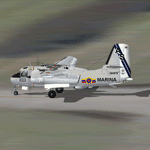
Grumman S2-E Tracker c/n 149878, registration ARV-103, as a part of the Antisubmarine Squad, (Escuadrilla Antisubmarina), Escuadron Aeronaval of the Marina de Venezuela, This aircraft had a long service with this unity, being retired in the 90's. Textures only for the Perfect Flight Grumman
S2-A/E Tracker (payware package), by Massimo Taccoli and Stefano Caputo,(see at http://www.fs2000.org/grumman/index.htm)
By Gustavo La Cruz and Juan Ernesto Oropeza.
| Filename: | Marina_de_Venezuela_Grumman_S2E_Tracker_ARV103.zip |
| License: | Freeware |
| Added: | 25th March 2010, 18:42:46 |
| Downloads: | 138 |
| Author: | Gustavo La Cruz - Juan Ernesto Oropeza |
| Size: | 2.78 MB |
| Category: Navigation and ATC - Navigation | |
| Chicago Sectional Chart Chunks for Aerosoft's FSMap |
|
File Description:
Sectional chart chunks made from the August 2009 Sectional charts at the original scale, formatted in the WGS84 lat/long geographic coordinate system for the FSMap, moving map application for flight simulation use. The chart chunks are the full sectional divided by 2 tiles (east/west) and converted to baseline 8bit tiffs with packbits compression applied. The images average 6,000x6,000 pixels at about 25mb each, also included is the FSMap fsm Calibration file for importing.
| Filename: | Chicago_Sectional_Chart_Chunks_for_Aerosofts_FSMap.zip |
| License: | Freeware |
| Added: | 22nd March 2010, 20:40:31 |
| Downloads: | 516 |
| Author: | David Myers |
| Size: | 31.9 MB |


© 2001-2026 AVSIM Online
All Rights Reserved
Privacy Policy |