
Where Flight Simulation Enthusiasts Gather from Around the World!
AVSIM Library - Search Results

| Category: Flight Simulator X - Scenery | |
| Joint Base Mc Guire Dix Lakehurst Airport (KWRI) |

|
File Description:
View the ReadMe file for details. Scenery constructed with use of satellite images/streetview/aerial photos - the author has not been there in person. This scenery is meant to be used in conjunction with MegaScenery Earth New Jersey/Delaware 002. It is not required, but apron use is minimized to allow satellite scenery to show through as much as possible, and objects are placed based on the MSE textures - lack of it may make scenery look out of place.
| Filename: | Joint_Base_Mc_Guire_Dix_Lakehurst_Airport_KWRI.zip |
| License: | Freeware |
| Added: | 4th June 2012, 01:18:43 |
| Downloads: | 1,028 |
| Author: | Drew Sikora |
| Size: | 24.06 MB |
| Category: Flight Simulator X - Panels | |
| HUD Gunsight for Mirage III/5 |
|
Images related to this file:
File Description:
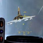
HUD Gunsight for the Skysim FSX Mirage III/5.
As good as the HUD is in the Skysim FSX Mirage III/5 package it is better applied to a more modern fighter, not one developed in the 1960s. It is more of the style that was added to some Mirage III/5 during their mid-life modernization upgrades -- the original gunsight was much more simplified. So I have made a new gunsight to replace it. It is based on the C.S.F. 97K optical sight as detailed in the Mirage IIIE Flight Manual.
| Filename: | HUD_Gunsight_for_Mirage_III5.zip |
| License: | Freeware, limited distribution |
| Added: | 18th November 2009, 12:14:23 |
| Downloads: | 424 |
| Author: | Frank Safranek |
| Size: | 350.9 KB |
| Category: Flight Simulator X - AFCAD Files | |
| Woodbine Municipal Airport (1N4), NJ |
|
File Description:
Located 02 miles SE of Woodbine, New Jersey on 700 acres of land, Woodbine Municipal Airport serves small to large GA craft as well as gliders and ultralights. Tie downs are the only option for transient aircraft. The main parking area of the airport is located in the center tarmac area near the fuel station. The parking spots can accomodate aircraft with wingspans up to 50 feet. Anything larger should park off the side of the taxiway. Fuel is available by stopping near the fuel tank. It should be noted that this airport's real ICAO is KOBI.
Scenery constructed with use of satellite images/streetview, the author has not been there in person.
This scenery is meant to be used in conjunction with MegaScenery Earth New Jersey/Delaware 005. It is not required, but apron use is minimized to allow satellite scenery to show through as much as possible, and objects are placed based on the MSE textures - lack of it may make scenery look out of place.
| Filename: | Woodbine_Municipal_Airport_1N4_NJ.zip |
| License: | Freeware |
| Added: | 22nd October 2010, 06:03:35 |
| Downloads: | 202 |
| Author: | Drew Sikora |
| Size: | 352.7 KB |
| Category: Miscellaneous Files - Demos from Commercial Vendors | |
| Eurofighter Panel New |
|
File Description:
New Eurofighter Panel, www.afs-design.de, Freeware for FS2004.
NEW Panel, NEW Eurofighter GAUGES:
MFD 1: radar, MFD 2: DASS, MFD 3: weather radar, MFD 4: engines,MFD 5: fuel,
MFD 6: multifunctionsgauge, MFD 7: autopilot, MFD 8: radios, MFD 9: new GPS HSI,
And new Gauges: 4 HUD's, exit and statusgauges AND signaturegauges of: Eurofighter,
A380, Eurocopoter Tiger, Sukhoi 35, F-22,tank
by www.afs-design.de - Author: A.Meyer.
| Filename: | Eurofighter_Panel_New.zip |
| License: | Commercial demo |
| Added: | 18th March 2006, 14:34:16 |
| Downloads: | 3,635 |
| Author: | Andreas Meyer |
| Size: | 3 MB |
| Category: Flight Simulator X - AFCAD Files | |
| Guntersville Municipal Airport 8A1 |
|
File Description:
Guntersville Municipal Airport 8A1, also known as Joe Starnes Field, is an airport located three miles northeast of Guntersville, Alabama. The scenery adds the new runway 7-25 and closes the old runway 3-21. It also adds the water runway 6W-24W, and the new tarmac with a small amount of hangers. The buildings are placed as close to real world locations as I could get using Google Earth. Only generic FSX objects were used for ease of distribution. The file has been tested with Ultimate terrain and MegaSceneryEarth Alabama can be edited with ADE
| Filename: | Guntersville_Municipal_Airport_8A1.zip |
| License: | Freeware |
| Added: | 6th July 2017, 18:32:00 |
| Downloads: | 91 |
| Author: | Brad Banister |
| Size: | 5.94 KB |
| Category: Prepar3D V5 - AI Aircraft | |
| P3DV4-5 Raven FS Labs CRJ-900 SAS new colors |
|
Images related to this file:
File Description:
Textures only for Raven FS Labs Bombardier CRJ-900 with PBR textures. Included registrations for real traffic. Painted by Joel Branchu. Apr 2022
| Filename: | P3DV45_Raven_FS_Labs_CRJ900_SAS_new_colors.zip |
| License: | Freeware |
| Added: | 24th April 2022, 20:46:02 |
| Downloads: | 148 |
| Author: | Joel Branchu |
| Size: | 943.44 KB |
| Category: Flight Simulator X - AFCAD Files | |
| High Meadow Farms Airport (9NJ8), NJ |
|
File Description:
Located 02 miles SW of Hope, New Jersey on 88 acres of land, High Meadow Farms Airport is a private turf strip 1850' in length. Take notice that the traffic pattern for Runway 13 is Right while the pattern for Runway 31 is Left. There is no hard surface runway so have your terrain mesh set as high as possible. There is tie down space available next to the paved area by the other parked aircraft however there are no official services offered for transient aircraft. This is a great airport to depart from to see some nice hilly terrain in northern NJ, it is just a few miles from the Delaware River Water Gap.
Scenery constructed with use of satellite images/streetview/aerial photos - the author has not been there in person.
This scenery is meant to be used in conjunction with MegaScenery Earth New York 007. It is not required, but apron use is minimized to allow satellite scenery to show through as much as possible, and objects are placed based on the MSE textures - lack of it may make scenery look out of place.
| Filename: | High_Meadow_Farms_Airport_9NJ8_NJ.zip |
| License: | Freeware |
| Added: | 7th April 2011, 00:16:49 |
| Downloads: | 200 |
| Author: | Drew Sikora |
| Size: | 641 KB |
| Category: Flight Simulator X - AFCAD Files | |
| Weiss Farm Airport (JY24), NJ |
|
File Description:
Located 02 miles W of Allamuchy, New Jersey on 264 acres of land, Weiss Farm Airport is a private turf strip 1800' in length. The published width is 50' but you really have closer to 100' to play with. There are no services offered to transient aircraft but you can start parked next to the barn if you wish to taxi out to the runway. No hard surfaced runway is used to have your terrain mesh set as high as possible the start of Runway 23 is a bit slanted and bumpy so you may want to aim long on your approach. The airport is unlit so daytime VFR operations only are recommended.
Scenery constructed with use of satellite images/streetview/aerial photos - the author has not been there in person. This scenery is meant to be used in conjunction with MegaScenery Earth New York 007. It is not required, but apron use is minimized to allow satellite scenery to show through as much as possible, and objects are placed based on the MSE textures - lack of it may make scenery look out of place.
| Filename: | Weiss_Farm_Airport_JY24_NJ.zip |
| License: | Freeware |
| Added: | 21st April 2011, 10:09:59 |
| Downloads: | 192 |
| Author: | Drew Sikora |
| Size: | 593.91 KB |
| Category: Flight Simulator 2004 - AI Flight Plans | |
| Air Southwest Jan-Dec 2008 |
|
File Description:
These are flight plans for Air Southwest a regional carrier that operates 5 Dash 8Q300 Aircraft.
Airsouthwest is a low cost carrier that operates from Plymouth Newquay And Bristol. And with routes that span top France, Scotland, Ireland And the United Kingdom. These flight plans are 100% accurate with flights to all 5 new destinations from Plymouth.
These are the aircraft required. (fsp_dash8_300_air_southwest_fleet.zip ) and ( fsp_dash8_300_air_southwest.zip )
| Filename: | Air_Southwest_JanDec_2008.zip |
| License: | Freeware, limited distribution |
| Added: | 1st April 2008, 16:24:05 |
| Downloads: | 743 |
| Author: | Piran Smith |
| Size: | 3.35 KB |
| Category: Flight Simulator 2004 - Aircraft Repaints, Textures and Modifications | |
| RAAF Avro York MW140 |
|
File Description:
textures for Classic British Flight Sim avro york. First Flight 10/11/44. Delivered RAF 246 Sqn 09/02/45. Transfered to RAAF as 'Endeavour' and allocated A74-1 10/03/45. To 1 AD 19/03/45. To Governor Generals Flight 02/04/45. To 17 RSU for engine change 10/04/45. To Governor Generals Flight 11/04/45. Although the RAAF identification number A74 was allocated, the York retained the original serial MW140, but the RAF markings were exchanged for the contemporary RAAF blue and white roundels and flashes. The York was used for long-range flights including the Duke's tour of New Guinea, New Britain, and Bougainville Island. The flight was terminated on July 5 1945, because of the death of the Prime Minister, the Rt Hon John Curtin. On two occasions, September 20 1945, and October 5 1945 "Endeavour" was flown to Singapore to evacuate ex-POWs, and on the first return journey a record flight was established between Perth and Canberra. On January 17 1947, "Endeavour" departed from Mascot and arrived in England on January 23 1947, where the aircraft was handed back to the Air Ministry. 06/01/48, RAF 24 Sqn. 03/52, Withdrawn & stored RAF 12MU Kirkbride, Cumbria, UK, 07/09/54 Aviation Jersey - later broken up. Although allocated A74-1, it was never applied to the aircraft
| Filename: | RAAF_Avro_York_MW140.zip |
| License: | Freeware |
| Added: | 1st July 2008, 13:14:52 |
| Downloads: | 280 |
| Author: | matt levi |
| Size: | 656.77 KB |


© 2001-2026 AVSIM Online
All Rights Reserved
Privacy Policy |