
Where Flight Simulation Enthusiasts Gather from Around the World!
AVSIM Library - Search Results

| Category: Flight Simulator 2004 - Scenery | |
| Buochs, Switzerland - LSZC |

|
File Description:
I created more improvement detail in this airport and found out that the formerly code was LSMU and now changed new code LSZC.
| Filename: | Buochs_Switzerland__LSZC.zip |
| License: | Freeware |
| Added: | 19th December 2020, 20:18:33 |
| Downloads: | 215 |
| Author: | Stuart John Gilbert II |
| Size: | 2.1 MB |
| Category: Prepar3D V1-4 - Aircraft Repaints, Textures and Modifications | |
| Gulf Air Boeing 787-9 A9C-FF |
|
Images related to this file:
File Description:
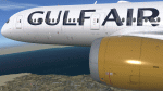
Gulf Air livery for QualityWings Boeing 787-8. Works in FSX and P3Dv5. See more repaints and updated versions in www.texturasbrasileiras.blogspot.com or www.texturasbrasileiras.com.
| Filename: | Gulf_Air_Boeing_7879_A9CFF.zip |
| License: | Freeware |
| Added: | 27th September 2021, 00:35:12 |
| Downloads: | 330 |
| Author: | Gustavo Aguiar |
| Size: | 29.19 MB |
| Category: Flight Simulator X - Original Aircraft | |
| FSX Egyptair Boeing 787-9 AGS V6.5. |
|
Images related to this file:
File Description:

FSX Egyptair Boeing 787-9 AGS V6.5.
Ground animations and vehicles have all been upgraded.
Model design and paint by Camil Valiquette. ( CamSim )
| Filename: | FSX_Egyptair_Boeing_7879_AGS_V65.zip |
| License: | Freeware |
| Added: | 18th November 2020, 19:37:43 |
| Downloads: | 113 |
| Author: | Camil Valiquette |
| Size: | 10.98 MB |
| Category: Flight Simulator 2004 - Utilities | |
| Traffic Manager v1.0d |
|
File Description:
With Traffic Manager you can organize, compile, decompile, create, import and export AI flight plans and routes. This file replaces all previous versions.
| Filename: | Traffic_Manager_v10d.zip |
| License: | Freeware, limited distribution |
| Added: | 12th July 2004, 22:15:06 |
| Downloads: | 14,059 |
| Author: | Vanderlei Martinelli |
| Size: | 2.67 MB |
| Category: Flight Simulator 2004 - Scenery | |
| El Formosa - Taiwan Scenery Project, Part 10 |
|
Images related to this file:
File Description:
Taiwan Kaohsiung International Airport (RCKH) and Kaohsiung City landmarks. Require el Formosa - Taiwan Scenery Project Part 1, 3, 4, 6, 7, and 8.
| Filename: | El_Formosa__Taiwan_Scenery_Project_Part_10.zip |
| License: | Freeware, limited distribution |
| Added: | 24th October 2010, 18:50:10 |
| Downloads: | 8,890 |
| Author: | Formosa Group |
| Size: | 13.87 MB |
| Category: Flight Simulator 2004 - Scenery | |
| El Formosa - Taiwan Scenery Project, Part 2 Patch |
|
File Description:
This patch will replace RCWA 3D fence by textured 2D fence to have better FPS performance.
And update RCCM building and all AFCAD.
| Filename: | El_Formosa__Taiwan_Scenery_Project_Part_2_Patch.zip |
| License: | Freeware, limited distribution |
| Added: | 27th February 2006, 00:33:13 |
| Downloads: | 10,763 |
| Author: | Rudolf Liu |
| Size: | 1.11 MB |
| Category: Flight Simulator 2004 - Scenery | |
| Bethel PABE in southwest Alaska |
|
Images related to this file:
File Description:
There are four main northwestern Alaska towns which have good airports and are serviced by Alaska Airlines. From these airports local flights connect to nearby villages, "nearby" in Alaska meaning up to 200 miles away. The northernmost is Barrow. Southwest of Barrow is Kotzebue, then Nome, and the furthest south is this one, Bethel. The town of Bethel has a population of just over 6,000 and is 50 miles from the sea on the Kuskowim River, that splits and forks into many tributaries. Bethel Airport is close to the town and provides the only contact with the rest of Alaska, as there is no connecting highway system. There are scheduled flights by Alaska Airlines, ERA (now called Ravn) and Grant Aviation, plus others such as Ryan Air. There are cargo flights by Everts, Northern, and Lynden, and redistribution onwards to nearby villages by the smaller locally-based planes; all of these are included in the AI. There are two main runways, one just under 6,400 feet and another just under 3,900 feet, both of them aligned 19-1. The third runway is around 1,800 feet and mainly gravel, aligned 11-29. Parking at PABE is on three aprons, the northern for smaller commercial planes of Grant, ERA, Ryan etc, the central for larger planes of Alaska, Northern, Everts, and Lynden, and the southern for a large collection of GA; each apron has further hangars for maintenance companies and smaller operators. There is also another separate apron for the local military and Coastguard. There is not much photographic information available for PABE, and I have never been there; as a result it was impossible to make detailed photographic textures for some of the buildings. However, for most hangars I have made textures of at least the right colour etc based on the information I assembled and if it is green with white trim and side windows then that is how it now appears here. The exceptions are the Alaska Airlines terminal building which has complicated curved elements, and the two military hangars and workshops where I had to settle for an Alaska terminal building from another airport and the same for the military. There are numerous small villages in the vicinity of Bethel, all of them being beside either a river tributary or the coast. There are two Google Earth screenshots to show the villages that are served by the flights from Bethel and that are (mostly) included in the AI. Some of these airfields were not included in FS9 but AI will still operate in and out of Bethel. The smaller area screenshot shows the villages that are close to Bethel, and of these eight I have so far made six and they are included in this post: Napaskiak PKA, Napakiak WNA, Kwethluk KWT, Atmautluak 4A2, Nunapitchuk 16A, and Kasigluk Z09. I will work my way through the rest of the area.
| Filename: | Bethel_PABE_in_southwest_Alaska.zip |
| License: | Freeware, limited distribution |
| Added: | 8th March 2019, 00:37:58 |
| Downloads: | 309 |
| Author: | Roger Wensley |
| Size: | 32.02 MB |
| Category: Prepar3D V1-4 - Aircraft Repaints, Textures and Modifications | |
| VARIG 1998 |
|
File Description:
In 1998, VARIG was still a huge legacy airline, but routes and frequencies were starting to be cut, which continued into the 2000s until their 2006 demise. MD-11s, DC-10-30s, and 747-300s mostly served long-haul routes such as NGO, NRT, LAX, MIA, JFK, MAD, BCN, LHR, CPH, ect, while the 767s did longer South America routes as well as CUN/MEX/JFK/MCO/MIA as well as flights to Spain and Portugal. VARIG's "around the world" GIG-GRU-JNB-BKK-HKG-BKK-JNB-CPT-GRU-GIG flight was flown with an MD-11 at the time, and I have assigned it to the "World Cup" livery MD-11, which means you will not see the aircraft much in Brazil but it will pop up abroad. VARIG flew many "tag on" flights, like LIM-LAX-NRT/NGO, LHR-CPH, MAD-BCN, MIA-MCO, ect, and there are many, many GIG-GRU and GRU-GIG flights that were part of international routes with no ticket sales in between. Between 0500 and 0700, there are many widebodies making this short flight. The 737-300s flew all over Brazil and to some South American countries. Rio Sul, who did the flights to CGH and SDU, is not included was released seperately on Avsim as "rio_sul_1998.zip". Though VARIG livery 737-300s flew on behalf of Rio Sul, Nordeste and PLUNA, those flights are not included and are included in those respective airlines. An MD-11 and a 737-300 were painted in special colors to celebrate the World Cup, and a 767-200 wore a special Star Alliance livery. The 747-300 in the Star Alliance colors only had them applied to one side of the aircraft and never flew revenue service in that livery, so it is not included. The rest of the fleet wore a mix of the 1997 introduced livery and the 1980s blue and white colors with the silver belly. The entire fleet on the FAIB 737-200, 737-300, 747-300, 767-200 and 767-300,and FSPX MD-11 by Raphael Rodrigues is included. The DC-10-30s on the AIM model by Jason King are on Avsim as "aim_dc1030_varig_pp-vmb_313514.zip" and "aim_dc1030_varig_oldcolors_307373.zip". Flightplans by Chasen Richardson. Part of the 1998 Flight Simulator Project. Follow us on Facebook at facebook.com/flightsim98 and on instagram as @bayviationsim. For more Retro AI, check out the forums at: http://retroai.proboards.com/
| Filename: | VARIG_1998.zip |
| License: | Freeware, limited distribution |
| Added: | 1st January 2020, 20:13:56 |
| Downloads: | 621 |
| Author: | Raphael Rodrigues, Chasen Richardson\ Bayviation |
| Size: | 30.59 MB |
| Category: Flight Simulator 2004 - Scenery | |
| E T Joshua TVSV on Saint Vincent in the eastern Caribbean |
|
Images related to this file:
File Description:
Saint Vincent island is the northernmost of the group of islands known as St Vincent and the Grenadines, just south of St Lucia. St Vincent is around 17 miles long and 10 miles wide and by far the largest in the group, and the islands have a total population of around 120,000. E T Joshua is at the southern end of the island, adjacent to the capital Kingstown. There is a new airport under construction a few miles to the east which will have a longer runway and a larger apron, and when it is ready E T Joshua will probably be closed and redeveloped.
The terminal and the other smaller buildings are all made with photographic textures; the terminal is now quite old and has seen better days. The airport is a hub for small local airlines and also has regular LIAT flights connecting to other islands. The runway is just a shade under 4,700 feet of asphalt, so there are no direct flights from Europe. The new airport to the east is depicted as under construction; obviously I have not flown there and I have not tried to depict the terminal building which is also under construction but a mystery to me.
| Filename: | E_T_Joshua_TVSV_on_Saint_Vincent_in_the_eastern_Caribbean.zip |
| License: | Freeware, limited distribution |
| Added: | 11th June 2013, 16:29:42 |
| Downloads: | 536 |
| Author: | Roger Wensley |
| Size: | 3.13 MB |
| Category: Flight Simulator X - Scenery | |
| Aeroworks Railroad Valley 2013 |
|
Images related to this file:
File Description:
Railroad Valley is our oldest scenery project and by far the largest. It was originally released for FS2000 and version 2 was used in the Battle of the Airlines 2003 online race. It is a follow on to our series of fictional airports and surrounding areas that we call Flight Centers, such as our popular Malibu Flight Center 2. Included in the package is our centerpiece - Flight Center 3 at Echo Canyon and Flight Center 4 at Lunar Lake. Flight center 3 is our prime military headquarters, and functions as an aircraft manufacturing and flight test center all in one. It's much like a combined version of Edwards AFB and Palmdale Air Force Plant 42 in real life. Flight Center 4 is loosely based off of the High-technology Aerospace Warfare Center (or HAWC) from the earliest Dale Brown novels. The bases lie roughly 50 miles north of Area 51, Groom Lake, Nevada, and are just outside of the Nevada Test Site and the Nellis Air Force Range. In addition there are many other airports and flying locales too numerous to mention here. Full documentation contained within. Uses over 100 custom scenery macros specifically created for this release. Scenery and macros by Jason L. Terry. Additional Macros by Joshua B Nyhus.
| Filename: | Aeroworks_Railroad_Valley_2013.zip |
| License: | Freeware |
| Added: | 27th September 2013, 20:40:07 |
| Downloads: | 436 |
| Author: | Jason L. Terry |
| Size: | 29.71 MB |


© 2001-2026 AVSIM Online
All Rights Reserved
Privacy Policy |