
Where Flight Simulation Enthusiasts Gather from Around the World!
AVSIM Library - Search Results

| Category: Flight Simulator 2002 - Original Aircraft | |
| Pro ANG Lockheed C-130E MAFFS Hercules |

|
File Description:
FS2002 Pro ANG Lockheed C-130E MAFFS Hercules. Modular Airborne Fire Fighting System equipped for fighting forest fires. ANG Tail Number 62-1851. Operating from the 146th Airlift Wing, Channel Island Air National Guard Station, California, USA.Please check the readme file on installing the FX File needed for the MAFFS Effect. FS2002 Std Users can use this plane by changing the panel to one of the C130 panels available on the net.
Design and Paint by Barry Blaisdell (PAD), Flight Dynamics by Jens Borgstroem
| Filename: | Pro_ANG_Lockheed_C130E_MAFFS_Hercules.zip |
| License: | Freeware, limited distribution |
| Added: | 4th August 2002, 21:45:06 |
| Downloads: | 2,442 |
| Author: | Premier Aircraft Design |
| Size: | 319.75 KB |
| Category: Flight Simulator X - Scenery | |
| RAF Catterick |
|
File Description:
RAF Catterick is located alongside the A1 on the outskirts of Catterick Village. Operationally it falls under the command of Catterick Garrison. It currently houses 5th Regiment Royal Artillery and 32 Engineer Regiment.
Catterick airfield first opened in 1914 as a Royal Flying Corps aerodrome with the role of training pilots and to assist in the defence of the North East of England. It came under RAF administration in 1918 and housed Number 49 Training Depot.
In 1927, it temporarily came under the administration of the British Army, under the Army Air Co-Operation Command which would supply the army with any air support needs that would be required. This continued until 1939 when the station was handed back to the RAF.
During the Second World War, the airfield operated a small satellite station called RAF Scorton near the village of Scorton.
Catterick's runway could not be extended from its existing 3,350 ft (1,020 m) for the jet age due to the perimeter being bounded by the Great North Road (A1) and the River Swale. Therefore, Catterick's importance declined after the Second World War, though it still housed training institutes for many years.
Source:Wikipedia
| Filename: | RAF_Catterick.zip |
| License: | Freeware |
| Added: | 18th February 2017, 19:17:37 |
| Downloads: | 128 |
| Author: | Terry Boissel |
| Size: | 1.91 MB |
| Category: Flight Simulator X - Scenery | |
| Pichlingersee - LOW1 |
|
Images related to this file:
File Description:
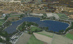
The Pichlingersee (LOW1) is a quarry pond near Linz (LOWL) in Austria (Upperaustria). The ILS approach to the runway 27 cross this lake. The helipad is in possession of Water Rescue Department and was not build on land. It was build "in water".
For the implementation of this area about 500 objects were set by hand from myself. Including not only trees and shrubs, but also signs, park benches, emergency call boxes (gernerated in gmax) etc at there right place. At night it was dark in real, so I does not create night texture. The scenery has 1.5 km ground imagery at 20cm per pixel and vary (hope) with the seasons.
Der Pichlingersee ist ein Baggersee in der Nhe von Linz (LOWL) in sterreich (Obersterreich). Der ILS Anflug auf die Landebahn 27 fhrt genau ber diesen See. Die Hubschrauberplattform gehrt der dortigen Wasserrettung und wurde nicht auf dem Land, sondern in den See hinein gebaut.
Fr die Umsetzung des Areals wurden von mir ber 500 Objekte von Hand gesetzt. Darunter nicht nur Bume und Strucher, sondern ebenso Schilder, Parkbnke, Notrufsulen (in gmax generiert) usw. an ihrem richtigen Platz. Da es dort in der Realitt nachts stockdunkel ist, habe ich auf Nachttexturen verzichtet. Die Szenerie hat eine 1.5 km Bodentextur mit 20cm/px und wechselt (hoffentlich) mit den Jahreszeiten.
| Filename: | Pichlingersee__LOW1.zip |
| License: | Freeware |
| Added: | 9th January 2013, 00:44:19 |
| Downloads: | 1,997 |
| Author: | Oliver Brandl |
| Size: | 54.71 MB |
| Category: Flight Simulator 2004 - Utilities | |
| TDFCalc2004 |
|
File Description:
This package is for FS2004 and FS2002 terrain designers. TDFCalc2004 is made for use with FSUIPC and FS2004. This is a version that includes true heading readings. It is an FSUIPC registered freeware program that requires version 3.? of FSUIPC.dll installed to the FS2004 Module folder. FSUIPC is a vailable on the internet, and this program requires an application registration entered within FSUIPC. Usage with FS2002 or CFS2 requires no registration with the older versions of FSUIPC. LandCalc and TDFCalc2 are small programs which require the input of Latitude and Longitude, in 'DD:MM.decimal' format. Landcalc returns the names of the "CUSTOM" textures required by photoreal ( CUSTOM ) BGLs, and LandClass BGLs ( using values #253 or #252 ). TDFCalc2 returns valuable information concerning the X, Y coordinates needed for the creation of LWM and VTP polygons/lines. TMFViewerCalc requires input as Decimal Degrees.
| Filename: | TDFCalc2004.zip |
| License: | Freeware |
| Added: | 6th September 2003, 21:12:04 |
| Downloads: | 1,728 |
| Author: | Richard Ludowise |
| Size: | 926.3 KB |
| Category: Flight Simulator 2004 - Utilities | |
| Active AirSource v3.27 Full Install |
|
File Description:
Active AirSource (AAS) is a small stand-alone program that runs while you fly Microsoft Flight Simulator (FS2000, FS2002, FS2004). It records and sends data from Flight Simulator directly to the AirSource website (http://air-source.us) via the use of FSUIPC module and Microsoft's MSINET.dll. This functionality will allow pilots to fly and be seen on the Active AirSource flight boards. In addition, pilots will be able to increase their v-salary by filing their flights as "AAS Certified", since flights are verified through the program as "authentic flight time". Active AirSource (or AAS) runs in either multiplayer OR single player mode in Flight Simulator.
If you want more information about this Active AirSource program, you can visit the following webpage; About AAS
| Filename: | Active_AirSource_v327_Full_Install.zip |
| License: | Freeware |
| Added: | 17th October 2004, 20:43:50 |
| Downloads: | 10,204 |
| Author: | John McCormack |
| Size: | 9.36 MB |
| Category: Orbiter - Spaceships | |
| Saturn V Crawler Rollout version 10.. |
|
File Description:
This is the Saturn V VAB to Launch Centre Crawler version 10 with the NASSP 5.0 Apollo 11 attached...High detail (High Polygon Count)...Not For Low End Computers..The Saturn V Mesh is included because it needed to be rotated 90', but the Module and Textures are not included so the NASSP ver 5.0 must be downloaded and installed first before you install this add-on,it can be found at ( http://spacebarjoe.free.fr/NASSP5.zip ), the mesh names are changed so it will not overwrite.Press CTRL and Minus on the numpad to get rolling, throttle back to maintain a velocity of 1..In Scenario 4 use K to operate the Crane and G to operate the Gangway and Swingarms.Uses Vinka's Spacecraft2.DLL(included)...Needs OrbiterSound 3.0 or higher installed and the latest Orbiter Version and Patch.
| Filename: | Saturn_V_Crawler_Rollout_version_10.zip |
| License: | Freeware |
| Added: | 24th August 2005, 19:11:58 |
| Downloads: | 1,242 |
| Author: | Kev Shanow |
| Size: | 3.63 MB |
| Category: Flight Simulator X - Utilities | |
| paX Passenger Simulation |
|
File Description:
You might use professional airliner add-ons (or even the default airliners), are flying under realistic conditions, maybe you have even installed a sound effects panel for passenger announcements, but still something’s missing – the passengers!
paX aims at being a complete passenger simulation/emulation environment for your flights. At the moment, a boarding simulation module is available that accurately simulates boarding passengers while fully integrating into FSX (and only into FSX, SP1 and up). Several configuration options for passenger behavior, aircraft capacity and boarding methods are available, while real-world occurrences (like passengers blocking aisles or arriving late or not at all) are modelled into the program. paX is synced to your FSX flight time and supports time compression (simulation rates) and the simulator pause command.
Pre-configured aircraft definition files for all default airliners (in several cabin configurations) are also included.
| Filename: | paX_Passenger_Simulation.zip |
| License: | Freeware |
| Added: | 26th July 2008, 15:59:22 |
| Downloads: | 9,646 |
| Author: | Henning Schaefer |
| Size: | 1.11 MB |
| Category: Flight Simulator X - Panels | |
| RAF Cammeringham |
|
File Description:
RAF Cammeringham (formerly RAF Ingham) was a Royal Air Force station used by RAF Bomber Command between 1940 and 1945 and the Polish Air Force until 1946. The airfield was located between the A15 (Ermine Street) and B1398 roads, 10.3 mi (16.6 km) north of the county town Lincoln, Lincolnshire, England and due east of the village of Ingham.
Mainly used as an overflow airfield for nearby RAF Hemswell and later as a training establishment, its continued use was limited by damage to its grassed runways. The airfield closed in early December 1946.
| Filename: | RAF_Cammeringham.zip |
| License: | Freeware |
| Added: | 19th October 2015, 11:01:21 |
| Downloads: | 202 |
| Author: | Terry Boissel |
| Size: | 13.17 KB |
| Category: Prepar3D V1-4 - Scenery | |
| Valberg Guillaumes Francia N44.05.45 E6.55.44 |
|
Images related to this file:
File Description:
Valberg Guillaumes Francia N44.05.45 E6.55.44 is a ski resort located on the common Guillaumes, Peon and Beuil in the department of Alpes-Maritimes (region Provence-Alpes-Côte d'Azur). The station itself located in the geographical area of the Alps south and stretches from the massif of the Mont Mounier (2,817 m), to the north, to that of the Dome de Barrot (2,136 m), to the south.Important VFR point for approaching airport to Nice Airport and Airport Cuneo.
Within the downloaded package you will find readme files for scenery installation. Good fly VFR. Pasquale Marrulli.
| Filename: | Valberg_Guillaumes_Francia_N440545_E65544.zip |
| License: | Freeware |
| Added: | 10th December 2017, 07:45:03 |
| Downloads: | 129 |
| Author: | Pasquale Marrulli |
| Size: | 2.28 KB |
| Category: Flight Simulator X - Scenery | |
| RAF Bardney |
|
File Description:
RAF Barney is a former Royal Air Force station located 1.7 miles (2.7km) north of Bardney, Lincolnshire, England and 10.2 miles (16.4km) east of the County town of Lincoln. It was built as a satellite to RAF Waddington in 1943 and the airfield closed in 1963.
I would like to give credit and to acknowledge the following authors without whose work I could not have made this scenery; all credit for the models contained in it is theirs I merely placed it. Ted Andrews - Ian Pearson - Mike Hudson.
| Filename: | RAF_Bardney.zip |
| License: | Freeware |
| Added: | 3rd October 2015, 18:49:54 |
| Downloads: | 466 |
| Author: | Terry Boissel |
| Size: | 334.31 KB |
© 2001-2026 AVSIM Online
All Rights Reserved
Privacy Policy |