
Where Flight Simulation Enthusiasts Gather from Around the World!
AVSIM Library - Search Results

| Category: Prepar3D V1-4 - Scenery | |
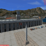
| P3D v4.3 Aeropuerto Internacional Alejandro Velasco Astete-PERU |

|
Images related to this file:
File Description:
ONLY FOR P3D V4.3
REQUIRES ANY TERRAIN MESH
Alejandro Velasco Astete International Airport (IATA: CUZ, ICAO: SPZO) is an international airport located in the city of Cusco, in southeastern Peru. Cusco, a principal tourist attraction in Latin America, receives various domestic flights as well as some international flights. The runway is completely paved. It operates at limited capacity due to its precarious location near the city's center. Despite these limitations, the airport has consistently ranked as Peru's second most important air terminal, handling 3,209,153 national and international passengers in 2016, as reported by CORPAC.
| Filename: | P3D_v43_Aeropuerto_Internacional_Alejandro_Velasco.zip |
| License: | Freeware |
| Added: | 15th June 2019, 22:52:35 |
| Downloads: | 1,741 |
| Author: | Jhon Cristian |
| Size: | 115.91 MB |
| Category: Flight Simulator 2002 - Scenery | |
| VLLN Airport Correction |
|
File Description:
Little correction for VLLN airport in my Laos airports pack
There is corrected elevation from 2440 to 3080ft, to be fit to surround mesh.
Please correct also airports.txt file with included item.
| Filename: | VLLN_Airport_Correction.zip |
| License: | Freeware |
| Added: | 28th August 2003, 16:19:33 |
| Downloads: | 249 |
| Author: | Vladimir Svoboda (Cesmina) |
| Size: | 3.58 KB |
| Category: Flight Simulator X - AFCAD Files | |
| KNFW - Fort Worth NAS JRB - Fort Worth, Texas - USA v2.3 |
|
Images related to this file:
File Description:
This is an update to my 2.1 release of 2012-01-05. Changes include renumbering main runway to 18-36, new Base Ops complex, relocated alert area, east POL facility, holding apron changes, new signage, new terrain scenery east of runway 36, and parking (including covered parking) for over 120 aircraft.
| Filename: | KNFW__Fort_Worth_NAS_JRB__Fort_Worth_Texas__USA_v23.zip |
| License: | Freeware |
| Added: | 1st November 2014, 00:54:48 |
| Downloads: | 1,271 |
| Author: | Allen Laughmiller |
| Size: | 31.02 KB |
| Category: Flight Simulator X - Scenery | |
| FSX/2004/FS2002 Whole Jordan ,Soaring Scenery |
|
File Description:
FSX/2004/FS2002 Whole Jordan ,Soaring Scenery
This file adds thermals lifts to glider´s flights over Whole Jordan Region,Middle East.
It is freeware.Good Flights and better Landings
Volta Redonda,Brazil,01/13/2008
Design:Francisco Vargas. E-mail:[email protected]
| Filename: | FSX2004FS2002_Whole_Jordan_Soaring_Scenery.zip |
| License: | Freeware |
| Added: | 13th January 2008, 16:53:34 |
| Downloads: | 264 |
| Author: | Francisco Augusto Vargas Carneiro |
| Size: | 635.46 KB |
| Category: Flight Simulator 2004 - Scenery | |
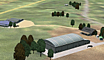
| Edinburgh Island, FOX-2, Horton River, Igloolik, & Kimmirut, adapted for the FSGenesis 76m North Canada Terrain Mesh |
|
Images related to this file:
File Description:
These are replacement bgl's to convert five northern Canada fields for use with the FSGenesis 76m terrain mesh for northern Canada. The five are Edinburgh Island CWEI, the FOX-2 DEW line station, Horton River CWHR, Igloolik CYGT, and Kimmirut CYLC. These are not stand-alone, and the presumption is that you have already downloaded and installed the previously posted sceneries. This installation consists solely of replacing the existing scenery bgl's with the new. There will be further posts of northern airfields in groups of five, alphabetically, and observations regarding the amendments and any further corrections that are required would be welcomed.
| Filename: | Edinburgh_Island_FOX2_Horton_River_Igloolik__Kimmi.zip |
| License: | Freeware, limited distribution |
| Added: | 10th September 2017, 19:29:57 |
| Downloads: | 86 |
| Author: | Roger Wensley |
| Size: | 3.55 MB |
| Category: Flight Simulator 2004 - Scenery | |
| Mandeville Aerodrome NZVL |
|
Images related to this file:
File Description:
Near Gore, New Zealand. Home of the Croydon Aircraft Company and several rare vintage aircraft. You must have Christian Stock's NZ mesh in the form of "Mountains of New Zealand" and topo in the form of "Lakes and Rivers of New Zealand".
| Filename: | Mandeville_Aerodrome_NZVL.zip |
| License: | Freeware |
| Added: | 28th June 2010, 03:40:26 |
| Downloads: | 375 |
| Author: | Godfrey Tier |
| Size: | 1009.27 KB |
| Category: Flight Simulator 2004 - Scenery | |
| Cromwell Racecourse - NZCS - Version2 |
|
Images related to this file:
File Description:
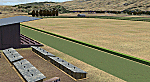
This replaces my previous version. Added racecourse hedge and finish-line. Also shifted some stables around. Made for Christian Stock's NZ mesh in the form of "Mountains of New Zealand"
and topo in the form of "Lakes and Rivers of New Zealand".
| Filename: | Cromwell_Racecourse__NZCS__Version2.zip |
| License: | Freeware |
| Added: | 4th December 2010, 23:59:32 |
| Downloads: | 292 |
| Author: | Godfrey Tier |
| Size: | 565.39 KB |
| Category: Flight Simulator 2004 - Scenery | |
| Mt Taranaki/Egmont, NZ, Photoreal Scenery |
|
File Description:
40 x 50 kilometres of photo-real scenery. Fully autogenned, daytime summer textures only. (It will display throughout the year though.)
This showcases the amazing volcanic Mt Taranaki. Like many New Zealand mountains it has both a Maori and European name. Mt Taranaki dominates the Taranaki landscape, and is a spectacular example of of how the central North Island has been effected by volcanic activity.
This is a remake of the original Godzone Taranaki scenery adjusted to match the new elevaton meshes. It is best with the Geographx 20m elevation mesh, and the minimum recommended mesh is the Geographx 75m.
| Filename: | Mt_TaranakiEgmont_NZ__Photoreal_Scenery.zip |
| License: | Freeware, limited distribution |
| Added: | 16th January 2006, 05:57:36 |
| Downloads: | 4,875 |
| Author: | Robin Corn |
| Size: | 40.09 MB |
| Category: Flight Simulator X - Miscellaneous Files | |
| FsGoogleEarthView v3.0 |
|
Images related to this file:
File Description:

FsGoogleEarthView enables Flight Simulator flight with realistic Google Earth view! With FsGoogleEarthView, you can take both - Google Earth's great photoreal ground, 3D Buildings, detailed terrain mesh and Flight Simulator's great flight model, flight instruments, add-on aircrafts, add-on airport sceneries - with no downloading and very short loading time, anywhere in the world! It will provide more enjoyable VFR flight than any other sceneries. Now with v3.0, additional functions such as VDGS, Landing Report, Airport Moving Map, Route Visualization and Flight Logging are also included. And it's freeware now. It works with FSX, FS2004, Prepar3d, X-plane all.
| Filename: | FsGoogleEarthView_v30.zip |
| License: | Freeware, limited distribution |
| Added: | 5th May 2017, 19:08:37 |
| Downloads: | 2,745 |
| Author: | Dongjin Shin |
| Size: | 14.9 MB |
| Category: Orbiter - Spaceships | |
| NASSP V 3.0 Saturn V |
|
File Description:
Saturn V Apollo/LEM Stack.
Featuring materials of AMSO Add-on.
- Full Flight lunar support
- Apollo 13 Failure
- Deep Space EVA
- Lunar EVA Enhanced Mesh by Rodion
| Filename: | NASSP_V_30_Saturn_V.zip |
| License: | Freeware |
| Added: | 5th December 2002, 02:55:16 |
| Downloads: | 8,593 |
| Author: | Jean-Luc Rocca-Serra (Joe_BAR) |
| Size: | 5.87 MB |
© 2001-2026 AVSIM Online
All Rights Reserved
Privacy Policy |