
Where Flight Simulation Enthusiasts Gather from Around the World!
AVSIM Library - Search Results

| Category: Flight Simulator X - Scenery | |
| British Columbia Floatbases |

|
Images related to this file:
File Description:
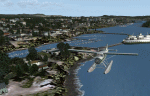
This is a collection of floatbases around the coast of British Columbia made with default scenery objects, and derived from Google Earth and the Canada Waterdrome Supplement. This scenery is designed to complement the work of others and therefore doesn't include waterdromes made by others such as Sidney Schwartz's CYYJ, Ganges Harbour and BCPNW Float Bases which covers an area around the Gulf Islands. You must have Ultimate Terrain Canada for these sceneries to work and in areas away from the immediate coast (Fraser River), a SRTM mesh for the correct elevations.
| Filename: | British_Columbia_Floatbases.zip |
| License: | Freeware |
| Added: | 16th May 2012, 14:02:09 |
| Downloads: | 1,537 |
| Author: | Chris Peschke |
| Size: | 183.32 KB |
| Category: Flight Simulator X - Scenery | |
| Mesh Correction |
|
File Description:
These files correct wrong shape of FSX mesh at Lagoa Santa and Governador Valadares, Minas Gerais, Brazil, fixing the elevation to the real height level.
| Filename: | Mesh_Correction.zip |
| License: | Freeware, limited distribution |
| Added: | 16th March 2007, 01:55:24 |
| Downloads: | 942 |
| Author: | Cesar Marinho |
| Size: | 134.9 KB |
| Category: Combat Flight Simulator 1 and 2 - Scenery | |
| Libya Mesh |
|
File Description:
Mesh of Libya for Cfs2 and FS2002
3 Arc-Second, LOD 10 mesh for the whole of Libya. Second Release. File 7 of 7
| Filename: | Libya_Mesh.zip |
| License: | Freeware, limited distribution |
| Added: | 13th May 2003, 12:25:28 |
| Downloads: | 349 |
| Author: | Josiah Haut |
| Size: | 20 MB |
| Category: Combat Flight Simulator 1 and 2 - Scenery | |
| Libya Mesh |
|
File Description:
Mesh of Libya for Cfs2 and FS2002
3 Arc-Second, LOD 10 mesh for the whole of Libya. Second Release. File 6 of 7
| Filename: | Libya_Mesh.zip |
| License: | Freeware, limited distribution |
| Added: | 13th May 2003, 12:25:04 |
| Downloads: | 367 |
| Author: | Josiah Haut |
| Size: | 19.39 MB |
| Category: Flight Simulator 2002 - Scenery | |
| Cornish Windfarms |
|
File Description:
This freeware demo is part of Nick Ryall SW England Landmark Scenery available from http://www.visualflight.co.uk/nickryall.
This scenery represents 7 Cornish windfarms in Cornwall UK, Goonhilly downs, Four Burrows, Carland cross,
Bears down, St Breock downs, Delabole and Cold Nortcott
The scenery has been designed primarily for use with addon VFR photographic scenery from Visual Flight and mesh terrain Lago's Terramesh for the UK.
It is part of a package which contains more than 50 VFR scenery Landmarks for the SW UK and is available for purchase at the Visual Flight website It does however work with Microsoft's default mesh terrain.
| Filename: | Cornish_Windfarms.zip |
| License: | Freeware |
| Added: | 10th March 2003, 16:12:55 |
| Downloads: | 1,668 |
| Author: | Nick Ryall |
| Size: | 2.28 MB |
| Category: Flight Simulator X - Scenery | |
| South America Mesh Scenery, MeshX_F3 |
|
File Description:
Mesh terrain scenery for the whole continental South America, based on SRTM 90m
dem geotiff files resampled to 76 meter of horizontal resolution (LOD 9).
The new files have improved the vertical resolution from 16m to 10m, resulting
in more details and accuracy over previous versions. There are 50 files, compatible
with FS9 and FS X, identified in a map by column letter and line number, covering the
contiguous countries and states. Boundaries: N = 0º 0' S; S = 5º 37.5' S;
E = 33º 45' W; W = 41º 15' W;
| Filename: | South_America_Mesh_Scenery_MeshX_F3.zip |
| License: | Freeware |
| Added: | 28th October 2006, 10:09:48 |
| Downloads: | 1,414 |
| Author: | Oséas Dourado and José Lôbo |
| Size: | 10.96 MB |
| Category: Flight Simulator X - Scenery | |
| South America Mesh Scenery, MeshX_D1 |
|
File Description:
Mesh terrain scenery for the whole continental South America, based on SRTM 90m
dem geotiff files,resampled to 76 meter of horizontal resolution (LOD 9). The new files have
improved the vertical resolution from 16m to 10m, resulting in more details
and accuracy over previous versions. There are 50 files, compatible with FS 9
and FS X, identified in a map by column letter and line number, covering the
contiguous countries and states. Boundaries: N = 11º 15' N; S = 5º 37.5' N;
E = 48º 45' W; W = 56º 15' W.
| Filename: | South_America_Mesh_Scenery_MeshX_D1.zip |
| License: | Freeware |
| Added: | 28th October 2006, 19:48:20 |
| Downloads: | 1,406 |
| Author: | Oséas Dourado and José Lôbo |
| Size: | 2.89 MB |
| Category: Flight Simulator X - Scenery | |
| South America Mesh Scenery, MeshX_D3 |
|
File Description:
Mesh terrain scenery for the whole continental South America, based on SRTM 90m
dem geotiff files resampled to 76 meter of horizontal resolution (LOD 9). The new files have
improved the vertical resolution from 16m to 10m, resulting in more details
and accuracy over previous versions. There are 50 files, compatible with FS 9
and FS X, identified in a map by column letter and line number, covering the
contiguous countries and states. Boundaries: N = 0º 0' S; S = 5º 37.5' S;
E = 48º 45' W; W = 56º 15' W.
| Filename: | South_America_Mesh_Scenery_MeshX_D3.zip |
| License: | Freeware |
| Added: | 28th October 2006, 19:50:25 |
| Downloads: | 1,476 |
| Author: | Oséas Dourado and José Lôbo |
| Size: | 38.77 MB |
| Category: Flight Simulator X - Scenery | |
| South America Mesh Scenery, MeshX_C5 |
|
File Description:
Mesh terrain scenery for the whole continental South America, based on SRTM 90m
dem geotiff files resampled to 76 meter of horizontal resolution (LOD 9). The new files have
improved the vertical resolution from 16m to 10m, resulting in more details
and accuracy over previous versions. There are 50 files, compatible with FS 9
and FS X, identified in a map by column letter and line number, covering the
contiguous countries and states. Boundaries: N = 11º 15' S; S = 16º 52.5' S;
E = 56º 15' W; W = 63º 45' W.
| Filename: | South_America_Mesh_Scenery_MeshX_C5.zip |
| License: | Freeware |
| Added: | 28th October 2006, 23:27:21 |
| Downloads: | 1,456 |
| Author: | Oséas Dourado and José Lôbo |
| Size: | 35.44 MB |
| Category: Flight Simulator X - Scenery | |
| South America Mesh Scenery, MeshX_C4 |
|
File Description:
Mesh terrain scenery for the whole continental South America, based on SRTM 90m
dem geotiff files resampled to 76 meter of horizontal resolution (LOD 9). The new files have
improved the vertical resolution from 16m to 10m, resulting in more details
and accuracy over previous versions. There are 50 files, compatible with FS 9
and FS X, identified in a map by column letter and line number, covering the
contiguous countries and states. Boundaries: N = 5º 37.5' S; S = 11º 15' S;
E = 56º 15' W; W = 63º 45' W.
| Filename: | South_America_Mesh_Scenery_MeshX_C4.zip |
| License: | Freeware |
| Added: | 28th October 2006, 23:27:57 |
| Downloads: | 1,441 |
| Author: | Oséas Dourado and José Lôbo |
| Size: | 39.66 MB |
© 2001-2026 AVSIM Online
All Rights Reserved
Privacy Policy |