
Where Flight Simulation Enthusiasts Gather from Around the World!
AVSIM Library - Search Results

| Category: Flight Simulator X - Scenery | |
| KHIB - Range Regional (Hibbing) Airport - Hibbing, Minnesota |

|
Images related to this file:
File Description:
FSX Scenery - Range Regional Airport (IATA: HIB, ICAO: KHIB, FAA LID: HIB) is a public use airport located four nautical miles (5 mi, 7 km) southeast of the central business district of Hibbing, in Saint Louis County, Minnesota, United States. It was formerly known as Chisholm-Hibbing Airport or Chisholm-Hibbing Municipal Airport. The airport is mostly used for general aviation but is also served by one commercial and one charter airline. Scheduled passenger service is subsidized by the Essential Air Service program. Created for your flying pleasure by John B. Loney, Jr.
| Filename: | KHIB__Range_Regional_Hibbing_Airport__Hibbing_Minn.zip |
| License: | Freeware, limited distribution |
| Added: | 29th July 2014, 11:43:33 |
| Downloads: | 496 |
| Author: | John B. Loney, Jr. |
| Size: | 15.58 MB |
| Category: Flight Simulator 2004 - AFCAD Files | |
| Madrid Barajas LEMD to default scenery |
|
File Description:
This is my second version of Madrid Barajas, I have activated runways 36L to take off and runway 33 to land. I use it with "Ultimate Traffic" and "My Traffic 2004" and it works perfectly, so I hope you to enjoy it. Esta es mi segunda version del aeropuerto Madrid Barajas, he activado la pista 36L para despegues y la 33 para aterrizajes. Yo lo uso con los dos programas de trafico artificial "Ultimate Traffic" y "My Traffic 2004" y funciona perfectamente, asi que espero que lo disfruteis. Un saludo.
| Filename: | Madrid_Barajas_LEMD_to_default_scenery.zip |
| License: | Freeware |
| Added: | 1st December 2004, 04:06:03 |
| Downloads: | 2,576 |
| Author: | Miguel Rama |
| Size: | 81.3 KB |
| Category: Flight Simulator 2004 - AI Aircraft | |
| USAF "171st & 191st Fighter Interceptor Squadrons" Convair F-106 Delta Dart |
|
File Description:
23 textures for the Convair F-106, 171st Fighter Interceptor Squadron/ 191st Fighter Interceptor Group,Selfridge Field ANG, MI.
I have included all of the squadrons 20 F-106A and the three F-106B's using Michael Pearson's excellent F-106 available here on AVSIM
(mpai_f106_traffic.zip). The 171st FIS/191st FIG "Six Pack" flew its first F-106A on 29 Dec 1972 and operated it until 16th August 1978.
The initial batch of 18 aircraft came from the 2nd FIS and consisted of 18 F-106A's and two F-106B's.
| Filename: | USAF_171st__191st_Fighter_Interceptor_Squadrons_Convair_F106_Delta_Dart.zip |
| License: | Freeware |
| Added: | 18th November 2014, 18:10:28 |
| Downloads: | 206 |
| Author: | Brian Sturrock |
| Size: | 5.21 MB |
| Category: Flight Simulator X - Scenery | |
| Gary Gale Seaplane Base - 0FL8 |
|
Images related to this file:
File Description:
Gary Gale Seaplane Base (0FL8) is a private seaplane base located in Florida, County: Duval, City: Jacksonville, GPS (Degrees): Lat: 30�° 11' 38'', Lng: -81�° 40' 55'', GPS (Seconds): Lat: 30.193889, Lng: -81.681944, GPS determination method: Estimated, Distance from central business district: 8 mi (SW). The scenery was made with ADE9X and is in the correct position according to satellite views. I added Seaplane docks, static seaplanes and a medium and small marina to make landing here more interesting. The real Seaplane base does not have docking for seaplanes/float planes.
| Filename: | Gary_Gale_Seaplane_Base__0FL8.zip |
| License: | Freeware |
| Added: | 13th October 2011, 21:39:44 |
| Downloads: | 293 |
| Author: | Bruce Bouley |
| Size: | 4 MB |
| Category: Flight Simulator X - AFCAD Files | |
| RJFR - Kitakyushu Airport - Fukuoka, Japan |
|
Images related to this file:
File Description:
Kitakyushu Airport (RJFR) is an airport in Kokuraminami-ku, Kitakyushu, Fukuoka Japan. It is built on an artificial island in the western Seto Inland Sea, 3 km (1.9 mi) away from the main body of the city. It opened on March 16, 2006 to replace the old airport in the city.
It is the fourth airport in Japan to begin operating 24 hours a day.
Using ADEx 1.67, SBuilderX 3.14, Aeronautical maps and Google Earth this new airport was built from scratch and is on par with today's appearence.
| Filename: | RJFR__Kitakyushu_Airport__Fukuoka_Japan.zip |
| License: | Freeware |
| Added: | 10th February 2016, 14:36:49 |
| Downloads: | 751 |
| Author: | Menno C. Robert |
| Size: | 2.44 MB |
| Category: Flight Simulator X - Scenery | |
| Imam Khomeini Intl. Airport 2015 (v1.0) |
|
Images related to this file:
File Description:
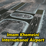
Imam Khomeini International Airport (IATA: IKA, ICAO: OIIE) is the main international airport of Iran, located 30 kilometers (19 mi) southwest of the city of Tehran, near the localities of Robat-Karim and Eslamshahr, on a 13,500-hectare (135 km2) site.
It was designed to replace Mehrabad International Airport, which is in the west of the city, now inside the city boundaries.
The airport was originally designated as Ahmadabad but was later renamed to "Imam Khomeini International Airport".
This package contains "Imam Khomeini International Airport" photoreal scenery based on VE satellites images with LOD19 quality.
| Filename: | Imam_Khomeini_Intl_Airport_2015_v10.zip |
| License: | Freeware, limited distribution |
| Added: | 28th June 2015, 23:54:13 |
| Downloads: | 6,963 |
| Author: | Khashayar Talebzadeh |
| Size: | 227.18 MB |
| Category: Flight Simulator X - AFCAD Files | |
| ZLXY - Xianyang Intl Airport - Xian, China |
|
Images related to this file:
File Description:
ZLXY - Xianyang Intl Airport - Xi'an, China
Xian Xianyang International Airport is the main airport serving Xi'an, capital of China's Shaanxi Province. Covering an area of 5 square kilometres (1.9 sq mi), it is the largest airport in China's northwest. The airport was the hub for China Northwest Airlines until the company was merged into China Eastern Airlines in 2002. Xi'an Airport is also the hub for Joy Air and a focus city for Hainan Airlines.
Using ADEx 1.55, aeronautical maps and Google Earth the default AFCAD has been updated to reflect today's situation.
| Filename: | ZLXY__Xianyang_Intl_Airport__Xian_China.zip |
| License: | Freeware |
| Added: | 21st April 2013, 11:48:36 |
| Downloads: | 1,114 |
| Author: | Menno C. Robert |
| Size: | 702.31 KB |
| Category: Flight Simulator X - AFCAD Files | |
| ZGHA - Changsha Huanghua International Airport - Changsha, China |
|
Images related to this file:
File Description:
Changsha Huanghua International Airport is the airport serving Changsha, Hunan province, People's Republic of China, as well as nearby cities such as Zhuzhou and Xiangtan. Located about 25 kilometres (16 mi) from downtown Changsha in the town of Huanghua in Changsha County, the airport has two terminal buildings and is currently among the busiest airports in China.
Terminal 1 is now under construction hence is not used by ai.
Using ADEx 1.67, Aeronautical maps and Google Earth the default airport has been reworked to reflect today's situation.
| Filename: | ZGHA__Changsha_Huanghua_International_Airport__Cha.zip |
| License: | Freeware |
| Added: | 8th March 2016, 18:43:58 |
| Downloads: | 741 |
| Author: | Menno C. Robert |
| Size: | 2.93 MB |
| Category: Flight Simulator X - Scenery | |
| USA East 10 metre mesh, Batch 4, Part 9 of 9 |
|
File Description:
USA EAST USGS 10 metre mesh terrain - FSX only, includes: IA, MN, WI, IL, IN, MI, OH, PA, NY, VT, NH, ME, MA, CT, RI. Part 9 of 9!
This constitutes 10 metre terrain mesh for a section of the USA, The whole USA East mesh files will abutt the US West Coast 10m mesh already available elsewhere, that was made by: Raimondo Taburet. Make sure you have your scenery terrain settings at about 5 metres in the FSX display dialogue for the mesh to show properly!
| Filename: | USA_East_10_metre_mesh_Batch_4_Part_9_of_9.zip |
| License: | Freeware |
| Added: | 11th May 2009, 10:18:22 |
| Downloads: | 1,020 |
| Author: | Wayne Evans |
| Size: | 28.84 MB |
| Category: Flight Simulator X - Scenery | |
| USA East 10 metre mesh, Batch 4, Part 5 of 9 |
|
File Description:
USA EAST USGS 10 metre mesh terrain - FSX only, includes: IA, MN, WI, IL, IN, MI, OH, PA, NY, VT, NH, ME, MA, CT, RI. Part 5 of 9!
This constitutes 10 metre terrain mesh for a section of the USA, The whole USA East mesh files will abutt the US West Coast 10m mesh already available elsewhere, that was made by: Raimondo Taburet. Make sure you have your scenery terrain settings at about 5 metres in the FSX display dialogue for the mesh to show properly!
| Filename: | USA_East_10_metre_mesh_Batch_4_Part_5_of_9.zip |
| License: | Freeware |
| Added: | 11th May 2009, 10:14:06 |
| Downloads: | 612 |
| Author: | Wayne Evans |
| Size: | 33.15 MB |
© 2001-2026 AVSIM Online
All Rights Reserved
Privacy Policy |