
Where Flight Simulation Enthusiasts Gather from Around the World!
AVSIM Library - Search Results

| Category: Flight Simulator X - Scenery | |
| MYGF - Freeport, Bahamas |

|
Images related to this file:
File Description:
MYGF includes separate international and domestic terminals as well as a terminal for general aviation. The old terminal shown in FSX has been removed and the control tower and fire station relocated as in real life. The scenery includes custom scenery objects; placement of library objects and landclass changes. Scenery is based on Google Earth imagery and photos taken locally, and it is optimized for use with UTX-TAC.
| Filename: | MYGF__Freeport_Bahamas.zip |
| License: | Freeware |
| Added: | 27th March 2013, 05:34:42 |
| Downloads: | 2,574 |
| Author: | Art Poole |
| Size: | 1.98 MB |
| Category: Flight Simulator X - Scenery | |
| LEGR Granada, Spain |
|
File Description:
Another default FSX airport brought to life for your enjoyment by "Project JBG".
This is an update of the default FSX airport LEGR of Granada, Spain. All taxiways and tarmac have been redone to true airport configuration including buildings, fire station, car parks, people, vehicles, extra aircrafts, various objects and vegetation. This compilation was made using ADE 9x version 1.47 with FSX (not tested with any other versions of FS)
| Filename: | LEGR_Granada_Spain.zip |
| License: | Freeware |
| Added: | 5th February 2011, 19:33:50 |
| Downloads: | 3,847 |
| Author: | Joe Garcia |
| Size: | 696.66 KB |
| Category: Flight Simulator X - AFCAD Files | |
| KWRI - McGuire AFB, Wrightstown, NJ v3.0 |
|
Images related to this file:
File Description:
This is a complete airport rebuild with new scale runways, ramps, taxiways, and service roads. Flight lines include Romeo Row (C-17A, C-5A), 305th / 514th AMW (C-17A, KC-10A), 108th ARW (ANG KC-135R), transient (cargo, fighter), and Marine (C-130, ground support, helicopter). This release also features a detailed fire station, POL facilities, updated signage, improved approach scenery, and parking (including hangar parking) for over 100 aircraft.
| Filename: | KWRI___McGuire_AFB_Wrightstown_NJ__v30.zip |
| License: | Freeware |
| Added: | 15th March 2013, 23:49:48 |
| Downloads: | 1,031 |
| Author: | Allen Laughmiller |
| Size: | 39.31 KB |
| Category: Flight Simulator X - AFCAD Files | |
| Hurlburt Field at Eglin AFB - Mary Esther, FL (KHRT) |
|
File Description:
Here is an improved version of the stock Hurlburt Field. I added many Military_Cargo and Military_Combat parking spaces. Added the fire station with fire trucks, added helipads, and static fork trucks, military trucks, tractor trailers and helicopters. The ramp on the east side of the field was too large and way too far away from the runway. I narrowed the ramp and moved it closer as much as
possible.
| Filename: | Hurlburt_Field_at_Eglin_AFB__Mary_Esther_FL_KHRT.zip |
| License: | Freeware |
| Added: | 9th May 2008, 01:09:53 |
| Downloads: | 1,218 |
| Author: | Jim Cook |
| Size: | 14.06 KB |
| Category: Flight Simulator X - AFCAD Files | |
| KDYS - Dyess AFB - Abilene, Texas, USA v2.0 |
|
Images related to this file:
File Description:
Located near Abilene, Texas, Dyess AFB is home to the US Air Force's 7th Bomb Wing (B-1B) and 317th Airlift Group (C-130). This is a complete airport rebuild with new scale runways, ramps, and taxiways. It includes accurate B-1B and C-130 ramps, detailed maintenance facilities, access roads, fire station, POL facilities, ICAO signage, enhanced approach scenery, and parking (including hangar parking) for over 150 aircraft.
| Filename: | KDYS__Dyess_AFB__Abilene_Texas_USA_v20.zip |
| License: | Freeware |
| Added: | 14th December 2013, 19:34:26 |
| Downloads: | 896 |
| Author: | Allen Laughmiller |
| Size: | 34.76 KB |
| Category: Flight Simulator X - Scenery | |
| KFMH - Otis ANGB - Falmouth, MA |
|
Images related to this file:
File Description:
Re-upload. Here is an improved version of the stock Otis ANGB, formerly Otis AFB. I added Military_Cargo and Military_Combat parking spaces. I added the fire station and fire trucks. I removed and replaced many default buildings, added additional buildings, replaced and moved the control tower. Added static fuel trucks, helicopters, construction vehicles, parking lots with cars and light poles.
Added, removed, or adjusted taxiways and aprons as needed
| Filename: | KFMH__Otis_ANGB__Falmouth_MA.zip |
| License: | Freeware |
| Added: | 13th May 2010, 03:26:30 |
| Downloads: | 1,738 |
| Author: | Jim Cook |
| Size: | 20.93 KB |
| Category: X-Plane - Scenery | |
| BR MA SNCW - Alcantara Launch Center v1.0.0 |
|
Images related to this file:
File Description:
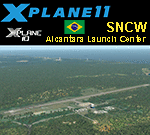
This is an X-Plane 11 and X-Plane 10 scenery package for Alcântara Launch Center Airport, Airbase, and Space Center (ICAO: SNCW, no IATA code), which is a military airport in the city of Alcantara, Maranhao, in Brazil. It includes corrected aprons, ramps, gates, taxiways, lighting system, village buildings, the satellite launching base, ortho-photoscenery for the airfield area, and (XP11 only) airport ground services (like push back). The SNCW airfield is located 16nm (30km) NW of São LuÃs Intl Airport (SBSL/SLZ). The Alcântara Launch Center (Portuguese: Centro de Lançamento de Alcântara - CLA) is a satellite launching base of the Brazilian Space Agency. This scenery was tested and is operational (as of January 11, 2018) in "X-Plane 11.11 64 bit", Windows 10 Home. It was also tested and is also operational (as of January 11, 2018) in "X-Plane 10.51 64 bit", Windows 10 Home. Only the default X-Plane 11 libraries, by Laminar Research, are needed. No third party libraries are used. A few extra objects are used and included in the package, thanks to autor and artist ThePrivateer. They are included in the package, no need to download them.
| Filename: | BR_MA_SNCW__Alcantara_Launch_Center_v100.zip |
| License: | Freeware |
| Added: | 12th January 2018, 00:09:54 |
| Downloads: | 68 |
| Author: | Rui Mesquita |
| Size: | 60.72 MB |
| Category: Prepar3D V1-4 - Scenery | |
| GMTT - Tangier Ibn Battuta Airport |
|
File Description:
Tangier Ibn Battuta Airpor (French: Aéroport de Tanger-Ibn Battouta), IATA: TNG, ICAO: GMTT, is an international airport serving Tangier (Tanger in French), the capital city of the Tanger-Tetouan-Al Hoceima region in Morocco. A new airport terminal building was opened in 2008 to provide for many more flights and increased passenger capability, as Tangier has grown rapidly and modernised.
Aircraft parking space of 40,640 square metres (437,445 sq ft) supports up to four Boeing 737s and one Boeing 747.
For small craft two dedicated sections are assigned. The air terminal is 12,000 m2 (129,167 sq ft) and designed to handle 1,250,000 passengers per year. The cargo terminal is 529 m2 (5,694 sq ft) of covered space.
The 3500 meter long runway 10/28 is open and is capable of handling all sizes of aircraft up to the size of a Boeing 747 and Airbus A380-800.
The airport has an ILS status (Loc – Glide – DME) and offers the following radionavigational aids: VOR – DME – NDB. PAPI lighting available for runway 10/28 for approaches from either direction.
| Filename: | GMTT__Tangier_Ibn_Battuta_Airport.zip |
| License: | Freeware |
| Added: | 9th June 2021, 00:08:54 |
| Downloads: | 776 |
| Author: | Eduardo Puelker |
| Size: | 10.22 MB |
| Category: Flight Simulator 2004 - Original Aircraft | |
| Van's RV-8 |
|
File Description:
In 1995, Van’s decided to re-visit the tandem concept. Even though the side-by-side RV-6\/6A had become the most popular homebuilt design ever, there was still a significant percentage of pilots who really wanted centerline seating. The consensus seemed to be that a new tandem airplane, optimized for cross-country flying, would be popular.\n\nThe "concept airplane" was dubbed the RV-8. A one-of-a-kind demonstrator was built in 1995 and introduced at Oshkosh. The cockpit was several inches wider than the RV-4, so space both front and rear was greatly improved. Really big people (high on the "bubba scale") who could not fit in earlier RVs now had an airplane they could fly. A front baggage compartment almost doubled the available baggage capacity and along with the usual compartment behind the rear seat, actually gave slightly more space than the RV-6\/6A. This package features a FSDSv2 model, custom panel, VC, moving parts, and two paint schemes. This aircraft is fun to fly, and also works well as an AI addition for GA routes.
| Filename: | Vans_RV8.zip |
| License: | Freeware, limited distribution |
| Added: | 2nd October 2004, 03:57:52 |
| Downloads: | 2,648 |
| Author: | Fred Choate |
| Size: | 460.79 KB |
| Category: Flight Simulator 2004 - AFCAD Files | |
| LGKO - Kos Airport, Greece |
|
File Description:
This file makes FS2004 use the correct taxiways and gates at the default scenery of LGKO, Kos Airport. It enlarges the east apron to the actual size found at an photo at airliners.net. It was created with AFCAD 2.11.
It contains enough parkings for many small and medium and prop airliners, some military fighter parkings at the west apron and five GA parkings at the northern end of east apron. There is enough space for one airliner up to the size of an MD11.
| Filename: | LGKO__Kos_Airport_Greece.zip |
| License: | Freeware |
| Added: | 2nd December 2003, 01:05:39 |
| Downloads: | 1,569 |
| Author: | Felix Hippmann |
| Size: | 3.51 KB |
© 2001-2026 AVSIM Online
All Rights Reserved
Privacy Policy |