
Where Flight Simulation Enthusiasts Gather from Around the World!
AVSIM Library - Search Results

| Category: Flight Simulator X - Aircraft Repaints, Textures and Modifications | |
| PA 28 Archer II PH-PAD Rotterdamsche Aero Club |

|
Images related to this file:
File Description:
Depicted : PH-PAD of the Rotterdamsche Aero Club ( RAC ) . Repaint is for Carenado's Piper Archer II and can be used in FS 9 & FS X . Full instructions and thumbnails included .
| Filename: | PA_28_Archer_II_PHPAD_Rotterdamsche_Aero_Club.zip |
| License: | Freeware |
| Added: | 12th December 2009, 15:53:27 |
| Downloads: | 189 |
| Author: | John Glanville / Carenado |
| Size: | 6.01 MB |
| Category: Flight Simulator X - Aircraft Repaints, Textures and Modifications | |
| PA 28 Archer II PH-RVG Rotterdamsche Aero Club |
|
Images related to this file:
File Description:
Depicted : PH-RVG of the Rotterdamsche Aero Club ( RAC ) . Repaint is for Carenado's Piper Archer II and can be used in FS 9 & FS X . Full instructions and thumbnails included .
| Filename: | PA_28_Archer_II_PHRVG_Rotterdamsche_Aero_Club.zip |
| License: | Freeware |
| Added: | 12th December 2009, 15:54:39 |
| Downloads: | 140 |
| Author: | John Glanville / Carenado |
| Size: | 6.68 MB |
| Category: Flight Simulator 2004 - AI Flight Plans | |
| University of North Dakota Cessna 172 & Piper PA-28 |
|
File Description:
Some flightplans for the University of North Dakota Cessna 172s & Piper PA-28s by Mark Heimer. For the repaints see the readme.
| Filename: | University_of_North_Dakota_Cessna_172__Piper_PA28.zip |
| License: | Freeware |
| Added: | 31st August 2011, 22:12:48 |
| Downloads: | 224 |
| Author: | Bas Hogeling |
| Size: | 2.73 KB |
| Category: Flight Simulator X - AFCAD Files | |
| V2 Christchurch Intl - NZCH - New Zealand |
|
File Description:
ADE Home Edition (Freeware) was used to design these BGL files: This is an update of my previous version, my previous version not required, these 2 files are only for the FSX default airport: one with the Xwind rwy 11/29 activated where both rwy's will now be used for takeoff/landing and one as default: all taxiways now updated to the Nov 07 AIP NZ ground movement charts, all taxisigns changed to match the taxiways with missing taxisigns added, assigned parking with extra parking, and for the Canterbury Aero Club the grass rwy 2L/20R is now open and start locations added, support vehicle roads rebuilt, extra fuel trucks and several other improvements, airport views are from the roof of control tower (when in tower view) fully tested with Ultimate Traffic/WOAI but not required, please view the readme before installation
| Filename: | V2_Christchurch_Intl__NZCH__New_Zealand.zip |
| License: | Freeware |
| Added: | 13th December 2007, 08:34:27 |
| Downloads: | 2,407 |
| Author: | Ray Smith |
| Size: | 17.1 KB |
| Category: Flight Simulator 2004 - Utilities | |
| ILS and GPS Approach Creator v1.1 for FS9 and FSX (for non-US/UK users) |
|
File Description:
The original version of this program did not work on computers in countries which use a comma as the decimal separator (apologies for that). Version 1.1 fixes this problem and should work in all countries (including the US and UK) regardless of the format of their decimal numbers. This is the full package, so you do not need to download version 1.0 as well. If the original version is working on your computer, then there is no need for you to download this version instead, as the two versions are functionally identical. This easy-to-use program allows the user to add an ILS and/or a GPS approach to any airport in FS9 or FSX. The user will be able to select the approach in the GPS unit, and request the approach from ATC. The ATC will then vector you to make an ILS or GPS approach. The AI will also be able to use the ILS approach, and you will hear them say so over the radio. The program was designed with the non-expert user in mind, and no familiarity with XML coding is assumed. The program supports up to four FS installations. The program needs to be run in conjunction with AFCAD (or a similar utility for FSX). You will also need the .NET Framework 2.0 and MSXML 4.0 installed on your computer. Tested with XP Home and Pro. Full instructions included.
| Filename: | ILS_and_GPS_Approach_Creator_v11_for_FS9_and_FSX_f.zip |
| License: | Freeware, limited distribution |
| Added: | 23rd December 2007, 15:18:15 |
| Downloads: | 4,046 |
| Author: | Martin Gleeson |
| Size: | 361.81 KB |
| Category: Flight Simulator 2004 - AFCAD Files | |
| Simflyers Washington Dulles (KIAD) with Active Crosswind Runway |
|
File Description:
A high spec AFCAD2 for the 'Simflyers' Washigton Dulles (KIAD) scenery. This is the first and only AFCAD2 available at Avsim for this scenery and has been built from scratch. Using the Crosswind runway technique, Runway 12/30 is now open for use at the same time as the 01R/19L and 01L/19R runways. A tower view is now available at the airport. All taxiways and gates/ramps are named and match the scenery. All gates and cargo ramps feature airline assignments. All concourses are represented to be as near real as possible. Concourse 'G' (United Express) does not exist on this scenery (it was not built when simflyers released the scenery), so ive placed 23 gates for United Express on the holding area, just to the south of the real life location of this concourse (see the screenshots). An extensive GA Apron is also provided. All traffic flows smoothly and this afcad will certainly bring the airport to life.
| Filename: | Simflyers_Washington_Dulles_KIAD_with_Active_Cross.zip |
| License: | Freeware, limited distribution |
| Added: | 10th July 2005, 20:47:27 |
| Downloads: | 2,459 |
| Author: | Lee Brompton |
| Size: | 1.26 MB |
| Category: Flight Simulator 2004 - Gauges | |
| FS2004 GPS Map View Gauge v3.0 |
|
File Description:
The ultimate gauge. The Map will show: Airports details (Runways ID's, length & ILS), VOR's and NDB's frequencies,
Intersections and waypoints, Airspaces, Approaches and flight routes. You can toggle the view
you require for your flight. Also you can zoom in/out to see the nearest airports, vor's and
ndb's. The map will indicate A/C heading flightplan title and waypoints ID's.
Version 3 includes more enhancements such as the ability to input the ICAO code or name of any airport and the map will
show all the frequencies of that airport including ATIS, ILS, AND COM. In addition, the map will show the active
runway designations, length and width.
You can also input ICAO code of any VOR/NDB and the map will show their frequencies.
There was a bug in v2.0, in which if you enter ( click on ENT )the ICAO code of an airport, you will lose the flight
plan loaded. Now you can go back to the flight plan and with the NEXT/PREV buttons you have the choice of where to start
your FP.
The gauge will show Flight Plan Title, originating and destination airports, active waypoint, waypoint index and FP
crusing altitude.
I addition, the gauge will show various useful information, such as, Runway IDs, lenght, width and approach magnetic heading,
Airport name, city, and type. NAV1/2 names, codes, distances and ETA's, ADF1/2 names and codes.
Finally, the gaugee will show other information, such as, magvar, indicated airspeed, mach, ground velocity, ambient
wind velocity and direction, bank angle , and a/c altitude ( radio height ).
All the information above and much more on a single gauge window.
| Filename: | FS2004_GPS_Map_View_Gauge_v30.zip |
| License: | Freeware, limited distribution |
| Added: | 14th September 2005, 14:19:46 |
| Downloads: | 10,842 |
| Author: | Talal Alhaj |
| Size: | 710.05 KB |
| Category: Flight Simulator X - Scenery | |
| LYBE Belgrade Nikola Tesla Airport |
|
File Description:
Belgrade Nikola Tesla Airport (IATA: BEG, ICAO: LYBE) is the primary international airport serving Belgrade, Serbia. Previously known as Belgrade International Airport, it was renamed in 2006 in honour of Serbian-American scientist and
inventor Nikola Tesla.
The airport is situated 12 km (7.5 mi) west, of central Belgrade, in the Surcin Municipality, surrounded by Syrmia's fertile lowlands. Passengers on the right hand side of planes descending from the east have a view of downtown
Belgrade, especially the districts of Cukarica and Novi Beograd. In 2008 the airport installed ILS CAT IIIb equipment to allow aircraft to land and depart in the heaviest of fog, which in past years led to numerous flight diversions
mostly in late December and early January.
The airport is owned and operated by the Public enterprise Aerodrom Nikola Tesla Beograd��. The company recorded profit of 21.5 million euros at the end of 2010.
The national flag carrier and largest airline of Serbia, Jat Airways, uses Belgrade Nikola Tesla as their main hub. It is also one of the hubs for low cost airline Wizz Air. Aviogenex charter airline, and air taxi airlines Air Pink,
Jat Airways AVIO taxi, Prince Aviation and Pelikan Airways also call the airport their home.
The airport charts are included.
This file has the right coordenates, with the apron and characteristics of the airport, airport vehicules and buildings, please take note the the gates numbers needed to changed: C1A= C11, C3A=C13, C5A=C15; general aviation parking
were added a extra number due to repetion on the numbers.
| Filename: | LYBE_Belgrade_Nikola_Tesla_Airport.zip |
| License: | Freeware |
| Added: | 8th November 2012, 03:32:04 |
| Downloads: | 8,833 |
| Author: | Anwar Gonzalez |
| Size: | 15.17 MB |
| Category: X-Plane - Scenery | |
| BR CE SNOB Sobral Airfield v1.0.0 |
|
Images related to this file:
File Description:
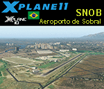
This is an X-Plane 11 and X-Plane 10 scenery package for VirgÃlio Távora Airport (ICAO: SNOB, IATA: QBX), which is the airport serving the city of Sobral, Ceara, Brazil. It includes corrected aprons, ramps, gates, taxiways, lighting system, city buildings, ortho-photoscenery for the airfield area, and (XP11 only) airport ground services (like push back). This scenery was tested and is operational (as of December 02, 2017) in "X-Plane 11.05 64 bit", Windows 10 Home. It was also tested and is also operational (as of December 02, 2017) in "X-Plane 10.51 64 bit", Windows 10 Home. Only the default X-Plane 11 libraries, by Laminar Research, are needed. No third party libraries are used.
| Filename: | BR_CE_SNOB_Sobral_Airfield_v100.zip |
| License: | Freeware |
| Added: | 3rd December 2017, 16:31:18 |
| Downloads: | 54 |
| Author: | Rui Mesquita |
| Size: | 9.18 MB |
| Category: X-Plane - Scenery | |
| BR PE SNRU - Caruaru Airport v1.0.0 |
|
Images related to this file:
File Description:
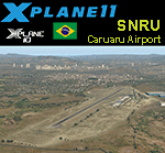
This is an X-Plane 11 and X-Plane 10 scenery package for Oscar Laranjeiras Airport (IATA: CAU, ICAO: SNRU), which is the airport serving Caruaru, Pernambuco, Brazil. It includes corrected aprons, ramps, gates, taxiways, lighting system, city buildings, ortho-photoscenery for the airfield area, and (XP11 only) airport ground services (like push back). This scenery was tested and is operational (as of December 12, 2017) in "X-Plane 11.1 64 bit", Windows 10 Home. It was also tested and is also operational (as of December 12, 2017) in "X-Plane 10.51 64 bit", Windows 10 Home. Only the default X-Plane 11 libraries, by Laminar Research, are needed. No third party libraries are used.
| Filename: | BR_PE_SNRU__Caruaru_Airport_v100.zip |
| License: | Freeware |
| Added: | 12th December 2017, 23:23:19 |
| Downloads: | 54 |
| Author: | Rui Mesquita |
| Size: | 8.63 MB |


© 2001-2026 AVSIM Online
All Rights Reserved
Privacy Policy |