
Where Flight Simulation Enthusiasts Gather from Around the World!
AVSIM Library - Search Results

| Category: Fly! II - Scenery | |
| KLIT to KDFW Flight Plan |

|
File Description:
This flight plan is from the Little Rock/Adams Field Airport (KLIT) to the Dallas/Fort Worth International Airport (KDFW). Included are waypoints, navaids and approach plates. The flight plan is 280 NM. Also included is a metar file. Web links are provided to download the airport diagrams.
| Filename: | KLIT_to_KDFW_Flight_Plan.zip |
| License: | Freeware |
| Added: | 13th October 2004, 04:33:55 |
| Downloads: | 63 |
| Author: | Wayne Roberts |
| Size: | 407.35 KB |
| Category: Fly! II - Miscellaneous Files | |
| KRKS to KFAR Flight Plan |
|
File Description:
This flight plan is from the Rock Springs-Sweetwater County Airport (KRKS) to the Hector International Airport (KFAR). Included are waypoints, navaids and ILS plate for Runway 35. The flight plan is 628 NM. Also included is a metar file. Web links are provided to download the airport diagrams.
| Filename: | KRKS_to_KFAR_Flight_Plan.zip |
| License: | Freeware |
| Added: | 28th October 2004, 00:06:48 |
| Downloads: | 170 |
| Author: | Wayne Roberts |
| Size: | 316.36 KB |
| Category: Fly! II - Miscellaneous Files | |
| KBOS to CYKZ Flight Plan |
|
File Description:
This flight plan is from the General Edward Lawrence Logan International Airport (KBOS) to the Toronto/Buttonville Municipal Airport in Canada (CYKZ). Included are waypoints and navaids. The flight plan is 387 NM. Also included is a metar file . Web links are provided to download the airport diagrams.
| Filename: | KBOS_to_CYKZ_Flight_Plan.zip |
| License: | Freeware |
| Added: | 19th January 2005, 16:05:24 |
| Downloads: | 48 |
| Author: | Wayne Roberts |
| Size: | 14.86 KB |
| Category: Fly! II - Miscellaneous Files | |
| KHWD to KSLC |
|
File Description:
This flight plan is from the Hayward Executive Airport (KHWD), California to the Salt Lake City International Airport (KSLC), Utah. Included are waypoints, navaids and arrival plate. The flight plan is 537 NM. Also included is a metar file. Web links are provided to download the airport diagrams.
| Filename: | KHWD_to_KSLC.zip |
| License: | Freeware |
| Added: | 19th May 2005, 03:51:23 |
| Downloads: | 53 |
| Author: | Wayne Roberts |
| Size: | 391.98 KB |
| Category: Flight Simulator 2002 - Scenery | |
| Elma Municipal Airport |
|
File Description:
FS2002 Scenery - Elma Municipal Airport
is 20 miles east of Bowerman
Field in Washington State. This rural GA airport is nestled
in the fertile Chehalis River Valley.
Optimized using the latest 2k2 design
techniques providing photoreal scenery for
the airport and surrounding area while
maintaining excellent fps performance.
| Filename: | Elma_Municipal_Airport.zip |
| License: | Freeware |
| Added: | 25th January 2003, 17:56:40 |
| Downloads: | 1,834 |
| Author: | Bob Bernstein |
| Size: | 3.11 MB |
| Category: Fly! II - Scenery | |
| Kenai Municipal Airport (PAEN) |
|
File Description:
TerraModels Scenery Development System by Allen Kriesman and Biber Salsa models were used to create the scenery for Kenai Municipal Airport (PAEN), Alaska. The taxiways were added using the program by Peter Jacobson. The FlyII designatior for this airport is ENA. No custom models were created for this airport.
| Filename: | Kenai_Municipal_Airport_PAEN.zip |
| License: | Freeware |
| Added: | 11th November 2003, 04:40:27 |
| Downloads: | 118 |
| Author: | Wayne Roberts |
| Size: | 236.09 KB |
| Category: Fly! II - Scenery | |
| Dillingham Airport & Sea Plane Base |
|
File Description:
TerraModels Scenery Development System by Allen Kriesman and Biber Salsa
models were used to create the scenery for Dillingham Airport (PADL), Alaska. The FlyII
designator for this airport is DLG. The taxiways were added using the program by Peter
Jacobson. No custom models were created for this airport.
| Filename: | Dillingham_Airport__Sea_Plane_Base.zip |
| License: | Freeware |
| Added: | 1st November 2003, 16:46:56 |
| Downloads: | 113 |
| Author: | Wayne Roberts |
| Size: | 93.69 KB |
| Category: Fly! II - Scenery | |
| Wakefield Municipal Airport (KAKQ) |
|
File Description:
TerraModels Scenery Development System by Allen Kriesman and Biber Salsa models were used to create the scenery for Wakefield Municipal Airport (KAKQ), Virginia. The new designation for this airport is KFYJ. The taxiways were added using the program by Peter Jacobson. No custom models were created for this airport.
| Filename: | Wakefield_Municipal_Airport_KAKQ.zip |
| License: | Freeware |
| Added: | 11th August 2003, 16:19:33 |
| Downloads: | 91 |
| Author: | Wayne Roberts |
| Size: | 187.1 KB |
| Category: Flight Simulator 2004 - Sounds | |
| Voicepack Update for Najaf International Airport |
|
Images related to this file:
File Description:

A voicepack update for the new Najaf International Airport in Iraq. Install using the 'Editvoicepack' software. After installation, instead of hearing the airport as "Oscar Romeo November India" over ATC you will hear it as "Najaf". Requires the Najaf airport scenery and AFCAD by Rick Marcinko (annajaf_orni.zip) on flightsim.com.
| Filename: | Voicepack_Update_for_Najaf_International_Airport.zip |
| License: | Freeware |
| Added: | 9th January 2010, 14:23:17 |
| Downloads: | 298 |
| Author: | Zafer El-Khatib |
| Size: | 77.7 KB |
| Category: Miscellaneous Files - General Utilities | |
| AgimSearch (Airport General Information Search) |
|
Images related to this file:
File Description:
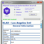
Airport General Information Search provides information such as,
General Info: Nearest City, Country, Elevation, Airport Type, Operation Type, Time Zone, Latitude, Longitude.
Airport Info: Heading, Length, Width, Altitude, Surface, ILS Frequency.
Communication Info: ATIS, APP, DEP, GND, TWR.
NavAid Info and Current Weather
AGIMSearch used data courtesy of smithplanet
| Filename: | AgimSearch_Airport_General_Information_Search.zip |
| License: | Freeware |
| Added: | 17th August 2017, 07:12:41 |
| Downloads: | 442 |
| Author: | Christopher Hall |
| Size: | 353.36 KB |


© 2001-2026 AVSIM Online
All Rights Reserved
Privacy Policy |