
Where Flight Simulation Enthusiasts Gather from Around the World!
AVSIM Library - Search Results

| Category: Flight Simulator 2004 - Scenery | |
| "Himalayan Peaks" LOD10 Mesh, Volume 6 - Jammu and Kashmir |

|
Images related to this file:
File Description:
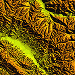
Highly detailed terrain mesh of the Jammu and Kashmir areas, N31-36 E76-78. The files in this package are based on Shuttle Radar (SRTM) Version 2 data but with many of the void areas, especially the most significant sections, filled with elevation data generated from topographic maps by Jonathan de Ferranti. While Jonathan's work is unrelated to flight simulation he kindly gave me permission to compile his data for use in FS. The result is a wonderful improvement in detail and accuracy over any existing mesh file, freeware or commercial, based on SRTM or DTED data alone.
Due to the large area of the Himalayas I've compiled the source data as two separate series: the "Himalayan Peaks" series covers prominent mountains and ranges in higher detail and locally overrides any existing LOD9 terrain mesh. In addition, a LOD9 "base mesh" series covering the entire Himalayas will be available for those who do not yet have an add-on terrain mesh of these beautiful mountains.
| Filename: | Himalayan_Peaks_LOD10_Mesh_Volume_6__Jammu_and_Kas.zip |
| License: | Freeware, limited distribution |
| Added: | 29th May 2010, 08:55:43 |
| Downloads: | 9,663 |
| Author: | Holger Sandmann, Jonathan de Ferranti |
| Size: | 52.19 MB |
| Category: Flight Simulator 2004 - Scenery | |
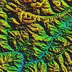
| "Himalayan Peaks" LOD10 Mesh, Volume 7 - K2 and Karakoram |
|
Images related to this file:
File Description:

Highly detailed terrain mesh of the Karakoram area, N35-37 E73-77. The files in this package are based on Shuttle Radar (SRTM) Version 2 data but with many of the void areas, especially the most significant sections, filled with elevation data generated from topographic maps by Jonathan de Ferranti. While Jonathan's work is unrelated to flight simulation he kindly gave me permission to compile his data for use in FS. The result is a wonderful improvement in detail and accuracy over any existing mesh file, freeware or commercial, based on SRTM or DTED data alone.
Due to the large area of the Himalayas I've compiled the source data as two separate series: the "Himalayan Peaks" series covers prominent mountains and ranges in higher detail and locally overrides any existing LOD9 terrain mesh. In addition, a LOD9 "base mesh" series covering the entire Himalayas will be available for those who do not yet have an add-on terrain mesh of these beautiful mountains.
| Filename: | Himalayan_Peaks_LOD10_Mesh_Volume_7__K2_and_Karako.zip |
| License: | Freeware, limited distribution |
| Added: | 30th May 2010, 09:56:27 |
| Downloads: | 9,474 |
| Author: | Holger Sandmann, Jonathan de Ferranti |
| Size: | 38.58 MB |
| Category: Flight Simulator 2004 - Scenery | |
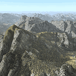
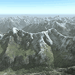
| "Himalayan Peaks" LOD10 Mesh, Volume 8 - Tirich Mir and Pamir |
|
Images related to this file:
File Description:
Highly detailed terrain mesh of the Tirich Mir and Pamir areas, N36-39 E71-74. The files in this package are based on Shuttle Radar (SRTM) Version 2 data but with many of the void areas, especially the most significant sections, filled with elevation data generated from topographic maps by Jonathan de Ferranti. While Jonathan's work is unrelated to flight simulation he kindly gave me permission to compile his data for use in FS. The result is a wonderful improvement in detail and accuracy over any existing mesh file, freeware or commercial, based on SRTM or DTED data alone.
Due to the large area of the Himalayas I've compiled the source data as two separate series: the "Himalayan Peaks" series covers prominent mountains and ranges in higher detail and locally overrides any existing LOD9 terrain mesh. In addition, a LOD9 "base mesh" series covering the entire Himalayas will be available for those who do not yet have an add-on terrain mesh of these beautiful mountains.
| Filename: | Himalayan_Peaks_LOD10_Mesh_Volume_8__Tirich_Mir_an.zip |
| License: | Freeware, limited distribution |
| Added: | 29th May 2010, 08:52:47 |
| Downloads: | 9,104 |
| Author: | Holger Sandmann, Jonathan de Ferranti |
| Size: | 47.94 MB |
| Category: Flight Simulator 2004 - Scenery | |
| Alps LOD10 Topo Mesh - Austria and Italy |
|
Images related to this file:
File Description:
Yet another terrain mesh package of the European Alps? Well, this one is different in that it is NOT primarily based on the Shuttle Radar (SRTM) data with their incomplete coverage of prominent peaks and ridges. Instead, most of the source data for this project were developed over many months by Jonathan de Ferranti using detailed topographic maps. While Jonathan's work is unrelated to flight simulation he kindly gave me permission to compile his data for use in FS. The result is a wonderful improvement in detail and accuracy over any existing SRTM- or DTED-based mesh file, freeware or commercial (a link to an extensive set of screenshot comparisons is included in the read-me file).
I've compiled the source data at LOD10 (38-m) grid resolution because the coverage area is smaller than most existing mesh files. Thus, anyone can use these files without having to first uninstall their current mesh set. Also included are LOD9 and LO8 buffer mesh files. Note: if you own Austria Professional 2004 with its 1:50,000 scale terrain mesh then you don't need this package!
| Filename: | Alps_LOD10_Topo_Mesh__Austria_and_Italy.zip |
| License: | Freeware, limited distribution |
| Added: | 30th May 2010, 09:46:58 |
| Downloads: | 62,954 |
| Author: | Holger Sandmann, Jonathan de Ferranti |
| Size: | 73.32 MB |
| Category: Flight Simulator 2004 - Scenery | |
| Alps LOD10 Topo Mesh - Switzerland and France |
|
Images related to this file:
File Description:
Yet another terrain mesh package of the European Alps? Well, this one is different in that it is NOT primarily based on the Shuttle Radar (SRTM) data with their incomplete coverage of prominent peaks and ridges. Instead, most of the source data for this project were developed over many months by Jonathan de Ferranti using detailed topographic maps. While Jonathan's work is unrelated to flight simulation he kindly gave me permission to compile his data for use in FS. The result is a wonderful improvement in detail and accuracy over any existing SRTM- or DTED-based mesh file, freeware or commercial (a link to an extensive set of screenshot comparisons is included in the read-me file).
I've compiled the source data at LOD10 (38-m) grid resolution because the coverage area is smaller than most existing mesh files. Thus, anyone can use these files without having to first uninstall their current mesh set. Also included are LOD9 and LO8 buffer mesh files. Note: if you own Switzerland Professional with its high-resolution terrain mesh then you don't need this package, at least not the Switzerland files!
| Filename: | Alps_LOD10_Topo_Mesh__Switzerland_and_France.zip |
| License: | Freeware, limited distribution |
| Added: | 30th May 2010, 09:51:03 |
| Downloads: | 58,993 |
| Author: | Holger Sandmann, Jonathan de Ferranti |
| Size: | 50.03 MB |
| Category: Flight Simulator X - Scenery | |
| Iceland Mesh and Land Class scenery, version 1.0 |
|
File Description:
Iceland Mesh uses sources from Jonathan de Ferranti who generously gave his
permission to create this mesh scenery from his data. The data has been then corrected for Flight simulator and resampled as LOD9 scenery. Included is also a Land classification for Iceland.
| Filename: | Iceland_Mesh_and_Land_Class_scenery_version_10.zip |
| License: | Freeware, limited distribution |
| Added: | 18th October 2007, 10:11:13 |
| Downloads: | 5,472 |
| Author: | Tatu Kantomaa, Janne Sinkkonen, Jonathan de Ferranti |
| Size: | 11.45 MB |
| Category: Flight Simulator 2004 - Scenery | |
| Faroes Islands Mesh and Scenery - Update for Version 2 |
|
File Description:
This small package provides still more ports and towns of the Faroes Islands. You need our mesh and scenery of the islands (faroesver2.zip), based on the free DEM data compiled by Jonathan de Ferranti. The package also includes updated information on the textures.
| Filename: | Faroes_Islands_Mesh_and_Scenery__Update_for_Versio.zip |
| License: | Freeware |
| Added: | 28th May 2006, 20:40:31 |
| Downloads: | 1,309 |
| Author: | Ryan Andersen and Peter H. Poulsen |
| Size: | 177.9 KB |
| Category: Flight Simulator 2004 - Scenery | |
| AI Boats |
|
File Description:
Three boats to add to scenery as AI (animated) boats using the information in ai_ships.zip by Holger Sandmann
| Filename: | AI_Boats.zip |
| License: | Freeware |
| Added: | 2nd July 2004, 20:19:47 |
| Downloads: | 4,140 |
| Author: | Larry Silsbee |
| Size: | 84.19 KB |
| Category: Flight Simulator X - Scenery | |
| Iceland 76m Terrain Mesh |
|
File Description:
This 76m terrain mesh covers the whole of Iceland and is derived from recently released source data produced by, and used with the permission of, Jonathan de Ferranti. It has been tested in FSX only but should work fine in FS2004. Improvements are most noticeable in the rolling interior of the country where the default FSX terrain resolution is relatively low.
| Filename: | Iceland_76m_Terrain_Mesh.zip |
| License: | Freeware |
| Added: | 16th October 2007, 14:45:53 |
| Downloads: | 2,364 |
| Author: | Michael Johnson / Jonathan de Ferranti |
| Size: | 13.06 MB |
| Category: Flight Simulator 2004 - Aircraft Repaints, Textures and Modifications | |
| Northair Bush Services, Aerosoft Beaver , Amphibian version |
|
File Description:
Here is the amazing Aerosoft Beaver Amphibian in the 'Northair Bush Services' livery. Pictures taken in the grandiose Misty Fjords scenery made by Holger Sandmann. Details in the download.
| Filename: | Northair_Bush_Services_Aerosoft_Beaver___Amphibian.zip |
| License: | Freeware |
| Added: | 8th December 2004, 22:33:32 |
| Downloads: | 796 |
| Author: | Leon Louis |
| Size: | 1.76 MB |
© 2001-2026 AVSIM Online
All Rights Reserved
Privacy Policy |